Disaster preparedness: Anybody listening?

We have been told: The Philippines is the most disaster-prone country in the world. So what has the government done to meet the challenge of protecting the people from typhoons, floods, tsunamis, earthquakes, fire and other calamities that occur every year, apart from designating school buildings to serve as “evacuation centers” for those displaced by typhoons, floods, fire, etc.?

In the 1970s, we filed a bill seeking the allocation of funds to build disaster shelters in coastal towns. More than 40 years later, Filipinos displaced from their homes still evacuate to rickety school buildings or are sheltered in second-hand tents to await relief goods—and disease, due precisely to the absence of necessary provisions that otherwise would be present in a shelter built for the purpose.

The head of the Philippine Institute of Volcanology and Seismology, Renato Solidum, has not been remiss in warning us about the “Big One,” a powerful temblor that may come at any time. He admonishes us to be prepared, not to sow fear and panic, but to be warned in order to be forearmed. He knows what he is talking about, and shouldn’t we be glad to have him around?

And at the risk of being called an alarmist, we repeat here (for the nth time) our suggestion to the government to set up an Earthquake Rescue Division to start in the metro area in coordination with local government units, which have ready personnel on call at any time. The rescue team should be composed of trained paramedics, members of the police and military, and volunteer doctors and nurses, with the government requiring representatives of medical companies that carry medicines and antiseptics (for corpses in body bags) that may be needed, and of construction firms that would donate heavy equipment for use in rescuing people trapped under collapsed buildings.

The government should also make

arrangements with various schools for the use of their grounds for tents and portable toilets to be set up for displaced families. An amply stocked food and water bank must be ready for such an emergency. Hundreds of tents will be needed, as well as body bags!

Like it or not (and Solidum also says so), high-rise buildings and residential houses can collapse in the course of the Big One. An estimated 34,000 people may die and hundreds of thousands may be injured. Such are the portents we face.

Before it happens, the preparedness of the government and the private sector is urgently needed—now. Is anybody listening? Hello, Undersecretary Ric Jalad, chief of the National Disaster Risk Reduction and Management Council!

Tangani Bencana Alam, Kemensos Gandeng RAPI

JAKARTA – Kementerian Sosial (Kemensos) menjalin sinergi dengan Radio Antar Penduduk Indonesia (RAPI) dalam upaya penanganan bencana alam. 

Mensos Khofifah Indar Parawansa berharap sinergi ini dapat semakin memperkuat upaya kesiapsiagaan, mitigasi, tanggap darurat, bantuan dan rehabilitasi sosial bagi korban bencana. 

“Peran RAPI sangat dibutuhkan. Terutama saat terjadi bencana alam dimana jalur komunikasi dan listrik terputus,” ungkap Khofifah saat menerima kunjungan Pengurus Nasional (Pengnas) Radio Antar Penduduk Indonesia (RAPI) di Ruang Kerja Mensos, Rabu (1/3/2017).  

Menurut Khofifah, keberadaan radio amatir terbukti menjadi salah satu bagian krusial dalam penyebaran informasi yang valid pada penanggulangan suatu bencana. 

Penyebaran informasi terkait bencana yang cepat dan akurat mampu mempercepat kordinasi dan layanan serta meminimalisir jumlah korban akibat bencana alam. Terlebih, kata dia, jaringan sinyal operator telepon selular belum merata di seluruh Indonesia. 

Eksistensi RAPI dalam memberi bantuan komunikasi darurat ini, kata Khofifah, tentu saja menjadi modal kuat dalam upaya penanganan bencana. Tidak hanya meminimalisir jumlah korban, komunikasi yang tepat dan akurat juga bisa membantu jangkauan bantuan bagi pengungsi. 

“Jadi kedepan diharapkan tidak ada lagi cerita masyarakat atau pengungsi yang terlantar karena bantuan tidak merata karena RAPI bisa menginformasikan dengan cepat titik-titik sebaran pengungsi,” ucapnya dalam siaran pers Biro Hubungan Masyarakat, Kementerian Sosial RI. 

Khofifah menambahkan, RAPI telah menjadi Sahabat Taruna Siaga Bencana (Tagana). Setiap kali terjadi bencana, Tagana dan RAPI bahu-membahu dalam memberi pelayanan kepada para korban. Oleh karena itu, Kemensos akan memperkuat kerjasama tersebut dalam bentuk nota kesepahaman (MoU). 

“Saat hari jadi Tagana 24 Maret mendatang akan ada penandatanganan MoU antara Kemensos dan RAPI dalam hal penanganan bencana,” tuturnya. 

Khofifah berharap kedepan kerjasama antara Kemensos dan RAPI bisa lebih ditingkatkan. Tidak hanya dalam hal penanganan bencana alam, namun juga berbagai persoalan sosial kemasyarakatan di wilayahnya masing-masing. 

Khofifah berharap, RAPI ikut membantu menyisir penyandang masalah kesejahteraan sosial (PMKS), sehingga bisa segera tertangani. (*)

sumber: timesindonesia

Pemda Diminta Punya Dana Tak Terduga untuk Bencana Alam

Jakarta – Banjir dan longsor di kawasan dataran tinggi Dieng, Kabupaten Wonosobo pada Minggu 26 Februari 2017 kemarin, diminta jadi pembelajaran untuk pemerintah daerah.

Anggota DPR dari Fraksi PKB Abdul Kadir Karding mengatakan, tiap pemerintah kabupaten atau kota harus menyiapkan anggaran dana tak terduga untuk antisipasi bencana alam. Paling tidak sediakan dana sekitar Rp 4-5 miliar.

Karding pun memuji pemerintah Provinsi Jawa Tengah yang sudah mempunyai dana tak terduga.

“Saya dengar Provinsi Jateng juga sudah menyiapkan anggaran dana tak terduga hingga Rp 42 miliar,” ucap Karding dalam keterangannya, Selasa (28/2/2017).

Bukan hanya itu, dia pun meminta relawannya, segera mengumpulkan informasi lokasi rawan banjir dan longsor di Temanggung, Wonosobo, Purworejo, dan Magelang.

“Kita berdoa bencana alam tidak terjadi, namun kita juga perlu siaga bila ujian bencana datang, agar tak tergopoh-gopoh,” kata Karding.

Dia menuturkan, berdasar informasi yang didapatkan dari Badan Nasional Penanggulangan Bencana (BNPB), sejak November hingga Desember 2016 kemudian Januari, Februari dan Maret 2017, La Nina akan terus meningkat sehingga potensi longsor akan semakin tinggi.

Bencana longsor dan banjir, kerap terjadi di Magelang, Temanggung, Wonosobo dan Purworejo sejak Oktober 2016 lalu.

“Semakin tinggi curah hujannya, semakin tinggi potensi longsor dan bencana yang akan dihadapi. Untuk itu relawan AKK, masyarakat dan pemerintah harus berupaya bersama,” tutur Karding.

Menurut Sekjen DPP PKB itu, bencana alam, ibarat bom waktu. Bisa meledak kapan saja, namun juga bisa diantisipasi dengan cara memotong kabel pemicunya.

“Selain soal tanggap bencana, juga mengubah perilaku, kegiatan merusak alam yang dapat memicu longsor dan banjir harus dihindari. Termasuk soal penambangan yang tidak tepat,” pungkas Karding.

sumber: Liputan6.com

Magelang Dilanda Sejumlah Bencana, Dua Orang Tewas

Dua orang meninggal dunia akibat bencana longsor di kawasan Bego Pendem, Dusun Jamburejo, Desa Kemiren, Kecamatan Srumbung, Kabupaten Magelang, Rabu (1/3/2017) sore.

Keduanya merupakan pasangan suami istri, Kadiyono (45) dan Lasmini (52), warga Dusun Santren, Desa Gunungpring, Kecamatan Muntilan, Kabupaten Magelang.

Kepala Pelaksana Badan Penanggulangan Bencana Daerah (BPBD) Magelang, Edi Susanto menuturkan, mereka meninggal setelah tertimpa material longsor berupa pasir saat sedang menambang secara manual.

Lokasi longsor adalah kawasan pertambangan galian C berupa tebing-tebing di lereng Gunung Merapi. Kondisi hujan deras yang terjadi Rabu sore memicu pergerakan tanah hingga terjadi longsor.

“Sekitar pukul 15.30 WIB dua korban sedang menambang, akibat hujan tebing setinggi 5 meter longsor, material pasir dan batu menimpa mereka,” ujar Edi, dalam keterangan pers, Rabu petang.

Korban sempat dievakuasi oleh rekan-rekannya sesama penambang, As’ari (40) dan Mahfud Saefudin (27).

Medan yang berat mengakibatkan proses evakuasi korban sulit dilakukan. Mobil ambulans pun tidak mampu menjangkau lokasi sehingga keduanya terpaksa dibawa menggunakan truk, setelah itu diangkut ambulans ke RSUD Muntilan.

Namun, nyawa mereka tidak dapat ditolong. Hasil pemeriksaan tim dokter RSUD Muntilan menyebutkan, korban mengalami luka parah di beberapa bagian tubuhnya, antara lain patah tulang pada rahang, tulang rusuk, kaki, perut, hingga kepala.

Kepala Polsek Srumbung AKP Suwidodo menyatakan, saat ini korban sudah diserahkan ke pihak keluarga untuk dimakamkan. Menurut dia, kecelakaan akibat bencana alam sudah sering terjadi di lokasi penambangan Gunung Merapi.

“Lokasi penambangan sangat rawan bencana, kami imbau untuk waspada,” kata dia.

Selain itu, Data BPBD Kabupaten Magelang menyebutkan tanah longsor terjadi di Dusun Karangsari dan Dusun Serut, Desa Bigaran; dan Dusun Sambeng 1 Desa Sambeng, Kecamatan Borobudur.

Material menutup sebagian akses jalan alternatif Borobudur-Kulonprogo Daerah Istimewa Yogyakarta.

Longsor juga terjadi di kawasan wisata religi Gunungpring, Kecamatan Muntilan. Material yang berasal dari tebing setinggi 6 meter menerjang kios-kios milik warga.

Adapun di Dusun Jagalan, Desa Trasan, Kecamatan Bandongan, terjadi angin puting beliung. Sedikitnya tujuh rumah rusak akibat musibah ini, sebagian besar rusak pada bagian atapnya.

Di Kecamatan Secang, tepatnya di perbatasan Desa Donomulyo dan Desa Sidomulyo tebing senderan makam setinggi 5 meter dan panjang 10 meter longsor hingga menutup sebagian jalan desa.

Di lokasi, tepatnya di jalan raya depan pabrik tekstil Patal Kecamatan Secang, beberapa pohon tumbang melintang di jalan raya. Kejadian ini menyebabkan akses lalu lintas utama Magelang-Semarang macet total.

“Arus lalu lintas sudah berangsung normal malam ini, pohon tumbang sudah terkondisi,” ujar Kepala Sub Bagian Humas Polres Magelang AKP Santoso.

Hujan intensitas tinggi juga menyebabkan debit aliran sungai Putih yang berhulu di Gunung Marapi meningkat.

Akibatnya sebuah mobil pengangkut pasir milik penambang hanyut di sungai, tepatnya di Desa Seloboro, Kecamatan Salam.

“Debit air masih besar, evakuasi truk akan dilakukan besok, Kamis (2/3/2017) pagi,” ujar Santoso.

sumber: KOMPAS.com

Have we underestimated the West’s super-floods?

In the late 1980s, a Japanese scientist named Koji Minoura stumbled on a medieval poem that described a tsunami so large it had swept away a castle and killed a thousand people. Intrigued, Minoura and his team began looking for paleontological evidence of the tsunami beneath rice paddies, and discovered not one but three massive, earthquake-triggered waves that had wracked the Sendai coast over the past three thousand years.


In a 2001 paper, Minoura concluded that the possibility of another tsunami was significant. But Tokyo Electric Power was slow to respond to the science, leaving the Fukushima Daiichi nuclear power plant unprepared for the 15-meter wave that inundated it in 2011. The result was a $188 billion natural disaster. More than 20,000 people died.

For the past several decades, paleo-hydrologist Victor Baker of the University of Arizona has been using techniques similar to Minoura’s to study the flood history of the Colorado Plateau. Like Minoura, he’s found that floods much larger than any in recorded history are routine occurrences. And like Minoura, he feels his research is being largely ignored by agencies and public utilities with infrastructure in the path of such floods.

Earlier this month, when a spillway at the nation’s tallest dam in Oroville, California, nearly buckled under the pressure of record rainfall, the consequences of under-estimating flood risks were brought into sharp relief. Dams aren’t built to withstand every curveball nature can throw — only the weather events that engineers deem most likely to occur within the dam’s lifespan. When many Western dams were built in the mid-20th century, the best science to determine such probabilities came from historical records and stream gauges.


But that record only stretches back to the late 1800s, a timespan Baker calls “completely inadequate.” Today, technology allows scientists to reconstruct thousands of years of natural history, giving us a much clearer picture of how often super-floods occur. “The probability of rare things is best evaluated if your record is very long,” Baker explains.

By combing the Colorado River, the Green River and others in the Southwest for sediment deposits and other flood evidence and then carbon-dating the results, Baker has concluded the short-term record severely underestimates the size and frequency of large floods. On the Upper Colorado near Moab, Utah, Baker and his team estimated the average 500-year flood at roughly 246,000 cubic feet per second, more than double the 112,000 cfs that scientists had estimated drawing on the stream gage record alone. Baker’s calculations put the 100-year flood at 171,000 cfs, also much greater than the previous estimate of 96,000 cfs. In comparison, legendary flooding in 1983 and 1984 that nearly overwhelmed Arizona’s Glen Canyon Dam, just downstream, peaked at just 125,000 cfs. (The dam has been bolstered since then, and today engineers say it can handle flows up to 220,000 cfs.)

In California, too, super-floods may be more common than previously thought. United States Geological Survey hydrologist Michael Dettinger and UC Berkeley paleoclimatologist B. Lynn Ingram have studied the paleo-flood record across a broad swath of California and discovered that such floods happen at least every 200 years, and maybe more frequently. The last one was in 1862. Thousands of people died, towns were submerged and the state’s economy was devastated, yet it was nowhere near the worst: One flood in the 1600s was at least twice as big.

In 2013, Dettinger and Ingram wrote in Scientific American that California was due for another huge water year. Their prediction has proven prescient. So much rain and snow has pounded California this winter that as of Feb. 21, half the state was under flood, rain or snow warnings. Creeks are overflowing their banks and flooding homes, and water managers were forced to spill excess water over the Oroville Dam’s emergency spillway for the first time in the dam’s 49-year history. On the night of Feb. 12, the sediment-choked water began eroding a hole in the spillway, threatening to release a wall of water. More than 180,000 residents fled to higher ground.

Luckily, emergency crews were able to patch the spillway, and people trickled back home. But Oroville isn’t alone — across the country, some 2,000 dams whose failure could cause loss of life are in need of repair, according to the Association of State Dam Safety Officials. And in many ways, Californians dodged a bullet: this winter’s precipitation was nowhere near as heavy as the storms Dettinger and Ingram have studied, and yet if Oroville’s reservoir hadn’t been depleted by years of drought, floodwaters could have easily overwhelmed the dam.

Does this mean dams like Oroville and Glen Canyon need to be fortified to withstand bigger storms? Officials from the Bureau of Reclamation are confident that Glen Canyon, at least, is equipped to handle even “extremely large hydrologic events.” And The U.S. Army Corps of Engineers is reluctant to apply paleo-hydrology research to existing infrastructure, in part because we’ve altered rivers so much that some Corps’ scientists believe ancient flood records are no longer realistic indicators of current risks.

But Baker believes it would be foolhardy to not at least create contingency plans for the possible failure of some of the West’s biggest dams. That Japanese officials were warned about Fukushima and didn’t act is “an embarrassment,” Baker adds. “We may have some similar things occurring in the United States, if we don’t seriously pay attention to this science.”

Krista Langlois is a correspondent with High Country News

Gempa 5,6 SR Terjadi di Dekat Pembangkit Nuklir Fukushima

Gempa 5,6 SR Terjadi di Dekat Pembangkit Nuklir Fukushima

Tokyo – Gempa berkekuatan 5,6 Skala Richter (SR) mengguncang wilayah timur laut Jepang, dekat Pembangkit Listrik Tenaga Nuklir (PLTN) Fukushima hari ini. Tak ada ancaman tsunami akibat gempa ini.

Badan Survei Geologi Amerika Serikat (USGS) menyatakan seperti dilansir kantor berita AFP, Selasa (28/2/2017), gempa tersebut terjadi pada kedalaman 42,3 kilometer di Samudera Pasifik, sekitar 34 kilometer timur laut kota Namie.

Menurut Badan Meteorologi Jepang, tak ada ancaman tsunami akibat gempa ini. Sejauh ini belum ada laporan kerusakan maupun korban luka akibat gempa. Namun sejumlah layanan kereta lokal sempat dihentikan akibat gempa. Gempa ini juga menyebabkan sejumlah gedung pencakar langit di Tokyo bergoyang.

Pihak Tokyo Electric Power, selaku operator PLTN Fukushima menyatakan tak ada gangguan yang terdeteksi di pembangkit nuklir tersebut usai gempa.

Sebelumnya pada 11 Maret 2011 silam, gempa dan tsunami dahsyat telah menimbulkan krisis di tiga reaktor PLTN Fukushima. Lebih dari 18.500 orang tewas dalam peristiwa tersebut.

Ini Upaya Efektif Tangkal Banjir di Jakarta

JAKARTA – Banjir di Ibu Kota adalah masalah pokok yang solusinya sangat kompleks. Pemprov DKI Jakarta memilih normalisasi sungai dan pembangunan sheet pile di bantaran kali sebagai jalan keluar. Namun, meski hal itu sudah dilakukan banjir masih saja menghampiri Ibu Kota beberapa hari belakangan ini.

Pengamat tata kota dari Universitas Trisakti, Nirwono Yoga menjelaskan, jika ingin menyelesaikan masalah banjir di Jakarta, hendaknya juga melibatkan daerah-daerah penyangga. Terutama daerah yang dialiri 13 sungai yang bermuara di Jakarta. Revitalisasi waduk dan situ di Jakarta, Depok, Bogor, Tangerang dan Bekasi (Jabodetabek) dinilai memiliki peran penting mengurangi banjir.

“Seandainya seluruh waduk dan situ, dari hulu sampai dengan hilir, dari puncak Bogor sampai ke ujung Jakarta itu dioptimalkan, artinya dikeruk, diperluas, artinya air hujan yang mengalir dari hulu ke hilir ditampung oleh waduk dan situ tadi, sehingga air yang terbuang (ke sungai) menjadi lebih sedikit,” jelas Nirwono kepada Okezone, Jumat (24/2/2017). 

Menurut Nirwono, ada 178 waduk dan situs di Jabodetabek yang bisa dioptimalkan dan dimanfaatkan untuk mengurangi banjir Jakarta. Karenanya, Pemprov DKI perlu membangun kerja sama dengan sejumlah pemerintah daerah. 

Selanjutnya, tambah Nirwono, yang belum dilakukan adalah membuat rencana induk saluran air kota. Nirwono percaya bahwa banjir salah satunya disebabkan karena saluran drainase tersumbat. 

“Jadi harusnya membuat rencana induk tadi, sehingga tahu bagaimana kemudian hubungannya, mulai dari saluran primer, sekunder, tersier sehingga kalau ada saluran yang mampet itu kita dengan peta tadi akan tahu persis di mana tersumbatnya kenapa dan sebagainya,” ujarnya.

“Ini PR yang pertama, jadi rehabilitasi seluruh saluran air dengan didukung rencana induk saluran air kota,” sambungnya.

Banjir Bandang di Bandung Barat, Dua Jembatan Rusak

Bandung – Banjir bandang yang melanda Kecamatan Gununghalu, Kabupaten Bandung Barat, Jawa Barat, pada Kamis (22/2/2017) sore tak hanya merendam ratusan rumah warga. Dua jembatan penghubung kampung pun rusak. Akibatnya, aksesbilitas warga pun terhambat.

Sekretaris Badan Penanggulangan Bencana Daerah (BPBD) Kabupaten Bandung Barat Hari Mustika mengatakan, banjir itu disebabkan luapan air dari Sungai Cidadap pasca-hujan deras yang mengguyur daerah tersebut.

“Akibat luapan tersebut, jembatan penghubung Desa Gununghalu dan Desa mekarwangi di Kampung Tonjong RT 04/09 rusak berat. Jembatan masyarakat putus di Desa Sirnajaya,” kata Hari kepada Kompas.com melalui pesan singkat, Kamis malam.

Banjir itu pun memaksa 19 kepala keluarga yang terdiri dari 58 jiwa mengungsi. Tak hanya itu, luapan sungai pun merendam 42 hektar area pesawahan. Barang-barang milik warga pun turut terseret banjir. Kerugian materil ditaksir mencapai Rp. 120 juta.

“Unsur Muspika bersama BPBD dan relawan melaksanakan evakuasi korban ke titik evakuasi di mess dan aula pabrik teh Montaya. Namun dari 19 kepala keluarga hanya beberapa yang berada di pengungsian. Sebagian besar mengungsi ke tempat saudara terdekat,” ujarnya.

Selain itu, lanjut Hari, BPBD Kabupaten Bandung Barat juga telah memberikan bantuan logistik berupa makanan siap saji, terpal, dan selimut untuk para korban.

Ia meminta masyarakat sekitar agar terus meningkatkan kewaspadaan terhadap adanya potensi banjir susulan.

“Kita bersama-sama melaksanakan pemantauan lokasi bencana untuk antisipasi terjadinya bencana susulan,” kata Hari.

Banjir bandang terjadi di Kampung Pasanggrahan, Desa Sirnajaya, Kecamatan Gununghalu pada Kamis (22/2/2017) sekitar pukul 15.30 WIB. Banjir itu sempat menggenang kawasan pemukiman warga dengan ketinggian air mencapai 2 meter.

“Banjir akibat luapan Sungai Cidadap yang diakibatkan hujan lebat di daerah hulu sungai, yang menyebabkan tergenangnya bangunan/rumah warga setinggi 1- 2 meter,” ucap Hari. 

sumber: KOMPAS.com

Hit by worst floods in a century, San Jose got little warning of impending disaster

over the last two weeks, heavy rains pushed water levels at Santa Clara County’s largest reservoir into the danger zone, with officials warning it could overflow.

That happened over the weekend, sending massive amounts of water into the Coyote Creek, which runs through the heart of San Jose.

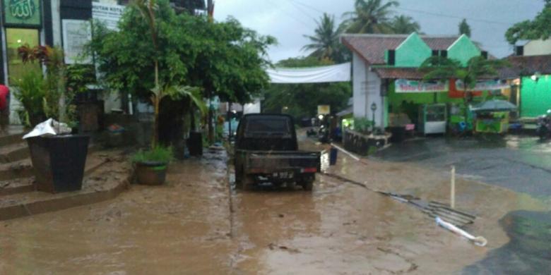
By Tuesday, the creek was overflowing at numerous locations, inundating neighborhoods, flooding hundreds of homes and forcing the frantic evacuations of more than 14,000 residents, who remained out of their homes Wednesday.

The worst flooding to hit Silicon Valley in a century left San Jose reeling and residents angry about why they were not given more warning that a disaster was imminent. Even city officials on Wednesday conceded they were caught off guard by the severity of the flooding and vowed a full investigation into what went wrong.

“If the first time a resident is aware that they need to get out of a home is when they see a firefighter in a boat, then clearly there has been a failure,” said San Jose Mayor Sam Liccardo. “There is no question that we’ll need to do things differently next time.”

Late Wednesday, Assistant City Manager Dave Sykes said officials had learned that the information they had on the capacity of Coyote Creek channel was not accurate. He also said the city was working with the Santa Clara Valley Water District to determine whether debris caused blockages that contributed to flooding.

“The creek spilled over the banks faster and higher than anybody expected,” said city spokesman David Vossbrink.

Residents told harrowing stories of water flowing into homes and flooding streets. Many had to be rescued by boat. Some said they were surprised they did not get urgent warnings about the extent of the flooding.

“They didn’t say it was going to go up as high as it did,” said Louis Silva, 48. He said that his possessions were swallowed up in the flood and that the city should have warned people about the scale of the disaster with a cellphone text alert or by knocking on doors.

“They should’ve put the footwork in to show the urgency of the situation,” Silva said. “It hurt everyone. … When Mother Nature shows up, she shows up.”

Dawn Rogers, 47, said she was in the mandatory evacuation zone but decided to hunker down instead of leave. She watched as firefighters took a boat down the street to rescue residents in homes that were flooded.

By 1 p.m. Tuesday, residents were rushing to fill up their cars with priceless valuables.

“It was scary,” Rogers said. “Being in a drought for all these years, you don’t ever think you’re ever in danger of a flood.”

Rob Souza, 49, thought he was prepared. He knew exactly where the floodwaters had previously risen on his William Street property, just west of Coyote Creek.

He spent eight hours Monday painstakingly building 3-foot walls of sandbags to protect his newly renovated cottage and his two-story home.

But by Tuesday morning, rising waters burst through the first sandbag wall, wrecking the cottage. Then Souza watched as the water rose to two feet above his home’s windowsill.

“It was like I was looking at an aquarium,” Souza said.

Then a window broke.

And then, Souza said, “it was all over.”

Anderson Reservoir, which is located in Morgan Hill about 22 miles south of downtown San Jose, had been releasing as much water as possible through its main outlet since Jan. 9, said Rachel Gibson, a spokeswoman for Santa Clara Valley Water District. The district was releasing water at a rate of 420 cubic feet per second through the reservoir’s outlet.

“We were trying to flood out as much water as we could in advance of any storms,” Gibson told reporters. “We have been pummeled by a number of storms since Jan. 9, so Anderson Reservoir was slowly filling up because more water was coming into it than we could practically let out of that outlet.”

Santa Clara water’s chief operating officer, Jim Fiedler, said his agency had been working in recent days with San Jose city officials on possible flood control options in case of a major event. He said the district had been in regular contact with city officials.

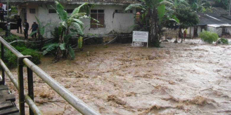
The situation came to a head over the weekend, when another round of heavy rain sent Anderson Reservoir over its tipping point, causing water to spill out of the lake and into Coyote Creek.

The first major flooding occurred Tuesday in the Rock Springs area of San Jose. San Jose firefighters paddled on rafts and waded through the chest-deep deluge, rescuing hundreds of residents trapped in homes and in trees.

Evacuation centers were set up at two community centers, where more than 300 residents stayed overnight. Two high schools were converted into overnight shelters, with dry clothes, food and cots.

Meanwhile, a damaged levee allowed water to flow onto U.S. 101 on Tuesday, forcing its temporary closure.

Coyote Creek slithers its way northwest from the reservoir to San Jose’s doorstep, where it proceeded to flood neighborhood after neighborhood, carving a destructive path through the heart of the city.

The creek crested to a height of 13.6 feet at a South San Jose river gauge point on Tuesday evening — nearly four feet above flood stage. The height shattered a previous record that had stood since 1922.

“This is a once-in-a-100-year flood event,” National Weather Service meteorologist Roger Gass said, referring to Coyote Creek’s surging height in South San Jose.

By Wednesday, the creek was no longer rising, but it was too late for some evacuees. 

City officials said some residents could be allowed home as early as Wednesday night, though Liccardo had warned earlier in the day that the water was highly contaminated with fuel, oil and possible sewage and posed a potential health risk. 

Officials said that on Thursday they would focus on assessing the damage and getting residents back home.

The approximately 14,000 people under mandatory evacuations hailed mostly from central San Jose. Evacuation advisories were also issued to 36,000 residents in a zone that covered a business and industrial area along a roughly seven-mile stretch of Coyote Creek.

By Wednesday evening, city officials had lifted some mandatory evacuations for homes north of Interstate 280. They also revised the number of residents impacted by evacuation advisories down to 22,000.

“We haven’t really had anything quite like this before,” Vossbrink said.