HHS launches TRACIE system to improve disaster preparation

The U.S. Department of Health and Human Services announced the launch of the Technical Resources, Assistance Center and Information Exchange (TRACIE) system for first responders and other key emergency and disaster response personnel.

This system was developed with national experts to address the preparedness needs for public health emergencies and disaster situations. The system includes a library of pertinent subject matter and resources that highlight experiences and tools.

The system also offers a forum where users can share their experiences and acts as a platform for collaboration and discussion on pending and current health threats. The system’s assistance center allows officials in state, local and tribal governments to connect with experts on various topics within the area of emergency and disaster response.

“Experience has shown that every disaster, large or small, has the potential to impact heath,” Nicole Lurie, HHS assistant secretary for preparedness and response, said. “TRACIE can help health and emergency management officials across the country learn about, share and apply best practices and experiences before, during and after disasters to protect health and potentially save lives.”

This project was a collaboration of national, state and local government agencies to foster national health and response systems.

HHS Launches Resources System to Improve Disaster Preparedness

HHS building

Health and emergency preparedness professionals now have access to the nation’s first and most comprehensive system of resources designed specifically to help communities better prepare for and manage the health impacts of disasters.

Sponsored by the U.S. Department of Health and Human Services’ Office of the Assistant Secretary for Preparedness and Response (ASPR), the Technical Resources, Assistance Center, and Information Exchange (TRACIE) features resource materials, a help line, just-in-time suggestions and tools to share information gleaned from real-life experiences in preparing for, responding to and recovering from disasters.

Dr. Nicole Lurie, HHS assistant secretary for preparedness and response said in a statement: “Experience has shown that every disaster, large or small, has the potential to impact health,” said . “TRACIE can help health and emergency management officials across the country learn about, share, and apply best practices and experiences before, during and after disasters to protect health and potentially save lives.”

ASPR developed TRACIE with a network of experts nationwide to address needs identified by stakeholders charged with preparing for public health and health care system emergencies. To support them, TRACIE provides technical resources and a technical assistance center, a comprehensive national knowledge center, and multiple ways to share information between federal, state and local officials.

TRACIE’s technical resources include a living library of audience-tailored and subject matter expert-reviewed topic collections and materials highlighting real-life tools and experiences. TRACIE’s resources include user rating and comments, which can be used to help choose the best resource for a particular need.

Through TRACIE’s assistance center, state, tribal, local and territorial officials can reach subject matter experts for technical assistance and consultations on a range of topics. Technical assistance could vary widely, including pediatric preparedness resources, crisis standards of care, tools to assess the readiness of hospitals and health care coalition for emergencies, lessons learned about delivering dialysis care during disasters, and more. Officials also can find training related to preparedness, response and recovery. The assistance center is available through a toll-free number, email, and online.

TRACIE also includes an information exchange. Through this forum, health care emergency preparedness stakeholders can discuss, collaborate and share information about pending and actual health threats and promising practices. Users also can exchange templates, plans and other materials through this feature.

Users can get advice, including just-in-time advice, from hundreds of health care, disaster medicine, public health and public safety professionals, through ASPR TRACIE. TRACIE’s free registration allows users to rate the usefulness of the resources and to access the information exchange.

ASPR TRACIE resulted from the collaborative efforts of local, state and federal government agencies, regional health-care coalitions, academia, and partners from the private sector and nongovernmental organizations.

ASPR leads HHS in preparing the nation to respond to and recover from adverse health effects of emergencies, supporting communities’ ability to withstand adversity, strengthening health and response systems, and enhancing national health security. HHS enhances and protects the health and well-being of all Americans by providing for effective health and human services and fostering advances in medicine, public health, and social services.

Govt acts on haze health issues

PKMK – Environment and Forestry Minister Siti Nurbaya Bakar has urged the Riau administration to pay close attention to health problems caused by haze currently blanketing parts of the province.

Fire-extinguishing efforts in Riau this year, Siti said, had been much better than in previous years.

“It’s much more manageable. One thing that needs a special effort is the health impacts of the haze,” said the minister during a two-day visit to Riau, which ended on Sunday.

“I’ve received reports that local administrations have established health posts. Therefore, I’ve brought Health Ministry secretary-general [Untung Soeseno Sutarjo] on my visit to Riau, as it is his ministry that properly understands the technical procedures to tackle the crisis Riau residents are currently facing,” said Siti.

Speaking on the visit, Untung confirmed that the Health Ministry would establish two additional health posts to tackle the health impacts of haze in Pekanbaru. Untung said that 14 specialist doctors and paramedics specially deployed from Jakarta would provide healthcare services at the posts.

He added that the two health posts had been established near Arifin Achmad Regional General Hospital (RSUD) in Pekanbaru so that it would be easier for medical workers to refer patients with serious medical problems who needed further treatment. “We are ready to dispatch more health workers if needed,” said the official.

According to the Health Ministry, half a ton of medicines for illnesses caused by haze, such as acute respiratory infections, asthma and inflamed throats, has been sent to Riau and is scheduled to arrive in Pekanbaru on Sunday evening.

The additional medical supplies, Untung said, had been provided to ensure that no more expired medicine was distributed to patients.

“There was a case of expired medicine, which was reportedly caused by a shortage of medical supplies at health posts,” he said.

On Friday, an official at a health post near Sukaramai market in Pekanbaru gave Inflation, an anti-inflammation medicine, to a smoke-affected patient, who later revealed to the press that the medicine had expired in March 2015. (ebf)

See more at: http://www.thejakartapost.com

Logan adopts tri-county pre-disaster mitigation plan

The Logan Municipal Council voted to have the city participate in a five-year tri-county pre-disaster mitigation plan, presented by the Bear River Association of Governments, on Tuesday night.

The pre-disaster mitigation plan provides strategies for jurisdictions on what the city can do to mitigate effects of natural hazards. Upon adopting the plan, cities can apply for funding to bring area-specific projects into their communities.

Regional Planner Zac Covington, who worked with Assistant Fire Chief Will Lusk to complete the Logan city section of the plan, said the goal is to minimize the damage a natural disaster could do to a community.

“We’re expecting most likely on the Wasatch Front, closer to Brigham City, an earthquake in the future; geologists say it’s coming soon,” Covington told the Municipal Council. “If it does come we’ll feel it over here.”

Covington, who worked with 39 municipalities to update their plans, said the purpose of reviewing them every five years is to “analyze existing data, to inform communities where their greatest risks are for natural hazards.”

In an interview with The Herald Journal, he added, “It determines potential risks, potential losses for residents, structures, infrastructures, helps them gauge their need for natural hazard planning for various hazards.”

Hazards in Cache Valley include wildfires, severe weather or land floods, or geologic-induced hazards, he said.

A unanimous vote by the council allowed the city to adopt the pre-disaster mitigation plan, which will make them eligible to apply for federal funding to reduce risks.

“This is really a very detailed and informative document,” Councilman Karl Ward said. “It’s good for everybody to … become familiar with where some of the high-risk areas are and how we as citizens ourselves can mitigate those kinds of things we’re at risk at.”

The council last adopted a plan in 2009.

source: hjnews.com

Disaster management plan for Smart Cities recommended

http://www.railnews.co.in/wp-content/uploads/2013/05/NDMA.jpgNEW DELHI: Cities being developed in coastal states as ‘Smart Cities’ under the Prime Minister’s flagship programme must be disaster resilient, the National Disaster Management Authority (NDMA) has told the government after a 10-month-long study on the Cyclone HudHud which had created wide-scale destruction in Andhra Pradesh and Odisha.

In a report titled ‘Strategies and Lessons for preparing better and strengthening risk resilience in coastal regions of India’, DMA explains how the ‘eye’ of the 2014 HudHud cyclone lay exactly over the Vishakapatnam city and caused widespread damage to property and natural resources though lot of lives were saved given advance preparations made.

“The smart cities being built and many more cities/towns which are coming up or located in the vulnerable coastal areas, need to be designed and built based on multi hazard resilient features. The smart cities and other cities being developed in coastal areas through Central Assistance must have a component of disaster management plan integrated with district disaster management plan,” the NDMA has now recommended to the Urban Development Ministry. The NDMA has further proposed the concept of’ Early Warning to the Last Mile’ to save lives.

“On receipt of information from Indian Meteorological Department of the approaching cyclone, the State Emergency Operation Centre would immediately through a web based early warning dissemination system send warning from Chief Secretary/Chief Minister right up to the last mile i.e. people living in far flung coastal areas and to fishermen through their mobiles or other systems so installed. This will help the people to become vigilant 48-72 hours before the landfall of cyclone and either shift to safer places such as Multipurpose Cyclone Shelters or to move to areas within the state which are not likely to be affected by cyclone,” the report says. It has also proposed that a database be prepared of pregnant women in their 4th trimester be to shift them to emergency care in hospitals before the cyclone strikes.

source: indiatimes.com

Indonesia declares emergency as brush-fire smoke chokes region

Indonesia declared a state of emergency Monday in a province choked with thick smoke from brush fires, as the pall continued to spread to other parts of Southeast Asia and fears mounted that worsening air quality could affect the international Grand Prix race set for Sunday in neighboring Singapore.

The emergency announcement in Indonesia’s Riau province on Sumatra island came as aircraft were deployed to water-bomb the raging blazes, and to seed clouds with chemicals in attempt to induce rain.

Indonesia had said Friday it would send more than 1,000 troops to fight fires in southern Sumatra, with smoke sickening thousands of people and pushing air quality to unhealthy levels across the narrow straits in Singapore and Malaysia.

Indonesia has vowed in previous years to end the seasonal fires, but has failed each time to stop the so-called “haze” caused by slash-and-burn land clearing on the islands of Sumatra and Borneo, where large areas of forest and brush concessions are held by palm oil and pulp-and-paper companies. The problem has been occurring during the region’s annual dry season for the past two decades.

Indonesian troops will be sent to the provinces of South Sumatra and Jambi, two of the main hotspots, Indonesia’s National Disaster Mitigation Agency (BNPB) said.

If necessary, the agency will also send in additional helicopters to help water-bomb fires.

“We have mobilized national resources to put out the fires,” newly appointed BNPB chief Willem Rampangilei said in a news release.

South Sumatra, one of the main centers of the fires, has alone reported 22,585 cases of acute respiratory tract infections since Friday.

Singapore has passed legislation allowing authorities to fine companies that cause or contribute to haze, regardless of whether they have an office in the city-state. But Indonesia has previously faced criticism for failing to hand over information about the suspected culprits.

Early on Friday, Singapore’s Pollutants Standard Index rose to 248, which categorizes the air as “very unhealthy,” at one level below the index’s highest air pollution category of “hazardous.”

The organizers of the Singapore Grand Prix were also keeping a close watch on the situation. The F1 race, to be held this weekend, has taken place in Singapore since 2008 and draws hordes of tourists and racing enthusiasts from the region and beyond.

“In the event that the haze caused visibility, public health or operational issues, Singapore GP would work closely with the relevant agencies before making any collective decisions regarding the event,” the Singapore GP said in a statement.

However, a decision on whether it will be safe to race will be made by FIA Race Director Charlie Whiting after consulting with drivers and teams.

The race has always been held at this time of year, and while there has been some haze in past years, it has never prevented the race from going ahead.

Singapore, which was voting in a general election on Friday, advised citizens against strenuous outdoor exercise.

Wire services

sumber: aljazeera

Japan floods: City of Joso hit by ‘unprecedented’ rain

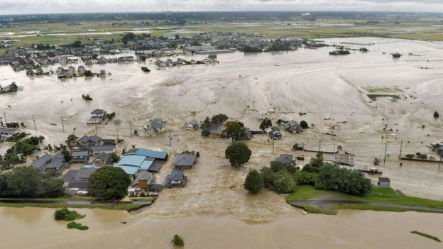
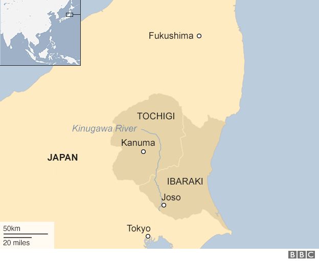
The city of Joso, north of the capital, Tokyo, was hit by a wall of water after the Kinugawa River burst its banks. Helicopter rescue teams have been plucking people from rooftops.

At least eight people are still missing and 100 need rescuing.

The rains come a day after a tropical storm brought winds of up to 125km/h (78mph) to central Aichi prefecture.

The chief forecaster at the Japan Meteorological Agency (JMA), Takuya Deshimaru, said that the rainfall was “unprecedented” for that part of Japan.

“We can say this is an abnormal situation and there is imminent serious danger,” he went on.

Floodwater in Joso, Japan

Analysis by the BBC’s Mariko Oi in Japan

Japan gets hit by, on average, 20 to 30 such storms each year. This is the 18th this year so despite the heavy rainfall that we have experienced over the last few days, it was difficult to predict how severe the damage would be.

The Kinugawa River bursting its banks took even experts by surprise, especially because of the widespread areas that it has affected.

Just as in previous natural disasters, including the 2011 earthquake and tsunami, Japan’s non-combat military Self-Defence Force is playing a major role in the rescue operations and it is receiving lots of praise so far.

But there are concerns that these storms are getting stronger in recent years and more preparations may be needed in the future.


The hardest-hit areas have been Ibaraki and Tochigi prefectures. Japan’s Meteorological Agency had put both regions on its highest level of alert.

Saori Mori, who lives close to the Tone River in the town of Abiko, told the BBC that “the water is right up to the top of the banks now”.

“We have been told to pack and prepare to evacuate as soon as we are told to,” Ms Mori said, adding that she and her family were “getting ready for a fast exit”.

Television footage from Joso in Ibaraki showed people clinging to the rooftops before helicopter rescue teams winched them to safety.

Entire homes and cars were carried away on the torrent as the Kinugawa River burst its banks after two days of heavy rainfall. The flood waters reached as far as 8km (5 miles) from the breach.

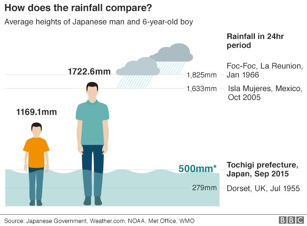
In Tochigi, more than 500mm (19 inches) of rain fell in 24 hours in places, double the amount that normally falls there throughout the whole of September, according to Japanese public broadcaster NHK.

Graphic

Parts of central Tochigi have seen almost 600mm of rain since Monday evening, breaking records.

Many other areas of eastern and north-eastern Japan have also been issued weather warnings, including Fukushima prefecture, home to the still-damaged nuclear plant hit in 2011’s earthquake and tsunami.

The downpour overwhelmed the site’s drainage pumps, a spokesman for operator Tokyo Electric Power (Tepco) said. Huge volumes of water, used to cool the plant’s crippled reactors, are being stored at the site.

Landslides and flooding

The Fire and Disaster Management Agency said 15 people had been injured across Japan. Two were elderly women seriously injured after being knocked over by strong winds.

The BBC’s Mariko Oi says seven people are missing in Joso and one in Tochigi prefecture, and the authorities fear that number will rise.

She said officials confirmed 265 people had been rescued, but at least 100 remain in need of help as rescue efforts are hindered by the night time.

Some areas have had power cuts and transport was disrupted, with many air and train services cancelled or delayed. Some roads were also closed.

Prime Minister Shinzo Abe said the authorities were doing their best.

“The government will stand united and do its best to deal with the disaster… by putting its highest priority on people’s lives,” he told reporters.

Last month, powerful Typhoon Goni hit Japan’s southernmost main island of Kyushu, killing at least one person and injuring 70 others.

Map: Kinugawa River area

Disasters require a community response

http://www.redcross.org/images/MEDIA_CustomProductCatalog/m8640101_514x260-strengthening-regional-disaster-response-asia.jpg

The anniversaries this week of Hurricane Katrina (10th) and Tropical Storm Irene (4th) carry lessons for a nation and for a community that cares about its most vulnerable members.

Here in the Berkshires, we learned on the fly how to pull together to support neighbors hit by disaster. When, in Williamstown, five percent of the non-student population all at once became homeless, the town government, faith communities, college, and individuals rallied to shelter them, to help salvage their possessions, and to support them in handling their shock. Most of the approximately 300 people lived in The Spruces, a retirement mobile home community.

The Red Cross and FEMA then helped move the recovery forward. Most of those displaced are now in permanent housing (though, sadly, for some that has meant leaving the area). And in the coming weeks, applications will be open for Highland Woods, the new senior affordable housing complex made possible by Higher Ground, with state, town, and college support.

This experience, and the relationships that it built, have opened our eyes to the challenges of responding to disasters.

There is another lesson worth noting, though. Somehow, as was the case in New Orleans and is true across America, our most vulnerable citizens live in the most dangerous places, by economic necessity.

The most effective, and most humane preparation we make, therefore, is the difficult but vital work of identifying and moving people in jeopardy before the next disaster strikes.

David Mangun Williamstown The writer is president of Higher Ground, the nonprofit group formed to support survivors of Tropical Storm Irene and to advance affordable housing in the region.

source: http://www.berkshireeagle.com/letters/ci_28707462/letter-disasters-require-community-response

4.0 earthquake strikes near Mammoth Lakes

Earthquake strikes near Mammoth Lakes

A shallow magnitude 4.0 earthquake was reported Saturday morning 10 miles from Mammoth Lakes, according to the U.S. Geological Survey. The temblor occurred at 6:34 a.m. Pacific time at a depth of 4.3 miles.

According to the USGS, the epicenter was 73 miles from Clovis, Calif., 73 miles from Sanger, Calif. and 77 miles from Reedley, Calif.

In the last 10 days, there have been no earthquakes of magnitude 3.0 or greater centered nearby.

This information comes from the USGS Earthquake Notification Service and this post was created by an algorithm written by the author.

Earthquake, tsunami threat examined to prepare for worst

WHEN the 2004 Boxing Day tsunami struck, killing 230,000 people across 14 countries, the level of death and devastation came as a wake-up call to governments and disaster managers.

The 9.1 magnitude undersea earthquake that triggered an upward lift of the seabed by several metres and displaced 30 cubic kilometres of water was the third largest in recorded history.

The resultant tsunami travelled at 800kmh through deep water before slowing and increasing in height by up to 10 metres as it crashed ashore.

The Indonesian island of Sumatra and its Aceh northern tip alone saw 168,000 people killed.

Surging waves hit against the breakwater in Udono in a port town of Kiho, Mie Prefecture, central Japan on September 21, 2011. Surging waves hit against the breakwater in Udono in a port town of Kiho, Mie Prefecture, central Japan on September 21, 2011. Daiji Yanagida

By comparison, the 5.8 magnitude earthquake experienced off the Sunshine Coast was barely a ripple causing only minor structural damage and no injuries.

In fact our region is more at risk from an onshore earthquake than a tsunami triggered by one off-shore.

That does not mean it’s a threat ignored.

A series of planning exercises rolled out over the past couple of years have tested early warning systems, evacuation plans and disaster coordination at a local, state and federal level.

Professor Tim Smith, the inaugural director of the University of the Sunshine Coast Sustainability Research Centre, warns that while the plans in place are robust, their efficacy won’t be fully understood until tested by a real event.

He says the key to minimising risk is to keep exploring ways to improve community resilience.

Geoscience Australia puts the chance of a M (magnitude) 5.5 directly under the urban strip running from the Sunshine Coast, through Brisbane to the Gold Coast is a 1-in-1200-year event.

“If the 1989 M5.4 Newcastle earthquake is anything to go by, a M5.5 under this urban strip could be damaging, particularly to lower-rise older buildings on soft soils,” a spokesman said.

“However low, the potential for a magnitude 5+ earthquake onshore, and its impact, is many times m

Geoscience Australia says tsunami risk in eastern Australia predominantly comes from large earthquakes south of New Zealand with the main impact likely to be to the southern states of Victoria and Tasmania.

“Queensland is fairly well protected from tsunami in general,” the spokesman said.

“Very large (M8.5+) earthquakes in the Solomon Islands and Vanuatu will cause large tsunami that are directed towards Queensland, but the Great Barrier Reef acts as a giant barrier so the wave energy getting to the Queensland coast is diminished significantly.

“A large (M6.5+) earthquake on the continental shelf might cause a moderate tsunami that might do some damage to very low-lying infrastructure, but as the chance of a M6.5 occurring off the Sunshine Coast is a 1-in-5000 year event, meaning the overall risk is very small.”

Despite this Geoscience Australia has modelled many “Rim of Fire” earthquake scenarios which may create a tsunami and then modelled whether a generated tsunami is likely to affect the Australian coastline.

The Queensland Government conducted a study in 2013 to identify the extent of tsunami hazard for the Queensland east coast.

A site specific study was conducted for the Sunshine Coast which identified the continuous dune system provided protection for most of the community.

Vulnerable areas were defined as those areas that are less than 10 metres above sea-level and within one kilometre from beaches as well as the water edges of harbours and coastal estuaries.

Responsibility for evacuation plans for vulnerable coastal communities rest with the relevant local authorities.

“Each local government has a Disaster Management Plan based on risk and hazards,” a Palaszczuk Government spokesman said.

“The Palaszczuk Government works continuously with local governments and Disaster Districts to improve planning and disaster response.

“Our government is working with all councils to enhance their Emergency Alert arrangements to ensure communities are warned of impending threats.”

In February, the State Disaster Coordination Centre participated in Exercise PACWave15, an international tsunami response exercise coordinated nationally through the Joint Australian Tsunami Warning Centre.

“This exercise was used to test the ability of the State Disaster Coordination Centre to receive and forward alert messaging from the Joint Australian Tsunami Warning Centre to disaster management response stakeholders,” a spokesman said.

“The principle of disaster management is ‘all hazards’ based, so the response to an earthquake is similar to other disaster events.

“Local government regularly exercise disaster response mechanisms through practical exercising as well as desktop analysis.”

ore likely than that of an offshore earthquake and tsunami impacting south-east Queensland.”

source: sunshinecoastdaily