Japan floods: Death toll rises to 176 as Abe visits affected areas

Soldiers carry an elderly woman away from flood water on July 8, 2018 in Kurashiki near Okayama, Japan.

Tokyo (CNN)Landslides and flooding caused by torrential rain in Japan have killed another 21 people in what has become one of the deadliest natural disasters to hit the country since the earthquake and tsunami at Fukushima in 2011.
A total of 176 people have been killed since the downpour began late last week, Japanese Chief Cabinet Secretary Yoshihide Suga said Wednesday. Another nine are missing.

Some 75,000 responders have been deployed to the area for search and rescue operations. Suga warned that thunderstorms and landslides in the coming hours could pose further danger.

Japanese Prime Minister Shinzo Abe was in Okayama Prefecture Wednesday morning, surveying the damage in one of the hardest-hit areas.
He viewed the damage from above in a helicopter and visited an evacuation center. He’s expected to visit the devastated city of Kurashiki and meet with the Okayama governor later Wednesday.

Abe canceled a trip to Belgium, France, Saudi Arabia and Egypt to focus on disaster relief efforts.

Hundreds of thousands of people were forced to flee their homes, and those unable to leave took shelter on rooftops during the heavy flash flooding that hit the country’s streets.

Japanese public broadcaster NHK reported about 364 millimeters (14.3 inches) of rain fell between 5 a.m. and 7 a.m. Sunday in the city of Uwajima — approximately 1.5 times the average monthly rainfall for July.

In Sukumo City in Kochi prefecture, 263 millimeters (10.3 inches) of rain fell in two hours, NHK said.
More than 20,000 people were killed or went missing during the Fukushima disaster, when a 9.0-magnitude earthquake hit Japan, triggering a tsunami and nuclear meltdown at the Fukushima nuclear plant.

source: CNN’s Jessie Yeung contributed to this report

Amid Japan’s Flood Devastation, Survivors Dig Out

KURASHIKI, Japan — As rain poured and the creeks and rivers that course through the city of Kurashiki began to rise, Miyuki Komada repeatedly tried to call her 70-year-old mother, who was home sick with a cold.

But Ms. Komada, 37, could not get through. And heavy rain Friday drowned out the sound of evacuation sirens. When she and her sister arrived after 9 p.m. they found their mother dozing.

As they drove her out, water was already nearing knee height. Soon after, a nearby levee broke, and water surged to shoulder height within a half-hour, Ms. Komada said.

“If I hadn’t come, my mother would have stayed in bed,” she said. “I’m glad I came.”

As she searched through mud and standing water for what few valuables could be salvaged from the family home on Monday, the risk her mother would have faced was clear. The water line climbed to the second floor of the two-story house, stopping halfway up the windows.

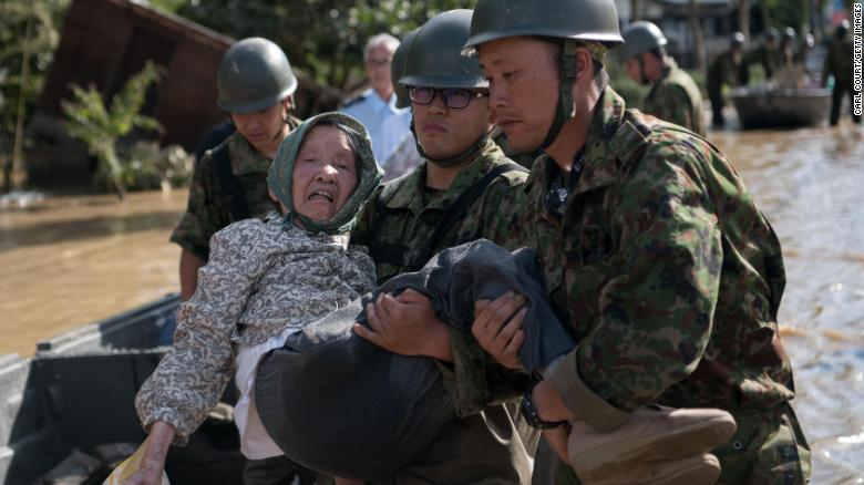
Japanese soldiers patrolled the neighborhood, knocking on doors and asking if everyone was safe from the rains, which produced jarring images of widespread destruction, a reminder that a country known for its orderliness is not immune to the chaos of natural disasters.

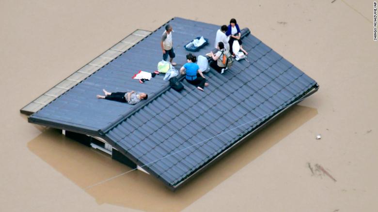
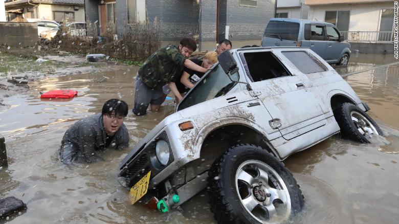
The sudden surge of floodwaters in this area of western Japan proved deadly for many. Of the 124 people killed as of early Tuesday morning, 28 were here in the Mabi district of Kurashiki, the public broadcaster NHK reported. To the west, Hiroshima Prefecture reported 45 dead. An additional 63 people were missing.

Thousands are displaced, too. In Okayama Prefecture, which includes Kurashiki, 4,234 people were staying in shelters as of Monday morning, according to the Sanyo Shimbun, a local daily newspaper.

Prime Minister Shinzo Abe canceled a trip to Europe and the Middle East set for later this week to respond to the disaster.

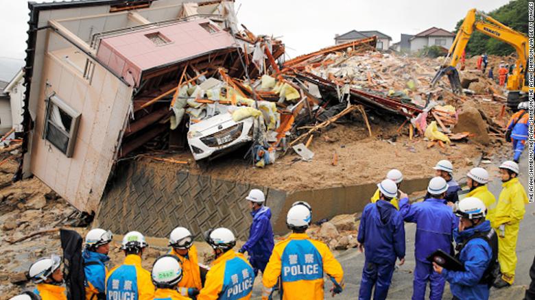
Military and rescue service helicopters slowly circled in the blue skies on Monday, surveying the damage and searching for missing people. Warm, sunny weather helped ease the immediate threat of more flooding. But water continued to carve across what was once a road in Mabi. Deep sand and a roof that had been deposited across both lanes made passage impossible on anything but foot.

This area is usually considered one of the safest in Japan, sheltered from typhoons and with little history of deadly earthquakes or tsunamis. After the 2011 earthquake and tsunami on Japan’s northeastern coast that killed nearly 16,000 people, some moved to this area seeking safety.
Image
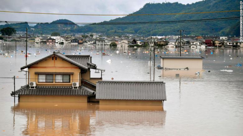
Houses in Kurashiki remained submerged on Monday.CreditKyodo News, via Associated Press

Now even this relatively placid area of one of the world’s most prosperous countries feels perilous to those who witnessed the destruction.

“It was quite frightening,” said Tamae Hirose, 57. She had driven through the rising water to safety.

“I just hit the gas, because I knew I couldn’t stay here,” she said.

After returning, she combed through her house, sweeping out water and mud while looking for anything to salvage.

“We don’t know what to do yet,” she said. “All I can do is stay in the evacuation center, come back and clean and look for a new place. I don’t think we can ever live here again.”

Mieko Tamura, 70, said she had experienced a flood once previously here, in 1976. But the water came only to knee height, and she was not worried.
Image
Flooding was still severe on Monday in the Mabi area of Kurashiki.CreditIssei Kato/Reuters

“This time it was so quick,” she said as she cleared debris from the yard of her beauty parlor, where chunks of grass were torn up and a tadpole swam in a puddle.

A loose timber had smashed her front window, and the interior was damp with water and mud. Nothing of value survived.

“Some people around here look like they want to steal stuff,” she said. “I don’t care. They can take anything.”

The flooding has punished Japan’s robust industrial sector as well. Mazda suspended production at factories in Yamaguchi and Hiroshima Prefectures, while Daihatsu halted operations at plants in four prefectures, NHK reported.
Comments

The Times needs your voice. We welcome your on-topic commentary, criticism and expertise.

The Asahi Aluminium Industrial Company plant in Okayama exploded late Friday after workers evacuated during the flooding. Neighbors said they had had no warning that the plant posed such a risk.
Image
A resident carrying water on Monday near submerged and destroyed houses in Mabi.CreditIssei Kato/Reuters

Volunteer firefighters had been meeting with local officials when the plant erupted.

“There was a sound like thunder or lightning,” said Junichi Kawata, a volunteer firefighter. “Then I turned around it was like a big fireball. The sky was so red.”

Shattered glass and a collapsed ceiling injured his wife, Hiromi, who had been at home. It took her six hours to receive treatment for the cut on her head because of the difficulty in navigating traffic in the floodwaters.

“We never expected the plant to explode,” she said as she wiped off her daughter’s set of traditional Hina dolls, which she placed in the sun to dry. The dolls were ruined, she said, but she planned to dispose of them in a ceremony rather than throw them away.

Officials from the plant were visiting neighbors Monday to apologize, said Takashi Nakano, a spokesman for Asahi Seiren Co., the parent company of the aluminum plant.

“This is the first time to have such an accident,” he said. “But since we have not conducted site inspection yet, I cannot comment on anything at the moment.”

Ms. Komada, who rescued her mother on Friday, returned Monday for memories of her father. He died four years ago, and a small tablet with his name that was placed near the family Buddhist altar was damaged along with the altar itself.

She placed the tablet and a few mud-smeared photos on a tarp to dry. “Today we came for my father’s tablet,” she said. “Tomorrow we will start the full cleanup.”

source: nytimes.com

Japan floods: At least 122 dead after heavy rain and landslides

(CNN) The rain may have stopped in Japan, but the country is facing a long recovery process after floods and landslides killed at least 122 people in the southwest, officials said Tuesday.

At least 27 people are missing, said the nation’s Fire and Disaster Management Agency.

With emergency rain warnings lifted, the country is turning its focus to search and rescue efforts. Police, fire departments and the military are scouring affected areas for those unaccounted for.

“We will unite and move swiftly to deliver those necessities to the disaster victims by coordinating closely with local government,” said Prime Minister Shinzo Abe in a meeting with the disaster response task force, also noting “the future need” to improve evacuation centers and temporary housing.

Residents began the cleanup, wading through flooded houses and streets.

Rescue operations continue at a collapsed house on July 8, 2018 in Kumano, Hiroshima, Japan.

Rescue operations continue at a collapsed house on July 8, 2018 in Kumano, Hiroshima, Japan.

Thousands of houses have been damaged, and even the ones that stand intact have been impacted. Nearly 17,000 households are still without power, and phone lines are down across multiple prefectures.

Further complicating repair efforts is the fact that many railroads and highways are closed, too flooded to operate, placing many affected areas out of reach.

Homes destroyed

Rains began late last week and intensified over the weekend. Rivers overflowed, landslides crushed buildings, and cars were swept away by floodwater.

“The record rainfalls in various parts of the country have caused rivers to burst their banks, and triggered large-scale floods and landslides in several areas,” Cabinet Secretary Yoshihide Suga said Sunday.

People wait to be rescued on the roof of a house in Kurashiki, Okayama prefecture.

People wait to be rescued on the roof of a house in Kurashiki, Okayama prefecture.

Two million people were forced to flee their homes, advised or ordered by the government to evacuate. Some, unable to leave, took shelter on their rooftops as flash floods swallowed entire streets.

In Kurashiki near Okayama, soldiers were deployed to carry elderly residents from their homes into waiting boats.

Soldiers carry an elderly woman away from flood water on July 8, 2018 in Kurashiki near Okayama, Japan.

Soldiers carry an elderly woman away from flood water on July 8, 2018 in Kurashiki near Okayama, Japan.

Kazuhiko Ono, who owns a secondhand book store in Hiroshima city, was unable to return to his home and store when the rains first arrived. His wife and children took shelter in the second floor of their home, while the store filled up with water.

“I’m so sad I lost many books,” Ono said. “I can never find them anymore.”

Hiroshima and Ehime prefectures were some of the hardest hit, though nine others were also heavily impacted.

Residents try to upright a vehicle stuck in a flood hit area in Kurashiki, Okayama prefecture on July 9, 2018.

Images from Kuyashiki, a city on the southern coast of Okayama Prefecture, show cars overturned or buried in mud.

Japanese public broadcaster NHK reported about 364 millimeters (14.3 inches) of rain fell between 5 a.m. and 7 a.m. Sunday in the city of Uwajima — approximately 1.5 times the average monthly rainfall for July. In Sukumo City in Kochi prefecture, 263 millimeters (10.3 inches) of rain fell in two hours, NHK said.

Residential buildings are partially submerged in floodwaters caused by heavy rains in Kurashiki, Okayama prefecture, southwestern Japan, Saturday, July 7, 2018.

Residential buildings are partially submerged in floodwaters caused by heavy rains in Kurashiki, Okayama prefecture, southwestern Japan, Saturday, July 7, 2018.

Suga warned that although the rain warnings had been lifted, residents should still watch for landslides. Those participating in cleanup efforts should be careful to avoid heat-related issues, because the next few days are expected to be hot and clear.

Prime Minister Abe announced on Monday that he has canceled a planned trip to Belgium, France, Saudi Arabia and Egypt to concentrate on the disaster relief effort.

About 73,000 personnel have been mobilized for search-and-rescue efforts.

source: cnn

Bali volcano erupts again, spewing lava and shooting ash

https://pbs.twimg.com/media/DhHCeAoUwAMzYV2.jpg

THE Mount Agung volcano on the Indonesian tourist island of Bali erupted on Monday evening, ejecting a 2000-metre-high column of thick ash and hurling lava down its slopes.

The Indonesian geological agency’s Agung monitoring post said a loud explosion from the mountain began just after 9pm and lasted more than 7 minutes.

“Flares of incandescent lava” reached 2 kilometres from the crater, it said.

It said the alert level for Agung has not been raised and the exclusion zone around the crater remains at 4 kilometres.

Last week, Bali’s international airport closed for half a day due to volcanic ash from Agung, disrupting travel for tens of thousands.

Monday’s eruption was “strombolian,” the geological agency said, which is the mildest type of explosive volcanic eruption. It warned people living near rivers to exercise caution, particularly in wet weather, because of the risk of fast- moving flows of muddy volcanic debris.

The volcano, about 70 kilometres northeast of Bali’s tourist hotspot of Kuta, last had a major eruption in 1963, killing about 1100 people.

It had a dramatic increase in activity last year, forcing the evacuation of tens of thousands of people, but had quietened by early this year. Authorities lowered its alert status from the highest level in February.

Indonesia, an archipelago of more than 250 million people, sits on the Pacific “Ring of Fire” and is prone to earthquakes and volcanic eruptions. Government seismologists monitor more than 120 active volcanoes.

Disaster preparedness can help save lives in your community

https://wtop.com/wp-content/uploads/2017/12/SMOKE-DETECTOR-727x485.jpg

From flooding to tornados to home fires, it’s impossible to know when disaster will strike.

What’s important is taking the necessary precautions to prevent accidents, and knowing how to respond in cases of emergency — otherwise known as being Red Cross Ready.

In Central Ohio, the most common disasters tend to be home fires, which usually are preventable and disproportionately affect the elderly and children. Home fires kill seven people every day in the U.S., and more than 60 percent of these deaths occur in homes without smoke alarms.

To address the more than 5 million homes without smoke alarms, the American Red Cross and fire departments are canvassing at-risk neighborhoods to install free smoke alarms, replace alarm batteries and provide fire prevention and safety education. Through the Home Fire Campaign and Sound the Alarm initiative, the goal is to reduce death and injury from home fires by 25 percent by 2020. So far, more than 1 million smoke alarms have been installed and more than 1 million people have been educated about home fires.

As a founding member of the Red Cross’ Annual Disaster Giving Program, Nationwide helps the organization with immediate resources to respond to disasters whenever and wherever they happen. For organizations calling the region home, supporting disaster relief efforts can serve as a team-building activity.

“Get your team involved by hosting a Red Cross training course such as First Aid and CPR,” suggests Mary Lynn Foster, CEO for the Ohio Buckeye Region of the American Red Cross. “Engage your employees in a meaningful services project through our Sound the Alarm campaign, installing free smoke alarms and educating our communities on fire safety. Encourage your employees to become Red Cross volunteers and make an impact right here in Central Ohio and beyond.”

Whether a parent or teacher, a teenager or senior citizen, there is applicable Red Cross training. Through the Sound the Alarm campaign alone, more than 431 lives have been saved, including 10 in Central Ohio.

Guatemala’s Fuego volcano disaster: updates

Dozens were killed and thousands evacuated after the most violent eruption of Guatemala’s Fuego volcano in more than four decades.

Volcan de Fuego, or Volcano of Fire, spewed an 8km-long stream of red-hot lava and shot out a thick plume of black smoke and ash on Sunday that rained down onto several regions and the capital, Guatemala City, 30km away from the hardest-hit area.

Now the search for survivors is under way, along with the grim task of recovering bodies. 

Here are the latest updates:

Tuesday, June 5

  • Guatemala’s disaster agency reported that superhot volcanic material is once again flowing down the south side of the volcano. The agency ordered new evacuations from areas around it.

  • Rescue workers pulled more bodies from under the ash and rubble, bringing the death toll to at least 70. But officials said just 17 had been identified so far because the intense heat of the volcanic debris flows left most bodies unrecognisable. 
  • As dawn broke, the volcano continued to rattle with what the country’s volcanology institute said were eight to 10 moderate eruptions per hour – significantly less intense than Sunday’s big blasts.

  • But the head of Guatemala’s National Institute of Seismology, Eddy Sanchez, said the worst of the volcanic activity appears to be over.

  • READ MORE

    Fuego volcano disaster: ‘My daughter must have been swept away’

    “It is evident that the volcano’s energy has decreased and its tendency is to continue decreasing. No eruption is imminent in the coming days,” the Republica newspaper quoted him as saying. 

  • The grim recovery effort continued on Tuesday. Using shovels and backhoes, emergency workers dug through the debris and mud, perilous labour on smouldering terrain still hot enough to melt the soles of shoes.

  • Bodies were so thickly coated with ash that they looked like statues. Rescuers used sledgehammers to break through the roofs of houses buried in debris up to their rooflines to check for anyone trapped inside.

  • In the village of San Miguel Los Lotes, evidence of destruction was everywhere. 

  • “Access is very difficult, and it’s really hot in the places where we’re trying to dig bodies out of the ash. The deeper you dig, the more intense the heat,” Enrique Morales, a rescue worker, told Al Jazeera.

  • “This is the epicentre of the slide, and it’s the focus of the rescue efforts right now,” said Al Jazeera’s David Mercer, reporting from the scene. 

  • “Rescue workers are pouring out across this area, going into houses and pulling out bodies. In just 15 minutes we’ve seen four bodies pulled out. There’s not a lot of hope for survivors.”
  • President Jimmy Morales declared three days of national mourning for the “irreparable losses”.


Monday, June 4

  • The number of fatalities from a massive volcano eruption rose to 62 on Monday. Only 13 of the dead have been identified so far, Mirna Zeledon, a spokeswoman for Guatemala’s National Institute of Forensic Sciences, said.

  • Among the dead were four people, including a disaster agency official, killed when lava set a house on fire in El Rodeo village in southern Guatemala, National Disaster Coordinator Sergio Cabanas said. Two children were burned to death as they watched the volcano’s second eruption this year from a bridge.

  • A deadly pyroclastic flow – which can travel down a mountain at speeds of more than 100km/hr – shot from the volcano and is likely the cause of most deaths, volcanologist David Rothery told Al Jazeera. 

  • A hot flow of mud, ash and gas swept down from Fuego after a new blast on Monday morning that interrupted disaster workers pulling bodies from the brown sludge that engulfed El Rodeo.

  • Survivor Hilda Lopez said the volcanic mud swept into her village of San Miguel Los Lotes, just below the mountain’s flanks, and she didn’t know where her mother and sister were.

  • “We were at a party, celebrating the birth of a baby when one of the neighbours shouted at us to come out and see the lava that was coming. We didn’t believe it, and when we went out the hot mud was already coming down the street. My mother was stuck there, she couldn’t get out,” said Lopez, weeping and holding her face in her hands.

  • Three shelters were housing about 650 people, Marcia Martinez from the disaster relief agency told Al Jazeera. 

  • “There is this volcano dust everywhere… There are a lot of people here trying to recover bodies or searching for the missing,” said Al Jazeera’s David Mercer, reporting from the scene. 

  • Rescuers were using heavy machinery and shovels to find victims. Disaster agency chief Sergio Cabanas said helicopters rescued 10 people from areas hit by thick ash, mud or lava.

  • The Guatemalan President Jimmy Morales declared a state of emergency in the states of Chimaltenango, Sacatepequez and Escuintla.

  • According to volcanologist Eddy Sanchez, the volcano’s temperatures reached 700 degrees Celsius.

  • Guatemala City’s international airport re-opened after it was closed by falling ash from the eruption of the volcano to the west.
  • Fuego is one of Central America’s most active volcanos. It was the second eruption this year and the biggest in decades.

Translation: National Civil Police continue the search and rescue of people who have been hurt by # VolcanDeFuego in the village El Rodeo in Escuintla. So far they have rescued children and adults. – Guatemalan National Police 

  • Guatemalan officials say more than 3,200 people have been evacuated after the volcanic eruption.

  • “We saw the lava was pouring through the corn fields and we ran towards a hill,” Consuelo Hernandez, a survivor, told Al Jazeera.

    • Translation: #VolcanDeFuego Resources and humanitarian assistance are being carried out in order to help people affected by the eruption of the Fuego volcano. – National Coordinator for Disaster Reduction in Guatemala

Sunday, June 3 

  • Authorities in Guatemala say 18 more people have been confirmed killed by a volcanic eruption, raising the death toll to 25.

  • Disaster agency spokesman David de Leon said late Sunday the bodies were found in the community of San Miguel Los Lotes. 

  • Rescuers have struggled to reach rural residents cut off by the eruption, which also wounded at least 20. Authorities have been unable to account for an undetermined number of people and say they fear the death toll could rise.

  • The Volcan de Fuego, or “volcano of fire,” exploded in a hail of ash and molten rock shortly before noon Sunday, blanketing nearby villages in heavy ash. 


The True Scope of the Disaster in Puerto Rico

The U.S. flag, next to a damaged Puerto Rican flag, flies in the municipality of Yabucoa.

Just about nobody believes Puerto Rico’s official death toll for Hurricane Maria. Researchers and journalists alike generally accept that the island’s tally of 64 people killed by the storm last September is a massive undercount, so obviously inaccurate that the Puerto Rican government has agreed to review and revise its figures. But with Puerto Rico still in disarray—from the storm’s casualties, population changes from migration, and the absence of basic services—information on the complete human cost of the catastrophe is still woefully incomplete.

What little is known, however, portends a grim conclusion: that Hurricane Maria is one of the most significant and destructive natural disasters in recent American history.

A new study in The New England Journal of Medicine, conducted in part by researchers at Harvard University, sheds new light on what’s really happened on the island. The team found that there were over 4,600 deaths potentially attributable to the hurricane, a 70-fold increase over official estimates. The survey also measured high rates of migration among people displaced by the storm and, after it passed, long periods where residents faced a loss of basic services.

As I spent time reporting from Puerto Rico three weeks after Maria, two things became clear: The storm had a staggering impact on the island, and it was almost impossible to translate that impact to observers on the mainland. People are used to gauging the scale of far-off events by relying on official estimates of death tolls, dollar amounts of damages, and the like. But in the immediate chaos following the storm, the “official” story was clearly inadequate. Some residents just went missing. Some got swept away in floods. Entire branches of extended families went silent. Mudslides and floods essentially turned remote places in the island’s mountainous interior into islands in their own right. In my attempts to assess the human burden of the hurricane, I asked everyone I interviewed—over two dozen people—if they knew someone who’d disappeared, died, or had fled to the mainland. Each person told me “yes.”

Official counts are obviously more difficult to perform than my anecdotal one, and not just because of scale: Further complicating the picture are mismatched systems in hospitals and morgues that might double-count some victims or misidentify others, as well as tough decision-making over just what counts as a hurricane-related death. In its survey of over 3,200 Puerto Rican households, the team behind the new study tried to get around those difficulties by asking families directly about the deaths of loved ones.

Using Machine learning tools to gain new insights from Earthquake data

Scientists at the Columbia University have discovered a totally new way to study earthquakes. They picked out different types of earthquakes from three years using machine learning algorithms. According to them, these machine learning methods pick out very subtle differences in the raw data that we’re just learning to interpret.

Scientists particularly identified earthquake recordings at The Geysers in California, one of the world’s oldest and largest geothermal fields. They assembled a catalog of 46,000 earthquake recordings, each represented as energy waves in a seismogram. They then mapped changes in the waves’ frequency through time, which they plotted as a spectrogram—a kind of musical roadmap of the waves’ changing pitches, were they to be converted to sound.

Seismologists ordinarily dissect seismograms to evaluate a quake’s size and where it started. However, taking a gander at a seismic tremor’s recurrence data rather enabled the scientists to apply machine-learning tools that can pick out patterns in music and human speech with minimal human information. With these instruments, the scientists diminished every seismic tremor to a spectral “fingerprint” reflecting its subtle contrasts from alternate quakes, and after that utilized a clustering algorithm to sort the fingerprints into groups.

Using this machine learning algorithms, they found repeating patterns of earthquakes appear to match the seasonal rise and fall of water-injection flows into the hot rocks below, suggesting a link to the mechanical processes that cause rocks to slip or crack, triggering an earthquake. It also helped them in making a link to the fluctuating amounts of water injected below ground at The Geysers during the energy-extraction process, giving the researchers a possible explanation for why the computer clustered the signals as it did.

Felix Waldhauser, a seismologist at Lamont-Doherty said, “The work now is to examine these clusters with traditional methods and see if we can understand the physics behind them. Usually, you have a hypothesis and test it. Here you’re building a hypothesis from a pattern the machine has found.”

Scientists noted, “These methods could also help reduce the likelihood of triggering larger earthquakes — at The Geysers, and anywhere else fluid is pumped underground, including at fracking-fluid disposal sites. Finally, the tools could help identify the warning signs of a big one on its way — one of the holy grails of seismology.”

The exploration became out of a bizarre aesthetic coordinated effort. As a musician, Holtzman had for quite some time been receptive to the odd hints of quakes. With sound designer Jason Candler, Holtzman had changed over the seismic floods of chronicles of outstanding quakes into sounds, and after that speeding them up to make them understandable to the human ear. Their joint effort, with examine coauthor Douglas Repetto, turned into the basis for Seismodome, a recurring show at the American Museum of Natural History’s Hayden Planetarium that puts people inside the earth to experience the living planet.

As the exhibit evolved, Holtzman began to wonder if the human ear might have an intuitive grasp of earthquake physics. In a series of experiments, he and study coauthor Arthur Paté, then a postdoctoral researcher at Lamont-Doherty, confirmed that humans could distinguish between temblors propagating through the seafloor or more rigid continental crust and originating from a thrust or strike-slip fault.

Encouraged, and looking to expand the research, Holtzman reached out to study co-author John Paisley, an electrical engineering professor at Columbia Engineering and member of Columbia’s Data Science Institute. Holtzman wanted to know if machine-learning tools might detect something new in a gigantic dataset of earthquakes. He decided to start with data from The Geysers because of a longstanding interest in geothermal energy.

Paisley said, “It was a typical clustering problem. But with 46,000 earthquakes it was not a straightforward task.”

Thus, Paisley found a mind-blowing solution of a topic modeling algorithm that picks usual frequencies in the dataset. When applying another algorithm, they identified the most common frequency combinations in each 10-second spectrogram to calculate its unique acoustic fingerprint. Finally, a clustering algorithm, without being told how to organize the data, grouped the 46,000 fingerprints by similarity.

At the point when the specialists coordinated the groups against normal month to month water-infusion volumes crosswise over Geysers, an example hopped out: A high infusion rate in winter, as urban areas send more run-off water to the territory, was related with more quakes and one kind of flag. A low mid-year infusion rate compared to fewer tremors, and a different flag, with transitional flags in spring and fall.

Now, scientists are planning to apply these methods to recordings of other naturally occurring earthquakes.

Preparation key to surviving disaster, emergency planner says

Bryan Lee was a typical preoccupied college student, taking classes at Humboldt State University in Arcata, California, when TV news footage of the 2011 earthquake and tsunami in Japan gave him a jolt of reality.

“It hit me that I was focusing too much on normal college things and not aware of what’s going on in the community,” he said.

He had already seen how periodic landslides could cut his Northern California community off from the outside world for days at a time, leaving gaps on grocery store shelves and driving up the cost of fuel at local gas stations, and he decided he wanted to be better prepared to face the next crisis.

Lee took an emergency medical technician course and some classes in wilderness medicine, and after graduation he got a job in emergency services with the Humboldt County Sheriff’s Office.

About two months ago Lee took a similar position with the Benton County Sheriff’s Office, where he now works under emergency services program manager Kevin Higgins as the county’s emergency services planner.

Part of Lee’s job is to think about the unthinkable — how would the county respond, for instance, to a massive wildfire, a major volcanic eruption in the Central Cascades or the sort of devastating subduction-zone earthquake that scientists say is overdue in the Pacific Northwest?

If the Big One hits, modeling scenarios suggest that highways, bridges and railroads could be badly damaged, disrupting transportation networks and leaving the Corvallis area cut off from crucial supplies of food, fuel and medicine for months on end. Basic services such as electrical power, natural gas, clean drinking water and even sewer service could also be cut off for extended periods.

The county has plans in place to address these problems, but there’s no magic bullet — and the bigger the disaster, the harder it’s going to be to restore services and provide food, water and shelter to people who need them.

Most people rarely think about these kinds of things, so when Lee talks to the public about disaster preparedness, he gives them the bad news first.

“I tell people, ‘I’m from the government, and I’m not going to be able to save you,’” Lee said. “We can’t help every household.”

Then he gives them the good news: Even though it could be days or weeks before law enforcement or disaster relief agencies are able to get supplies to everyone in the county, there are plenty of things you can do to take care of yourself and your family in an emergency.

“I really try not to do gloom and doom,” Lee said. “I really try to preach that these events are totally survivable.”

The key to surviving a disaster, Lee said, is personal preparedness.

That means having at least two to four weeks’ worth of food and water on hand for every member of your household, plus a well-stocked medical kit.

In general, Lee said, it makes sense to stock up on the kinds of nonperishable foods you like to eat, but you’ll also want to think about what can give you the most nutritional bang for the buck.

“In terms of long-term storage of food,” he said, “it’s lentils and rice.”

For water, plan on stashing one gallon per person per day. It’s also a good idea to have a means of purifying water, such as a backpacker’s filtration system or iodine tablets. In a pinch, you can use two drops of unscented household bleach per quart.

But disaster preparedness doesn’t have to stop at the household level. Lee encourages people to get to know their neighbors and talk about ways to help each other in the event of an emergency.

Who has skills that could be put to use? Who is most vulnerable and in need of help? Figuring these things out in advance could make a big difference if and when disaster strikes.

You could also join the local Community Emergency Response Team, a group of trained volunteers who could be called upon to assist professional responders in a disaster. Free CERT training is available through the Sheriff’s Office.

“It’s finally getting traction,” Lee said of the CERT program. “We’ve got about 100 people trained, and more and more people are becoming interested.”

Lee recognizes that many people find the idea of preparing for a major disaster daunting. They feel like they don’t have the time, the money or the space to stockpile supplies for surviving a doomsday scenario.

He advises starting out small — for instance, by putting together an emergency kit for the car. After that, stock up gradually on food, water, medical supplies and other items.

Pretty soon, he predicts, you’ll find you have enough set aside to take care of yourself and your loved ones in an emergency — and you’ll feel better for it.

“It sounds overwhelming when you’re first starting out, but once you start preparing … it’s more of an empowering experience,” Lee said. “(You realize) ‘I could help my family, I could help my neighbors, I could help myself.’”

Philippines initiates ASEAN disaster risk management database to combat climate change

As announced by the Department of Finance (DOF), the Philippines urges fellow members of the Association of Southeast Asian Nations (ASEAN) to create a region-wide database on disaster risk management.

The region-wide database on disaster risk management among the ASEAN proposed by the Philippines would allow the sharing of information on mitigating the effects of climate change and guarantee timely assistance during calamities.

DOF Secretary Carlos Dominguez III mentioned that the Philippines is spearheading the proposal by communicating with the private sector to enable better coordination in times of catastrophes and other crises even though there are “existing capacity constraints”.

During a recent joint meeting in Singapore, Sec Dominguez, his fellow finance ministers and the central bank governors in the ASEAN stressed the significance of strengthening their countries’ resilience in facing calamities.

The ASEAN Finance Ministers and Central Bank Governors, in a joint statement after the 4th ASEAN Finance Ministers’ and Central Bank Governors’ Meeting, said that the resilience of its member-states “is important for sustaining growth as well as protecting our people’s well-being.”

Moreover, “We note the ongoing ASEAN Disaster Financing and Insurance (ADRFI) initiatives to enhance the region’s capacity to adopt and implement ex-ante and ex-post disaster risk management measures. Cambodia, Laos and Myanmar are working together to launch the Southeast Asia Disaster Risk Insurance Facility (SEADRIF) as a disaster risk management solution for the region.”

Sec Dominguez said that an urgent need to implement disaster risk management measures to protect the country’s vulnerable communities against climate change is brought on by the irreversible damage caused by the inconsistent weather patterns.

“Within the existing capacity constraints, we are building databases and constantly improving on the quality and amount of data available to identify vulnerabilities and manage risks,” Dominguez shared.

“This is a continuing effort,” Dominguez noted. “Down the road, we are encouraging our partners in the ASEAN to participate in building a region-wide database for disaster risk management and possibly institutional structures that will enable timely cooperation in the face of calamities.”

Other efforts are being put up by the Philippines to counter natural disasters.

(1)    Digitise government assets and infrastructure

(2)    Push legislation that will institutionalise disaster risk financing strategies like reinsurance and government-sponsored risk pools to assist communities in the event of catastrophes.

The most vulnerable local government units (LGU) in the country are now undertaking preliminary studies for a parametric insurance scheme, he furthered.

Green Jobs Act (Republic Act 10771), enacted 2 years ago, provides government incentives for the creation of environment-friendly jobs, usually those that preserve the quality of the environment, decarbonise the economy, protect ecosystems, reduce pollution and restore biodiversity. These incentives include tax deductions and the exemption of capital equipment from customs duties.

Sec Dominguez was the former environment minister during the term of the late President Corazon Aquino.

“Programs such as this one support the general effort to encourage our enterprises to adopt sustainable business practices. When they comply with benchmarks set for sustainability, businesses qualify for insurable risks. Such incentives will go a long way towards building a more environmentally sensitive national economy.” he said.

He added, as stated in the joint statement, the regional bloc has already initiated a program to coordinate the sharing of disaster risk financing, with its first phase completed in June 2017.

Funding support for the region wide disaster risk insurance facility will come from the German development institutions GIZ and KfW. This initiative is “a pioneering ASEAN project that could be adopted in other parts of the world,” Dominguez explained.

“The countries of this region are stepping up to the challenges facing us today. The ASEAN itself has become a mechanism for disaster risk mitigation on a broader level. This is as it should be,” he noted.

“Typhoons, earthquakes and volcanic eruptions take a toll on our communities and on our economy. We are spending billions of pesos flood-proofing our most vulnerable areas in the face of more torrential rains. Building for a sustainable and resilient development is more than just an option for us. It is the only way to go,” he said.