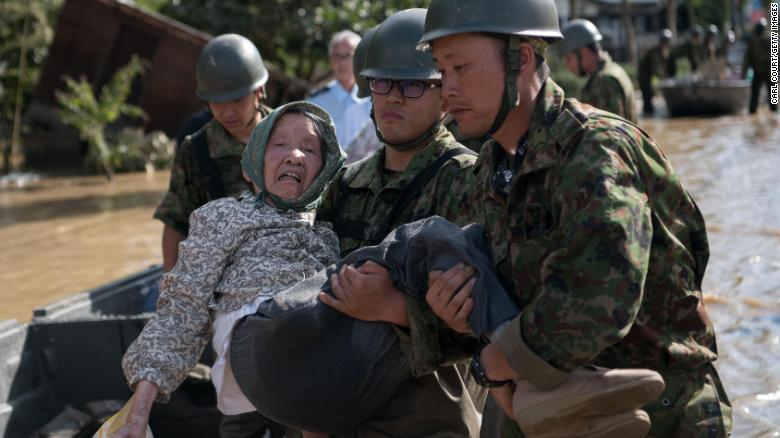
Jakarta, CNN Indonesia — Gelombang panas dilaporkan menewaskan setidaknya 14 orang selama libur panjang akhir pekan di Jepang. Suhu tinggi sekaligus menghambat pemulihan di wilayah terdampak banjir di mana lebih dari 200 orang meninggal dunia pekan lalu.
Temperatur pada Senin (16/7), yang merupakan hari libur nasional Jepang, meroket hingga 39 derajat celsius di sejumlah area yang jauh dari pesisir, kata Badan Meteorologi Jepang (JMA) dikutip Reuters, Selasa (17/7). Kelembaban tinggi memperparah keadaan dan membuat kondisi berbahaya.
Sejumlah media melaporkan setidaknya 14 orang tewas selama libur panjang, termasuk seorang perempuan berusia 90-an yang ditemukan tak sadar di sebuah lapangan. Ratusan lainnya dirawat di rumah sakit karena kondisi terkait panas.
Panas paling terasa di daerah yang tak memiliki pesisir seperti perfektur Gifu, di mana suhu bisa mencapai 39,3 derajat celsius pada Senin.
Temperatur di wilayah terdampak banjir mencapai 34,3 derajat celsius pada Selasa siang, menciptakan kondisi berbahaya bagi personel militer dan relawan yang membersihkan lumpur serta reruntuhan.
“Sangat panas. Yang bisa kita lakukan adalah terus minum air,” kata seorang lelaki di Okayama kepada NHK, dikutip Reuters.
Temperatur 35 derajat ke atas tercatat di 200 lokasi sekitar Jepang pada Minggu, kata JMA. Keadaan ini tak biasa terjadi pada Juli, meski sudah pernah sebelumnya.
Kejadian yang sama dilaporkan dari 213 lokasi dalam satu hari pada Juli 2014.
Tahun lalu, 48 orang meninggal dunia karena panas antara Mei dan September, 31 di antaranya pada Juli, menurut Badan Penanggulangan Kebakaran dan Bencana.
Gelombang panas saat ini terjadi akibat lapisan dua sistem tekanan tinggi di sebagian besar wilayah Jepang. JMA menyatakan keadaan ini diperkirakan berlanjut sepanjang pekan atau lebih lama.
It is wildfire season in Oregon, and the U.S. Forest Service warns this year could be especially significant for wildfires. Better Business Bureau Northwest + Pacific and the Oregon Office of Emergency Management are reminding consumers and businesses owners to do their part to be prepared in the event of a natural disaster.
“A major disaster can pose significant challenges for individuals and families, as well as for local businesses” says Andrew Phelps, director at OEM. “Even a minor emergency can interfere with your ability to operate or require funding for repairs. There are steps you and your organization can take to be prepared, the most significant of which is to be 2 Weeks Ready.
While strangers will reach out to help others during a natural disaster, scammers make situations worse by trying to take advantage of victims. BBB reminds those affected by natural disasters to beware of out-of-town contractors soliciting businesses with ill intentions.
While they may not all be frauds, they may lack the proper licensing for your area, offer quick fixes or make big promises they can’t deliver. The con artists typically show up after a natural disaster offering to help with cleanup for a low cost. Be sure to research any company before doing business with them and never be pressured into making quick decisions when solicited by a contractor.
Remember, it’s just as important to be prepared before disaster strikes. Here are some steps you can take to get your home and business ready:
For consumers:
Keep documents secure. Store your documents in a safe place that is easy to access such as a safe deposit box. This includes your Social Security card, birth certificate, passport and any other official, hard-to-replace documents. Documents not kept in a safe can land in the wrong hands.
Have a plan. Familiarize yourself with your town’s emergency plans for shelter and evacuation. Have a list of emergency contacts, the locations frequented by family members and know the specific needs of household members, including animals.
For additional consumer preparedness information, visit the Individual Preparedness page on OEM’s website.
For businesses:
Practice emergency drills. Businesses should practice drills with employees and have processes in place to account for employees in the event of a disaster.
Lock up customers’ information. Remember to safeguard your customers’ privacy by protecting their data. Lock up important papers or transfer them to the cloud to keep them safe and intact.
For additional business preparedness information, check out the Business Preparedness section on OEM’s website and complete a Preparedness Scorecard for Businesses. Get more scam tips at bbb.org/scamtips.
Trump’s FEMA wasn’t ready for last year’s record-breaking hurricane season, and it wants the public to know that it’s not ready for another one.
The Federal Emergency Management Agency was already supporting 692 federally declared disasters when hurricane season started last year. Then came the most destructive disaster season in U.S. history, causing $265 billion in damage and forcing more than a million Americans from their homes. FEMA was overwhelmed. Most Popular So the agency has a novel suggestion for Americans as the 2018 disaster season heats up: Don’t rely on us.
In a report last week evaluating its response to last year’s disaster, FEMA details “how ill-prepared the agency was to manage a crisis outside the continental United States, like the one in Puerto Rico,” The New York Times reported. “And it urges communities in harm’s way not to count so heavily on FEMA in a future crisis.”
“The work of emergency management does not belong just to FEMA,” the agency stated near the end of the report. “It is the responsibility of the whole community, federal, [state, local, tribal and territorial governments], private sector partners, and private citizens to build collective capacity and prepare for the disasters we will inevitably face.”
The sentiment echoes President Donald Trump’s own comments about Puerto Rico last year, following the devastation wrought by Hurricane Maria.
Still, it’s probably good advice, because thousands of people who depended on FEMA for help last year are still struggling. They include 83-year-old Rosalea Nall, who lived in a hotel for eight months after her Texas home was flooded during Hurricane Harvey. Last week, she had to move back into her gutted house after FEMA stopped providing housing vouchers for Harvey victims. They also include the more than 1,700 Puerto Rican refugees of Hurricane Maria, currently living in hotels on the mainland, whose housing assistance is set to expire on July 23 (and which would have expired on June 30, but for the grace of a federal judge). Meanwhile, approximately 1,000 people in Puerto Rico remain without electricity.
FEMA acknowledged many of its failures in last week’s report—notably that it emptied emergency supplies from a Puerto Rico warehouse just days before Maria hit. (The supplies were sent to the U.S. Virgin Islands, then reeling from Hurricane Irma.) As USA Today put it, the agency admitted its planning “was incomplete, did not adequately account for the possibility of multiple major disasters in a short amount of time, and underestimated the impact of ‘insufficiently maintained infrastructure’ in Puerto Rico.”
But FEMA also argued that an effective response was near-impossible given its resources. “FEMA entered the hurricane season with a [workforce] less than its target, resulting in staffing shortages across the incidents,” the report read. The agency has approximately 10,000 employees, but last year’s hurricanes and wildfires “collectively effected more than 47 million people—nearly 15 percent of the Nation’s population.”
Nearly 5 million households registered for FEMA assistance in 2017—more than the previous 10 years combined, and more than all who registered for assistance from hurricanes Katrina, Rita, Wilma, and Sandy combined. The wildfires in California were their own behemoth, requiring more federal response contracts than Hurricanes Harvey and Irma combined. FEMA’s response to Hurricane Maria was also “the longest sustained air mission of food and water delivery in FEMA history,” according to the report. Hurricane Irma was “one of the largest sheltering missions in U.S. history,” with 6.8 million people under evacuation order. Eighty percent of the households impacted by Hurricane Harvey did not have flood insurance, either, contributing to FEMA’s high costs.
FEMA thus was only able to pay for less than 10 percent of the destruction. Hurricanes Harvey, Irma, and Maria caused a combined $265 billion in damages, according to the report. Yet as of April 30, FEMA had only obligated $21.2 billion toward those damages.
The agency offered several recommendations for improving FEMA’s capability for this year’s disaster season, which is already underway. It suggested, for example, “enhancements to the planning process” when collaborating with state and local governments before disasters. FEMA essentially echoed the message from its planning report in February: “The most important lesson from the challenging disasters of 2017 is that success is best delivered through a system that is Federally supported, state managed, and locally executed.”
FEMA is certainly correct that disasters must be managed at all levels, but the most important lesson of the 2017 disaster season is that weather disasters are becoming more frequent and more damaging. The government’s failure to grapple with that reality contributed to FEMA’s poor response. For example, the 1988 Stafford Disaster Relief and Emergency Assistance Act—the law that gave FEMA its authority to coordinate disaster relief efforts—ensured that the agency could only re-build Puerto Rico’s weak electricity system after it was wiped out by Maria; it was not allowed to spend money on rebuilding a more resilient electricity system.
FEMA could have suggested a change in that law in its after-action report. And yet, just as the agency failed to mention climate change in its February report, it failed to do so in last week’s report. Extreme weather is getting more extreme, and until FEMA recognizes and acts on that reality, it will find itself overwhelmed indefinitely.
In early November 2017, Brooks Fisher’s neighbor in Sonoma, California, pounded on his door at 2 a.m., rang the doorbell and shouted, “There’s a fire coming and you need to get out now! I can hear trees exploding!”
The sky was orange and the smell of smoke was strong. Fisher and his wife jumped in their car and drove out as flames engulfed houses on both sides of the road. Brooks called 911: The dispatcher told him she already had reports of fires on Rollo Road, but he and his wife saw no official responders. The only people trying to help evacuate the area were their neighbors, going door to door.
When Brooks and his wife finally returned to their home, all they found were ashes. But they were safe.
Brooks and his family survived thanks to intervention by a concerned neighbor. Many deaths that occur during events such as flooding, fires, hurricanes and mudslides could be prevented by leaving vulnerable areas. But people don’t always move, even after receiving evacuation orders or warnings of imminent risk.
To understand why, we worked with Facebook to understand evacuation patterns based on information that people shared publicly on social media before, during and after hurricanes. We found that social networks, especially connections to those beyond immediate family, influence decisions to leave or stay in place before disasters.
Insights from social media
Many communities that are vulnerable to disasters put a lot of resources into providing residents with early warnings. For example, in Montecito, California, during the January 2018 mudslides, local authorities and disaster managers tried to warn residents through channels that included emails, social media alerts, press releases and deputies going door to door. Despite these efforts, not all residents evacuated and nearly two dozen lost their lives.
Traditionally, much emphasis has been placed on the role of physical infrastructure preparedness during crisis. But in light of findings about the importance of social capital during crises, our team wanted to better illuminate human behavior during these events.
To understand evacuation behavior, social scientists have typically asked survivors weeks or even years after an event to recall what they did and why. Other researchers have waited at rest stops along evacuation routes and directly interviewed evacuees fleeing oncoming hurricanes or storms. We wanted to better capture nuances of human behavior without having to rely on memory or catching people as they stopped for gas and coffee.
To do so, we worked alongside researchers from Facebook using high-level, aggregated and anonymized summaries of city-level data before, during and after a disaster to construct the outcome variables “Did you evacuate?” and “If you did, how soon after the disaster did you return?” Facebook engages in numerous academic collaborations across engineering, business and research disciplines. We believe that our research team is among the first to study the movement of so many people across multiple disasters using geolocation data.
To protect user privacy, we submitted our research design to a rigorous internal review by specialists in data science, law, privacy and security. We only reported overall associations in the study population and used geolocation data no more specific than the city level. And our models only incorporated features grouped into broad categories – for example, “Age group 35-44,” rather than any person’s precise age.
Tight local networks may encourage staying put
Based on research showing that social ties provide resilience to people during crises, we suspected that social capital might be a critical factor in helping people decide whether to stay or go. By social capital, we mean people’s connections to others and resources available to them through their social communities, such as information and support.
Some aspects of these resources are reflected through social media. With this in mind, we set out to study whether attributes of people’s social networks impacted evacuation behavior.
Visualizing the exodus of Miami-area residents in the days prior to Hurricane Irma’s landfall. Each dot represents an aggregate group of users within 0.5 latitude/longitude degrees, colored by evacuees (in blue) and non-evacuees (in red).
We looked at three different types of social ties:
Bonding ties, which connect people to close family and friends
Bridging ties, which connect them through a shared interest, workplace or place of worship
Linking ties, which connect them to people in positions of power.
While our research is currently being revised for resubmission to a peer-reviewed journal, we feel comfortable arguing that, controlling for a number of other factors, individuals with more bridging ties and linking ties – that is, people with more connections beyond their immediate families and close friends – were more likely to evacuate from vulnerable areas in the days leading up to a hurricane.
We theorize that this happens for several reasons. First, people with more bridging ties have far-reaching social networks, which may connect them to sources of support outside of areas directly affected by disasters. Second, people with more bridging ties may have built those networks by moving or traveling more, and thus feel more comfortable evacuating far from home during a disaster.
Linking ties are also important. Our data showed that users whose social networks included following politicians and political figures were more likely to evacuate. This may be because they were more likely to receive warning information and trust authority figures disseminating that information.
In contrast, we found that having stronger bonding ties – that is, family and friends – made people less likely to evacuate leading up to a hurricane. In our view, this is a critical insight. People whose immediate, close networks are strong may feel supported and better-prepared to weather the storm. And staying in place could have positive outcomes, such as a higher likelihood of rebuilding in existing neighborhoods.
Limerick at the Half Shell Raw Bar in Key West, Florida, during evacuation for Hurricane Ivan, Sept. 11, 2004.Dale M. McDonald, CC BY-ND
But it is also possible that seeing relatives, close friends and neighbors decide not to evacuate may lead people to underestimate the severity of an impending disaster. Such misperceptions could put people at higher immediate risk and increase damage to lives and property. Whether people whose stronger bonding ties lead them to stay fare better or worse than others is a question for further study.
Climate change and coastal development are making disasters more frequent and damaging. Social science and social media, which are a critical part of disaster toolkits, offer opportunities to tackle critical questions about factors that can make communities and societies more resilient to disasters and crises.
Sonoma resident Brooks Fisher and Paige Maas, a data scientist at Facebook, contributed to this article.
batampos.co.id – Dinas Sosial Pemberdayaan Perempuan Perlindungan Anak dan Pemberdayaan Masyarakat Desa (Dinsos P3APMD) Kabupaten Kepulauan Anambas (KKA) menggandeng Tagana daerah itu membentuk Kampung Siaga Bencana. Ini bertujuan mengoptimalkan penanggulangan bencana melalui peningkatan partisipasi masyarakat sebagai salah satu pelaku utama penanggulangan bencana. Supriadi Kepala Bidang Dinsos P3APMD mengatakan, kampung siaga ini terdiri dari empat desa di Kecamatan Jemaja Timur. Yakni Desa Genting Pulur, Desa Bukit Padi, Desa Ulu Maras dan Desa Kuala Maras.
Menurutnya, launching kampung siaga bencana dilaksanakan pada Sabtu (14/7) kemarin. “Launching dilakukan Asisten Administrasi Pemerintahan Umum (Asisten III, red) Yendi, MM,” ungkapnya.
Sebelum dilantik, para pengurus dari perwakilan empat desa tersebut diberikan Bimtek selama dua hari pada 12 sampai 13 Juli di Kecamatan Jemaja Timur. Usai melaksanakan launching Kampung Siaga bencana lanjut Supriadi, pihaknya melaksanakan Bakti Sosial (Baksos) penghijauan dengan menanam pohon di Desa Genting Pulur dan Desa Ulu Maras.
”Pohon itu didapatkan dari UPTD Balai Benih Induk Pertanian Dinas Ketahanan Pangan, Pertanian dan Kesehatan Hewan Provinsi Kepri yang difasilitasi Dinas Lingkungan Hidup Provinsi Kepri,” ujarnya.
Kasi Perlindungan dan Jaminan Sosial (Dinsos P3APMD) Yohan Bahtera Adam, mengatakan, kampung siaga bencana dibentuk di Jemaja Timur karena belum ada di Jemaja Timur. Padahal kecamatan tersebut rentan terjadinya bencana seperti banjir dan tanah longsor.
Pihaknya mengucapkan terimakasih kepada semua pihak yang telah membantu ada barang-barang dilumbung sosial seperti Dinas Sosial Provinsi Kepri, serta pihak lain seperti Primer Oil, BSM Cabang Tarempa, Bank Riau Kepri, dan semua pihak yang mendukung suksesnya kegiatan ini. (sya)
Sebuah prestasi berhasil ditorehkan Lembaga Penanggulangan Bencana Muhammadiyah (Muhammadiyah Disaster Management Center/MDMC) di kancah internasional. Lembaga asal Indonesia ini berhasil menjadi juara pertama dalam kompetisi poster internasional di San Diego, Amerika Serikat, Sabtu (14/7).
Ajang yang diselenggarakan dalam rangka Konferensi Pengguna Geographic Information System (GIS) itu dihadiri 18 ribu peserta dari 100 negara. Untuk kompetisi ‘Map Gallery’ sendiri diikuti 1.075 peserta.
MDMC diwakili oleh Ahmad Muttaqin Alim dan didukung oleh perusahaan penyedia layanan GIS, Esri Indonesia. Lembaga ini menjadi pemenang dalam kategori ‘People’s Choice’ berdasarkan voting, di mana mereka mendapatkan lebih dari 400 ribu vote.
Lembaga Penanggulangan Bencana Muhammadiyah juarai kompetisi internasional (Foto: Dok. MDMC)
Sebuah prestasi berhasil ditorehkan Lembaga Penanggulangan Bencana Muhammadiyah (Muhammadiyah Disaster Management Center/MDMC) di kancah internasional. Lembaga asal Indonesia ini berhasil menjadi juara pertama dalam kompetisi poster internasional di San Diego, Amerika Serikat, Sabtu (14/7).
Ajang yang diselenggarakan dalam rangka Konferensi Pengguna Geographic Information System (GIS) itu dihadiri 18 ribu peserta dari 100 negara. Untuk kompetisi ‘Map Gallery’ sendiri diikuti 1.075 peserta.
MDMC diwakili oleh Ahmad Muttaqin Alim dan didukung oleh perusahaan penyedia layanan GIS, Esri Indonesia. Lembaga ini menjadi pemenang dalam kategori ‘People’s Choice’ berdasarkan voting, di mana mereka mendapatkan lebih dari 400 ribu vote.
Dalam siaran pers yang diterima kumparan, Ketua MDMC Pimpinan Pusat Muhammadiyah, Budi Setiawan, menyampaikan bahwa penggunaan teknologi informasi dalam kebencanaan adalah sebuah keniscayaan.
“MDMC meski pun belum secara menyeluruh menggunakan teknologi tersebut, sudah sangat merasakan manfaatnya. Apalagi dengan berkembangnya teknologi GIS (Geographic Information System) dapat secara cepat mengetahui adanya bencana alam secara dini dan akurat,” jelas Budi.
Selain itu, teknologi informasi spasial juga penting untuk dikembangkan karena dapat menunjukkan titik lokasi suatu bencana secara cepat. “Lokasi yang dimaksud bukan hanya lokasi bencana, tetapi juga lokasi tempat-tempat vital, serta titik pergerakan relawan beserta data. Sehingga koordinasi dan komunikasi bisa dilakukan dengan cepat,” paparnya
Keikutsertaan MDMC dalam pengiriman poster pada Konferensi Pengguna GIS di San Diego disebut sebagai tanda kesiapan dari lembaga tersebut dalam memanfaatkan teknologi GIS.
Budi sendiri ingin mendorong kerja sama antara MDMC dengan Esri Indonesia dan perguruan tinggi untuk penggunaan teknologi informasi spasial, dan pembuatan POS koordinasi berbasis GIS.
REPUBLIKA.CO.ID, SLEMAN — Sambaran petir cukup sering terjadi di Kabupaten Wonosobo. Tapi, data-data bencana sambaran petir di Kabupaten Wonosobo hingga kini terbilang masih terbatas.
“Sementara, di sana sering terjadi bencana sambaran petir tahun lalu yang menewaskan beberapa petani dan pendaki gunung,” kata salah satu peneliti Universitas Gadjah Mada (UGM), Gagad Nur Ridho, Senin (16/7).
Gagad mengatakan, kejadian sambaran petir di Kabupaten Wonosobo tidak cuma berdampak negatif bagi manusia. Sebab, sambaran petir turut menyebabkan kerusakan pada bangunan dan lingkungan.
Berawal dari situ, Gagad bersama Abdi Rahmanu dan Astry Zulky Permatasari berusaha meneliti dan menganalisis kerapatan sambaran petir. Utamanya, untuk meminimalisir dampak negatif akibat sambaran petir.
Penelitian dilakukan dengan mengaitkan kejadian sambaran petir dengan bentuk lahan di Kabupaten Wonosobo. Penelitian menggunakan data sambaran petir tipe Cloud to Ground (CG) 2015-2017 dari BMKG Mlati, DIY.
Data diolah memakai ArcGIS 10,3 dengan permodelan Kernel Density, lalu dianalisis secara kuantitatif-kualitatif. Sedangkan, peta bentuk lahan, litologi dan jenis tutupan lahan.
Data itu diperoleh dari Bappeda Wonosobo, yang diuji akurasi menggunakan pengamatan lapangan secara langsung. Hasil menunjukkan Kabupaten Wonosobo terdiri dari bentuk lahan vulkanik dan struktural.
Bentuk lahan vulkaniknya dipengaruhi aktivitas gunung api, sedangkan bentuk lahan strukturalnya dipengaruhi aktivitas tektonik lempeng bumi. Dominan batuannya berupa breksi, lava dan tuff.
Menurut Gagah, itu yang berpengaruh terhadap banyaknya sambaran petir. Hal ini dikarenakan batuan-batuan tersebut memiliki nilai resistivity yang dirasa cukup rendah.
“Kecamatan Kepil dan Kecamatan Wonosobo merupakan wilayah yang memiliki resiko sambaran petir paling tinggi di Kabupaten Wonosobo,” ujar Gagad.
Guna mengurangi resiko jatuhnya korban jiwa dan kerugian material, Gagad menekankan pentingnya penerapan mitigasi bencana. Hal itu dapat dilakukan dengan memasang penangkal petir dan mencabut instalasi listrik.
Selain itu, pengurangan dapat dilakukan dengan segera mengakhiri kegiatan di luar rumah ketika awan Cumulonimbus mulai muncul. Tentunya, dapat dilakukan pula dengan berteduh di bangunan-bangunan permanen.
Data hasil penelitian itu telah disosialisasikan di hadapan pegawai, dan relawan dari BPBD Kabupaten Wonosobo. Apresiasi turut disampaikan Humas BPBD Kabupaten Wonosobo, Sulthoni.
“Pemetaan sambaran petir di Kabupaten Wonosobo yang dilakukan teman-teman cukup unik dan menarik karena jarang dilakukan dan sangat bermanfaat untuk menambah pengetahuan masyarakat terkait sambaran petir,” kata Sulthoni.
HIROSHIMA (Kyodo) — Hundreds of thousands of people in western Japan affected by devastating floods and landslides on Wednesday continued to struggle with water outages, while the death toll of the country’s worst rain-related disaster in decades climbed to 176 with scores more still missing.
At least 254,084 homes are still cut off from the water supply in Hiroshima, Ehime and Okayama, the prefectures hit hardest by last week’s torrential rains, according to the welfare ministry.
About 1,100 homes in other nine prefectures, including Osaka, Yamaguchi and Tokushima, are also without water and there are no prospects of the supply being restored, the ministry said.
Many of those who managed to evacuate have relied on water supplied by local municipalities and the Self-Defense Forces.
Fourteen cities and towns in Hiroshima Prefecture have been affected by water cut-offs following a number of mudslides that caused burst water pipes and power outages at distribution reservoirs.
In the city of Kure, where more than 10 people died, water was distributed at schools and other public facilities after a center managing the water supply was destroyed by mud and sand. The suspension has affected around 93,000 homes, most of the city’s residents.
Masakazu Furusho, 65, was one of many residents who came to a water distribution point at an elementary school in Kure.
“I have to go back and forth between my home and the school three times a day,” he said, adding he wants to know when the water system will be restored.
In Ehime Prefecture, water supply facilities were destroyed in nine municipalities, affecting some hospitals, with local officials saying they are yet to fully grasp the extent of the damage
Some municipalities in Okayama Prefecture, including Kurashiki and Takahashi, are still finding it difficult to supply drinkable water as purification plants were submerged by the flooding.
Susumu Nakano, the head of the Research Center for Management of Disaster and Environment at Tokushima University, said water facilities are often located close to rivers and they are vulnerable to floods.
“Compared to earthquakes, there are not enough measures,” he said. “It is necessary to make efforts on the assumption that there will be flooding.”
Tokyo (CNN)Landslides and flooding caused by torrential rain in Japan have killed another 21 people in what has become one of the deadliest natural disasters to hit the country since the earthquake and tsunami at Fukushima in 2011. A total of 176 people have been killed since the downpour began late last week, Japanese Chief Cabinet Secretary Yoshihide Suga said Wednesday. Another nine are missing.
Some 75,000 responders have been deployed to the area for search and rescue operations. Suga warned that thunderstorms and landslides in the coming hours could pose further danger.
Japanese Prime Minister Shinzo Abe was in Okayama Prefecture Wednesday morning, surveying the damage in one of the hardest-hit areas. He viewed the damage from above in a helicopter and visited an evacuation center. He’s expected to visit the devastated city of Kurashiki and meet with the Okayama governor later Wednesday.
Abe canceled a trip to Belgium, France, Saudi Arabia and Egypt to focus on disaster relief efforts.
Hundreds of thousands of people were forced to flee their homes, and those unable to leave took shelter on rooftops during the heavy flash flooding that hit the country’s streets.
Japanese public broadcaster NHK reported about 364 millimeters (14.3 inches) of rain fell between 5 a.m. and 7 a.m. Sunday in the city of Uwajima — approximately 1.5 times the average monthly rainfall for July.
In Sukumo City in Kochi prefecture, 263 millimeters (10.3 inches) of rain fell in two hours, NHK said. More than 20,000 people were killed or went missing during the Fukushima disaster, when a 9.0-magnitude earthquake hit Japan, triggering a tsunami and nuclear meltdown at the Fukushima nuclear plant.
source: CNN’s Jessie Yeung contributed to this report
PADEMANGAN – Menteri Sosial RI, Idrus Marham menjamin setiap keluarga atau korban dari sejumlah bencana yang belakangan terjadi mendapatkan bantuan dan kehadiran dari negara.
Hal itu diungkapkan dirinya setelah delapan hari mengunjungi semua wilayah bencana yang terjadi di Indonesia.
Menurutnya hal itu dilakukan berdasarkan perintah langsung dari Presiden RI, Joko Widodo yang mengatakan pemerintah harus hadir dan memastikan seluruh anak bangsa mendapat perhatian.
“Selama delapan hari saya kunjungi semua daerah bencana. Semua sudah ditangani sesuai arahan pemerintah Jokowi bahwa bencana tuntas ditangani, negara harus hadir, representatif dari negara itu adalah pemerintah, dan pastikan semua anak bangsa yang terdampak harus diurus semua,” kata Idrus, Selasa (10/7/2018).
Ia menuturkan, di kawasan Gunung Merapi, Jawa Tengah pihaknya telah mencatat daerah yang akan terkena dampak dan sudah membentuk kampung siaga bencana.
Kemudian di Gunung Agung, Bali, dirinya telah menggerakkan banjar-banjar sebagai tempat konsentrasi pengungsi serta menjadi titik pemberian bantuan.
Kementerian Sosial juga telah memberikan bantuan sebesar Rp 15 juta pada 36 keluarga korban meninggal yang diakibatkan karamnya KM Lestari Maju di perairan Selayar, Sulawesi Selatan.
Nominal serupa juga telah diberikan pihak Idrus kepada keluarga dari korban kecelakaan KM Sinar Bangun di Danau Toba, Sumatera Utara yang merenggut banyak jiwa.
Tidak terkecuali bagi korban Gunung Sibanung, Sumatera Utara, pihaknya telah menggelontorkan dana sebanyak Rp 6,9 miliar untuk bantuan relokasi tahap ke tiga.