Flood and wildfire review calls for better communication with First Nations

An independent review into last year’s devastating wildfires and floods in B.C. has found better communication and coordination is needed with First Nations communities.

The report makes more than 100 recommendations on how the B.C government can improve its response to natural disasters.

Many of the recommendations address issues such as the need to include Indigenous communities as true partners during planning and decision making.

“We are not just a community or a stakeholder. We are governments equal to local, provincial and federal governments,” said report co-author Chief Maureen Chapman of the Skawahlook First Nation.

“Making those alliances across whatever boundaries people create, whether it is municipalities or cities or reserve lines, is something that needs to  be set aside.”

The report also calls on governments to build cultural sensitivity training and awareness of racism and discrimination into emergency management plans and to encourage the integration of traditional knowledge.

Better preparation

The report also notes there is a growing gap between the amount of money the province spends on responding to disasters and the funds available for prevention.

A multi-year prevention strategy is needed, said report co-author George Abbott, a former Liberal MLA.

“I salute what government has done and what government is doing, but we have, I think, given the magnitude of the challenge a significantly long way to go yet,” he said.

Some of the other 108 recommendations include:

  • a re-evaluation of all 200-year return-period flood elevations
  • steps to reduce the vulnerability of structures to fires
  • establish centres of excellence in interior locations to support large-scale disaster response
  • build a ‘one-stop-shop’ emergency communications website
  • mandate the insurance industry to create an incentive program to encourage a proactive approach to emergency preparedness

Provincial officials say there is no estimate on what it would cost to implement all 108 recommendations in the report.

But 19 of the recommendations have been addressed based on internal reviews by ministries into last summer’s wildfire and flood response, said Forests, Lands and Natural Resources Minister Doug Donaldson.
 

A record-breaking season

The province spent $550 million fighting the wildfires, which displaced 65,000 people and destroyed 1.2 million hectares of forest.

No lives were lost, but some residents questioned whether officials did enough to save homes.

The review was conducted by George Abbott, a former B.C. Liberal MLA and Maureen Chapman, a hereditary chief of the Skawahlook First Nation.

They held community consultations and toured damaged areas of the province. 

The remains of mobile homes destroyed by wildfire in Boston Flats as a fire burned on a mountain east of Cache Creek, B.C., on Sunday July 9, 2017. (Darryl Dyck/Canadian Press)

Independent review necessary

Individual government ministries also conducted their own reviews.

But an independent report was called for because of the severity of the situation, said Doug Donaldson, the minister of Forests, Lands and Natural Resources.

“We had internal reports done about how the government responded to these situations and we just felt with the scope and scale of what was experienced that an independent report was justified as well,” he said.

The 2017 fires were preceeded by severe flooding in the B.C. Interior. Communities such as Cache Creek, Kelowna, Vernon and Dawson Creek were hit hard.

The fires and floods combined resulted in the largest claim in history — estimated at $400 million — under Canada’s Disaster Financial Assistance Arrangements.

An RCMP officer stands on the road in the Williams Lake area. The entire city was placed under an evacuation alert during the 2017 wildfires. (CBC)
Bantuan Tunai Bencana Alam Ditransfer ke Rekening Korban

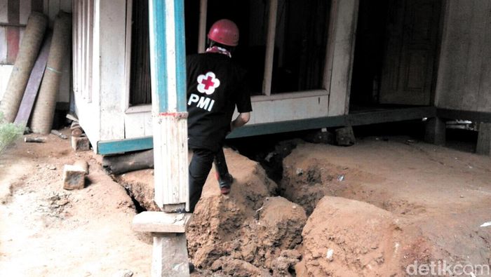
Foto: Bencana retakan tanah di Sukabumi/ Alamsyah detikcom

Jakarta – Pemerintah menyelenggarakan bantuan korban bencana dalam bentuk tunai lewat program transfer tunai (PTT).Program ini sendiri diinisiasi oleh Kementerian Sosial dan Palang Merah Indonesia (PMI).

Bantuan akan diberikan dalam bentuk uang yang ditransfer ke rekening korban. Bagaimana caranya?

Ketua Bidang Penanganan Bencana PMI Sumarsono mengatakan sebelum bantuan ditransfer ke rekening korban, maka akan dilakukan penilaian atau assessment terlebih dahulu. Hal itu sebagaimana prosedur pada umumnya dalam membantu korban bencana alam.

“Kita sebelum bantu kan ada assessment namanya. Jadi (dinilai) siapa yang perlu dibantu. Tidak semua orang,” katanya di Hotel Millenium, Jakarta, Selasa (8/5/2018).

Jadi seandainya hanya ada 200 orang yang bisa dibantu, sementara yang jadi korban bencana lebih dari itu, maka akan dilakukan penilaian siapa yang bakal diprioritaskan lebih dulu.

“Ya disesuaikan misalnya contohnya kita assasment-nya lengkap, kita bisa bantunya misalnya 200 orang. Padahal korbannya sekian orang. 200 orang itu yang paling mendesak yang paling jadi prioritas,” jelasnya.

Dia juga mencontohkan bantuan perbaikan rumah korban bencana alam, dari banyaknya rumah yang rusak belum tentu semuanya dapat bantuan. Jadi diprioritaskan dengan melihat penghuni rumah tersebut.

“Kita hanya bisa bantu di kompleks perumahan itu hanya entah 50-75 rumah (misalnya). Karena duitnya hanya itu (terbatas), ada ini ‘loh ini kok rusaknya sama, yang ini kamu bantu’, oh enggak, yang ini kebetulan punya anak kecil, yang ini masih pengantin remaja, misalnya gitu,” terangnya.

Proses assesment ini pun melibatkan perbankan, dalam hal ini bank nasional. Setelah dilakukan proses tersebut dan korban memenuhi penilaian, baru kemudian bantuan ditransfer ke rekening masing-masing korban yang sebelumnya sudah didata nomor rekeningnya.

“Assessment kita bersama dengan bank. Begitu bencana kan kita tahu yang diassasment-nya,” tambahnya. (hns/hns)

Banjir Mendominasi Bencana di Pasuruan Selama 4 Bulan Terakhir

Pasuruan (wartabromo.com) – Kurun 4 bulan terakhir, sebanyak 55 bencana terjadi di Kabupaten Pasuruan. Banjir masih mendominasi, bila disandingkan dengan bentuk bencana lainnya.

Banyaknya bencana tersebut merupakan catatan Badan Penganggulangan Bencana Daerah (BPBD) Kabupaten Pasuruan sepanjang awal tahun 2018 ini.

Bakti Jati Permana, Kepala Pelaksana BPBD Kabupaten Pasuruan mengatakan, bencana paling sering terjadi di Kabupaten Pasuruan adalah bencana banjir, yakni di 40 titik di wilayah Pasuruan bagian Tengah, Timur sampai Barat.

“Karena awal tahun sampai Pebruari adalah tinggi-tingginya curah hujan, sehingga daerah-daerah yang seringkali menjadi langganan banjir, kembali disambangi kiriman air bah,” kata Bakti, Selasa (08/05/2018).

Meski terbilang banyak, jika dibandingkan awal tahun lalu, jumlah bencana banjir lebih sedikit pada awal tahun 2018 ini. Kata Bakti, waktu itu disebabkan adanya El Nino yang menyebabkana curah hujan cukup tinggi, berakibat seringnya banjir di hampir semua wilayah terdampak.

Cuaca ekstrim tahun lalu, jika dibandingkan, bencana banjir tahun ini tetbilang lebih sedikit.

“Catatan sampai bulan April mencapai 40 lokasi di awal tahun ini,” jelasnya.

Banjir paling tinggi terjadi pada 6 Januari 2018, berlangsung sampai 11 Januari Dan ada pula banjir tinggi pada 16-`19 Februari, 22 Februari dan 22-24 Maret. Tercatat banjir terjadi dari Kecamatan Grati, Rejoso, Pohjentrek, Kraton, Bangil, Beji, Gempol, Winongan, Rembang, Nguling sampai Wonorejo.

Sedangkan longsor terjadi hingga 12 kali, mulai di Lumbang, Tutur, Tosari, Puspo dan Kejayan. Untuk Puting beliung yang cukup besar terjadi di Kecamatan Kraton dan Purwosari dan lainnya ada 1 rumah tersapu banjir.

Dari data tersebut, untuk total dana kebencanaan yang sudah digunakan mencapai Rp 400 juta. Jumlah ini adalah untuk keperluan dapur umum seperti nasi bungkus, mie instan, pembelian terpal, sandbag sampai pengiriman air bersih.
Selama bulan Mei ini dikatakan masih masuk musim peralihan dari Hujan ke Kemarau. Namun karena curah hujan sudah rendah dikatakan resiko bencana sudah minim.

“Namun biasanya karena musim peralihan yang terserah stamina tubuh sehingga diharapkan masyarakat bisa menjaga kesehatan,” pungkasnya. (mil/ono)

Disaster Preparedness for Those w/Special Needs

While most disasters can’t be prevented, the stress of such situations can be reduced significantly through personal preparedness. This is particularly important for households with members who have disabilities, functional needs or may need assistance during an emergency.

Throughout May, the Illinois Emergency Management Agency (IEMA) and local emergency management agencies will highlight the importance of disaster preparedness for people with functional and access needs.

“Disasters can cause power outages, force people to evacuate their homes or create other dangerous situations,” said IEMA Acting Director William P. Robertson. “We encourage everyone to be prepared, especially those who may have medical, functional or access needs.”

Robertson said IEMA has information available on the Ready Illinois website (www.Ready.Illinois.gov) to help people and caregivers prepare for emergencies. A guidebook, Emergency Preparedness Tips for Those with Functional Needs, offers preparedness tips for people with visual, cognitive or mobility impairments, people who are deaf or hard of hearing, those who utilize service animals or life support systems, and senior citizens.

For each functional need, the guidebook provides a list of supplemental items for a disaster kit, tips on developing an emergency plan, suggestions on how to be better informed about community emergency planning, and a checklist of preparedness activities.

The Ready Illinois website also offers more than two dozen preparedness videos in American Sign Language on such topics as what to do before, during and after tornadoes, severe thunderstorms and flooding, how to build an emergency supply kit, and what to do if you’re instructed to evacuate.

Hawaii volcano: Aerial views show slow-moving disaster unfolding as lava envelops homes

A volcanic eruption on Hawaii’s Big Island intensified over the weekend, with some people potentially stranded in their homes.  The eruption of Kilauea Volcano on Hawaii’s Big Island has spewed vast amounts of lava for more than three days and nights.

Hundreds of earthquakes have also rocked the area, and more volcanic cracks opened in the ground over the weekend. At least 31 homes and other structures have been destroyed.

About 1,700 people living nearby have been evacuated.

Authorities have locked down the Leilani Estates neighborhood in Pahoa, more than 25 miles from the Kilauea Volcano. No residents are going in right now.

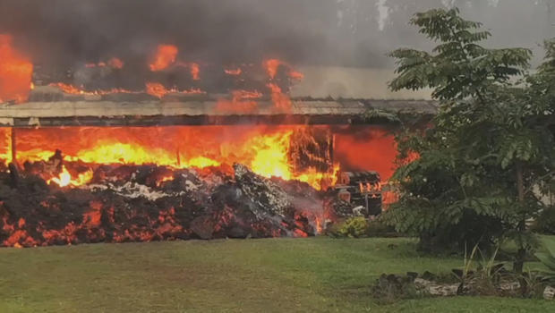
hawaii-volcano-home-destroyed-620.jpg

At least 31 homes and structures have been destroyed.

CBS News

Emergency management sent out a cellphone alert late last night, warning everyone who was still in the neighborhood to get out. But CBS News has learned there are still some people inside, and police say they’re not going in to get them.

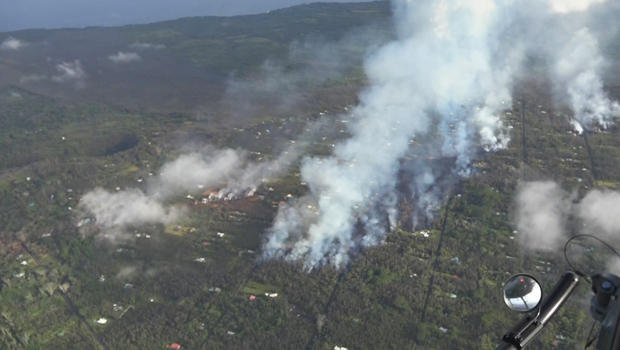
Correspondent Carter Evans got a view of the area flying overhead. From the air, lines of smoke show where lava is flowing through the Leilani Estates as homes continue to burn.

hawaii-volcano-aerial-view-620.jpg

An aerial view of fissures in the Leilani Estates neighborhood on Hawaii’s Big Island.

CBS News

There are no firefighters down there, says Evans, because there’s nothing they can do.

This is an unstoppable force.

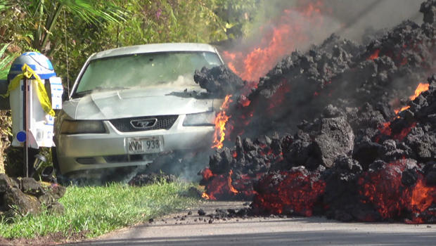
The slow-moving lava has consumed everything in its path, including trees and homes. Even a car was no match for the molten wall.

hawaii-volcano-lava-flow-torches-car-620.jpg

A car is torched by a slow-moving wall of lava.

CBS News

“The eruption progressed a few more extensive flows,” said civil defense administrator Talmadge Magno. “It seems like there’s a lot of magma underground, and there’s no sign of [it] slowing down.”

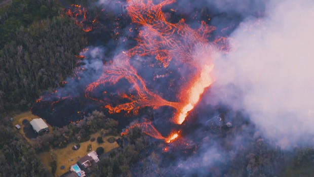
At least 10 fissures have opened up in Leilani Estates. In some cases the eruptions were so violent, lava spewed more than 200 feet in the air.

hawaii-volcano-fissue-aerial-view-paradise-helicopters-620.jpg

An aerial view of a fissure spewing lava at Leilani Estates.

Paradise Helicopters

On Sunday some evacuees were allowed back home to grab essentials. A line of cars waiting to return stretched more than two miles long.

How a Hawaii crater collapse led to latest volcanic eruption

“We choose to live here, but at the same time, yeah, it’s painful, no question,” said evacuee Lori Wada.

Evans asked, “Do you have any idea when you’ll be able to go home again?”

“We don’t even know if our home’s going to be there again,” she replied.

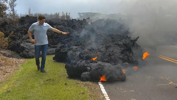
At first glance, it may not look like the mass of lava covering the roadway is moving at all. It’s cooled, and there’s a crust on top, but if you look at the leading edge, it is slowly inching forward.

hawaii-volcano-carter-evans-with-lava-flow-620.jpg

Correspondent Carter Evans with a lava flow at Leilani Estates.

CBS News

Over the weekend, the Big Island was rocked by hundreds of earthquakes, including one measuring magnitude 6.9 — Hawaii’s largest in more than 40 years.

Sam Knox lives about a hundred yards away from one of the eruptions. “It’s like a Goliath, like a roaring jet engine,” he said.

When asked why he chose to stay, Knox replied, “Because this is where I live, right here. I had faith in the gods that my house is going to be OK.”

The lava is showing no signs of slowing down — and that’s just one of the concerns here. Another is the toxic smoke. The lava emits sulfur dioxide, which can be deadly. Authorities say levels of the gas in what they call the “hot zone” are extremely high.

Hawaii’s Big Island Kilauea volcano erupts, evacuations in place

HAWAII’S Big Island has been hit by another big earthquake – this time measuring 6.9 on the Richter scale – shaking up to 10,000 people already forced to evacuate.

It’s the biggest earthquake the volcanic island chain has experienced since 1975.

The earthquake shook Hawaii’s Big Island this morning, prompting fresh eruptions of a volcano that has been spewing lava near residential areas, forcing hundreds of people to flee.

Hawaii’s Fire Department has issued fresh evacuation orders, warning of high levels of sulfur dioxide gas.

The US Geological Survey said the quake struck at 12:32pm local time (2232 GMT) and was centered on the south flank of the Kilauea volcano, which first erupted on Thursday after a series of tremors on the island.

“This is in almost exactly the same location as the deadly 1975 M 7.1 quake,” USGC said in a tweet.

That quake killed two people and injured 28.

Another 5.7-magnitude tremor hit the island earlier on Friday and authorities said they expect more seismic activity.

The quakes have prompted the Kilauea volcano, one of five active on the island, to erupt.

Drone and video footage showed orange magma gushing up from cracks in the ground and snaking through a wooded area.

Molten lava could also be seen bubbling up through cracks on streets in the Leilani Estates and Lanipuna Gardens neighborhood where residents were ordered to evacuate on Thursday.

The area is home to about 1,700 people and 770 structures. The broader district potentially impacted by the threat is home to some 10,000 people.

No injuries have been reported but several homes were said to have been destroyed or badly damaged on Friday, authorities said.

Officials urged any remaining residents to evacuate and warned of extremely high levels of toxic fumes.

“Elderly, young and people with respiratory issues need to comply with the mandatory evacuation order and leave the area,” a statement from the mayor’s office said.

Governor David Ige said residents were being housed in community centers until the danger from Kilauea, one of the world’s most active volcanoes, has passed.

Ige signed an emergency proclamation releasing disaster funds to the Big Island.

East Africa’s deadly floods are a stark reminder of the region’s poor disaster preparedness

Villagers go about their business in a flooded market centre in Kisumu, about 400km west of the capital Nairobi in Kenya on Saturday 30 December 2006. Heavy rains continue to cause havoc in Kenya and parts of East Africa.

Torrential rains have uprooted hundreds of thousands of people across East Africa in recent weeks, offsetting a humanitarian disaster that is threatening the lives of entire communities.

In Kenya, floods have displaced over 260,000 people and killed 100 others in at least 15 of the country’s 47 counties, according to the United Nations office for the coordination of humanitarian affairs. The floods, which have also affected refugees in northeastern Kenya’s Dadaab camp, have damaged businesses, swept away homes and food supplies, closed more than 200 schools, destroyed community water points, and increased chances of disease outbreaks including cholera and malaria. The situation was so dire Facebook activated a safety feature this week asking users to indicate if they were safe.

In Somalia, 500,000 people were affected by the floods, prompting the government to ask for international assistance, and pushing African Union peacekeepers to relocate hundreds of people to safer grounds.

The flooding comes as many countries are just recovering from the devastating drought and famine that swept the Horn and East Africa region in the last two years. The drought, exacerbated by El Nino, curtailed crop production in Kenya, drove food prices higher, increased inflation, and put a strain on economic growth. It also forced over 1.3 million Somalis to leave their homes last year, according to the Norwegian Refugee Council.

The current torrents show the poor planning and the lack of disaster preparedness among governments in the region. As such, countries experience a vicious cycle that alternates between droughts and floods, reacting to events instead of being proactive about attaining solutions.

In the aftermath of rains, for instance, roads are deemed impassable, drainage systems clog, transport networks break down, and rivers burst their banks blocking any humanitarian efforts. Both climatic conditions also exacerbate hunger and poverty, especially among pastoralists, who lose their herds for lack of water during dry periods and are swept away when it pours.

Flood victims are rescued by National Police Service Airwing personnel at the Tana River Delta
Flood victims are rescued by National Police Service Airwing personnel at the Tana River Delta, Kenya (National Police Service via Reuters)

Africa is extremely vulnerable to the impact of climate change compared to other continents. Even while emitting a small number of greenhouse gases, the continent is experiencing droughts, heatwaves, floods, and rising sea levels more frequently. To manage this challenge would require countries to invest in strategic approaches that would understand shortcomings, collaborate with research institutions to better understand climate phenomena, and create models that that would help prepare for and reduce the effects of disasters.

These are efforts and plans better started now—since the rains, at least this time, are not abating anytime soon.

Sign up for the Quartz Africa Weekly Brief — the most important and interesting news from across the continent, in your inbox.

Almost 100 people killed in weeks of flooding in Kenya

At least 100 people have died and nearly 260,000 have been displaced by flooding in Kenya.Rescuers have been working to airlift stranded residents to safety and provide aid to isolated communities after heavy rain and landslides.Marshal Mukuvare, Disaster Management Delegate for the International Federation of Red Cross and Red Crescent Societies (IFRC), said on Friday that the majority of them in Tana River, Kilifi and Mandera counties.

Marshal Mukuvare, Disaster Management Delegate for the International Federation of Red Cross

Marshal Mukuvare, Disaster Management Delegate for the International Federation of Red Cross. Credit: AP


“There has been more rains than people were expecting.”Issues of poor drainage has also affected the flow of water and the seepage.”The flooding has also destroyed homes and properties of people, livestock has also been affected, and crops, because most people were growing crops for the rainy season.”

Rescuers have been working to airlift stranded residents to safety.

Rescuers have been working to airlift stranded residents to safety. Credit: AP


Floods from seasonal rains hit as the East African nation was recovering from a devastating drought last year.Mukuvare said the (IFRC) launched an appeal to provide shelter, food and medical assistance, warning the floods could trigger or worsen outbreaks of diseases such as malaria and cholera.”With this emergency appeal we are looking to support and assist over 150,000 people with shelter, support, distribution of non-food items, some food assistance, water and sanitation services particularly hygiene promotion,” he said.

Turkey floods: Cars swept downstream as heavy rainfall hits Ankara

Rescue workers and people are tending to broken down cars on streets after flooding in Ankara.

A torrential flood has swept through a district in the Turkish capital of Ankara, sending vehicles downstream and damaging local businesses.

The rain was expected to last for three hours on Saturday afternoon (local time), but instead came down in nine minutes, causing flooding in Ankara’s Mamak district.

Ankara’s Mayor, Mustafa Tuna, told local media it was a “natural disaster like never before”.

Four people were injured in the floods, which damaged more than 160 cars and 25 businesses, Turkish Social Security Minister Julide Sarieroglu said.

Footage showed cars and trucks being swept away in fast-moving floodwaters.

One man escaped being submerged by climbing on top of a car caught in the flood, and was seen crouching on the bonnet and riding the vehicle downstream.

The Turkish Red Crescent, a humanitarian organisation, said a team of volunteers were cooking soup for people and crews in the area.

Ms Sarieroglu said the Government was working to assess and alleviate the damage.

DPRD Provinsi Jawa Tengah Desak Pemerintah Tangani Bencana Banjir Bumiayu

PortalPantura.com: Banjir bandang yang melanda Bumiayu terutama di Desa Klierang yang merendam puluhan rumah dan menghanyutkan satu unit mobil dan empat sepeda motor tersebut mendapat perhatian dari anggota DPRD Provinsi Jawa Tengah

Rombongan dari komisi D DPRD Jawa Tengah tersebut meninjau lokasi terdampak banjir Bumiayu seperti jembatan Pandawa yang putus.

Salah satu anggota komisi D DPRD Provinsi Jawa Tengah Wahyudin Noor Aly pihaknya mendesak kepad pemerintah untuk mengajukan secepatnya perbaikan infrastruktur yang rusak.

“Ini kan bencana alam, jadi anggaranya tidak perlu menunggu penetapan ABPD.” Noor usai meninjau jembatan Pandawa Bumiayu, Sabtu (7/4).

Ia mendesak kepada pemerintah provinsi dan kabupaten untuk secepatnya melakukan penanganan. Untuk tebing sungai Kalierang adalah kewenangan provinsi, sedangkan jembatan adalah kewenangan pemerintah kabupaten.

sumber: kumparan.com