Tangkuban Parahu Kembali Mengalami Erupsi Kamis Malam

Tangkuban Parahu Kembali Mengalami Erupsi Kamis Malam

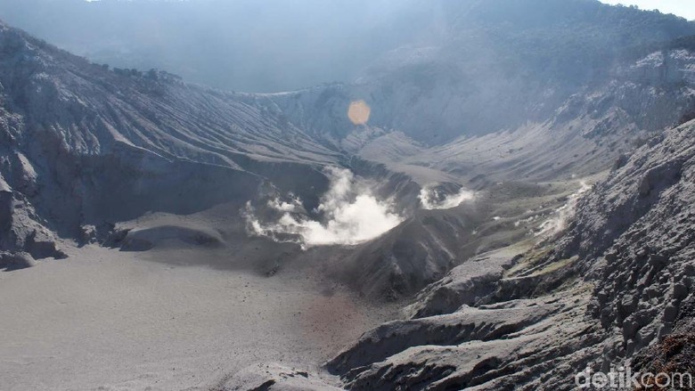
Jakarta, CNN Indonesia — Gunung Tangkuban Parahu, Jawa Barat kembali mengalami erupsi. Berdasarkan informasi yang disampaikan Pusat Vulkanologi dan Mitigasi Bencana Geologi (PVMBG) Pos Pengamatan Gunungapi Tangkuban Parahu, erupsi terjadi pada Kamis (1/8) pukul 20.46. 

Kepala PVMBG Kasbani dalam pernyataan yang dikeluarkannya Kamis malam mengatakan erupsi terjadi dengan tinggi kolom abu teramati sekitar 180 meter dari dasar kawah (sekitar 2.084 meter di atas permukaan laut). Kolom abu teramati berwarna kelabu dengan intensitas tebal condong ke arah utara dan timur.

Ia menyatakan erupsi ini terekam di seismogram dengan amplitudo maksimum 50 mm dan durasi ± 11 menit 23 detik. Ketinggian abu teramati 180 dari dasar kawah. Ia menyatakan dengan erupsi yang terjadi pada Jumat malam ini, status Gunung Tangkuban Parahu ditetapkan pada status level I. 

Dengan status tersebut, pihaknya memberikan beberapa imbauan kepada masyarakat. Pertama, mengimbau masyarakat di sekitar G. Tangkuban Parahu dan pengunjung/wisatawan/pendaki, Tidak mendekati kawah yang ada di puncak G. Tangkuban Parahu dalam radius 500m dari kawah aktif atau sekitaran sepanjang area parkir bibir kawah dan tempat berdagang.

Kedua, meminta masyarakat di sekitar G. Tangkuban Parahu, pedagang, wisatawan, pendaki, dan pengelola Wisata G. Tangkuban Parahu agar mewaspadai meningkatnya konsentrasi gas-gas vulkanik dan dihimbau tidak berlama-lama berada disekitar kawah aktif G. Tangkuban Parahu agar terhindar dari paparan gas yang dapat berdampak bagi kesehatan dan keselamatan jiwa.

Ketiga, mengimbau masyarakat di sekitar G. Tangkuban Parahu, pedagang, wisatawan, pendaki, dan pengelola Wisata G. Tangkuban Parahu agar mewaspadai terjadinya letusan freatik yang bersifat tiba-tiba dan tanpa didahului oleh gejala vulkanik yang jelas.

Tangkuban Perahu Kembali Erupsi, Warga Diminta Tak Mendekati Kawah

Jakarta – Gunung Tangkuban Perahu kembali bererupsi malam ini. Meski status Tangkuban Perahu ditetapkan level I atau normal, warga diminta tidak mendekati area kawah dalam radius 500 meter.

“Masyarakat di sekitar Gunung Tangkuban Parahu dan pengunjung atau wisatawan/pendaki, Tidak mendekati kawah yang ada di puncak Gunung Tangkuban Perahu dalam radius 500 meter dari kawah aktif atau sekitaran sepanjang area parkir bibir kawah dan tempat berdagang,” tulis keterangan KESDM, Badan Geologi PVMBG Pos Pengamatan Gunungapi Tangkuban Perahu, Kamis (1/8/2019).

Masyarakat, pengunjung, hingga pengelola juga diminta mewaspadai meningkatnya konsentrasi gas-gas vulkanik. Selain itu, diimbau tidak berlama-lama berada di sekitar kawah aktif agar terhindar dari paparan gas yang dapat berdampak bagi kesehatan dan keselamatan jiwa.

“Masyarakat di sekitar Gunung Tangkuban Perahu, pedagang, wisatawan, pendaki, dan pengelola wisata Gunung Tangkuban Perahu agar mewaspadai terjadinya letusan freatik yang bersifat tiba-tiba dan tanpa didahului oleh gejala vulkanik yang jelas,” ujarnya.

Gunung Tangkuban Perahu mengalami erupsi pada pukul 20.46 WIB dengan tinggi kolom abu teramati sekitar 180 meter dari dasar kawah atau 2.084 meter di atas permukaan laut. Kolom abu teramati berwarna kelabu dengan intensitas tebal condong ke arah utara dan timur.

“Erupsi ini terekam di seismogram dengan amplitudo maksimum 50 mm dan durasi sekitar 11 menit 23 detik. Ketinggian abu teramati 180 meter dari dasar kawah,” ujarnya.
(idh/fdn)

Status Gunung Tangkuban Parahu Ditingkatkan Jadi Waspada

Jakarta, CNN Indonesia — Pusat Vulkanologi dan Mitigasi Bencana Geologi (PVMBG) Kementerian Energi dan Sumber Daya Mineral (ESDM) menaikkan status Gunung Tangkuban Parahu menjadi Waspada (Level II) dari Normal (Level I). PVMBG mengamati sejumlah peningkatan aktivitas vulkanis.

Peningkatan status Gunung Tangkuban Parahu berlaku mulai Jumat (2/8) pukul 08.00 WIB.

Kepala PVMBG, Kasbani mengatakan, Gunung Tangkuban Parahu mengalami peningkatan aktivitas vulkanik sejak Jumat (26/7). Gunung Tangkuban Parahu mengeluarkan embusan asap dari Kawah Ratu dengan ketinggian 20-200 meter dari dasar kawah.

Lalu, sejak Kamis (1/8) malam, erupsi kembali terjadi. Pada pukul 20.46, tinggi kolom abu teramati sekitar 180 meter dari dasar kawah. Lalu pada Jumat (2/8) dini hari pukul 00.43, erupsi terjadi kembali namun dengan tinggi kolom yang tak teramati.

“Karena ada peningkatan ancaman, maka hari ini, 2 Agustus 2019 mulai jam 8 pagi ini Gunung Tangkuban Parahu dinyatakan statusnya naik dari level 1 Normal menjadi level 2 Waspada,” kata Kasbani dalam jumpa pers di Ruang Monitoring PVMBG, Kota Bandung.

Menurut Kasbani, tercatat sejak Kamis malam terjadi peningkatan aktivitas vulkanik sebanyak 8 kali.

“Sejak malam ada peningkatan yang cukup signifikan, ada beberapa kali erupsi setidaknya ada 4 kali erupsi malam hari dan pada dini hari tadi 4 kali erupsi,” kata Kasbani.

Atas peningkatan status Gunung Tangkuban Parahu, PVMBG merekomendasikan agar masyarakat tidak mendekat sejauh 1.500 meter dari pusat kawah.

“Kami harapkan masyarakat tetap tenang dan mengikuti arahan PVMBG terkait perkembangan Gunung Tangkuban Parahu,” ujarnya.

ADB creates contingent disaster financing for natural disasters

The Asian Development Bank (ADB) disclosed on Thursday that it has created a new financing mechanism to support developing countries in disaster preparedness and response. 

In a statement, ADB said the new contingent disaster financing (CDF) mechanism will strengthen disaster preparedness and provide quick-disbursing budget support following natural disasters.

ADB said the creation of the CDF was approved by ADB’s Board of Directors on Thursday. It aims to support the bank’s Strategy 2030 which aims to increase efforts in tackling climate change and disaster resilience.  

“CDF will provide a quick and flexible source of funds for developing member countries affected by disasters until funds from other sources become available,” said the Director General of ADB’s Strategy, Policy, and Partnerships Department Tomoyuki Kimura. “It will also help promote greater preparedness and risk management in developing member countries prone to disasters.”

The CDF will cover disasters triggered by natural hazards such as typhoons, floods, earthquakes, droughts, and tsunamis. 

It supports essential policy reforms to strengthen disaster preparedness that are to be completed before a natural disaster occurs. Once a CDF is approved for a country, it remains active until a disaster occurs. 

The country can then quickly access the approved financing to help relieve fiscal constraints for urgent relief and recovery efforts. This will prevent disruptive reallocations from priority budget programs.

“Where necessary, CDF disbursements can be accompanied by follow-up assistance through ADB’s other emergency or regular lending instruments to support recovery and reconstruction,” Kimura said.

ADB said the Asia and the Pacific, where its developing member countries are located, is the world’s most natural disaster-prone region. 

Between 2014 and 2017, countries in the region suffered 55 earthquakes, 217 storms and cyclones, and 236 cases of severe flooding, affecting 650 million people and causing about 33,000 deaths, according to the United Nations.

ADB is committed to achieving a prosperous, inclusive, resilient, and sustainable Asia and the Pacific, while sustaining its efforts to eradicate extreme poverty. In 2018, it made commitments of new loans and grants amounting to $21.6 billion.

Japan aims to boost disaster response with more efficient TEC Force

The land ministry is establishing a system to allow for the quick dispatch of workers with civil engineering and other expertise to areas hit by natural disasters, after a succession of torrential downpours and other large-scale calamities hit the nation in recent years.

The Land, Infrastructure, Transport and Tourism Ministry set up an organ in each of its nine regional development bureaus from Hokkaido to Kyushu in the current fiscal year to coordinate the expedited dispatch and training of members of the Technical Emergency Control Force.

 The TEC Force specialist group, which was created to quickly provide technical assistance to local governments affected by large-scale disasters, is tasked with assessing damage and implementing restoration work. It marked its 10th anniversary last year.

As of April, it had 12,654 registered members, many of whom are officials of regional development bureaus.

A total of 80,000 members have so far been sent to areas damaged by more than 90 major disasters, including the Great East Japan Earthquake and tsunami in March 2011.

Reflecting the recent increase in the number of large-scale disasters, members are sent to affected areas roughly 10 times per year, about double the annual figure when the force was established.

At first, the TEC Force provided assistance at the request of local governments, but after the March 2011 disaster, it began offering large-scale support immediately after disasters.

The number of personnel at regional development bureaus has continued to fall, making it difficult for those involved in developing and managing rivers, roads and other forms of infrastructure to concurrently serve as managers of TEC Force members.

To address this, the ministry in April spun off disaster-related sections at the regional bureaus to take charge of the TEC Force members. Each regional bureau now has a specialized team of about 20 for the task.

When a disaster occurs, the team makes the necessary arrangements with local governments, police and fire authorities, the Self-Defense Forces and other organizations or agencies to dispatch TEC Force members. When not responding to a disaster, members conduct training and educational programs.

In a related development, the government will hasten the process for designating seriously damaged areas as being eligible for larger state subsidies in order to facilitate their reconstruction. The ministry believes the swift dispatch of the TEC Force will help facilitate the survey work needed for the designation, ministry officials said.

The ministry is also considering adding specialists from the private sector to the TEC Force, such as engineers with architectural and land-surveying experience.

The TEC Force “needs more members if the possibility of large-scale disasters, such as a quake originating in the Nankai Trough, is taken into account,” a ministry official said, referring to the trough located off the Pacific coast.

The ministry plans to work out a set of specific measures to reinforce the TEC Force, including a new program to train members, starting in fiscal 2020.

This Strange Solar-Powered Drone Could Save You in a Disaster

If you’re ever in a disaster and see a weird-looking aircraft flying overhead, don’t fret — it could be there to help you.

For two years, Chinese aircraft manufacturer OXAI Aircraft Co. has been developing MOZI 2, a fully solar-powered unmanned aircraft it hopes will one day help out in disaster relief situations.

On Saturday, the drone took its maiden flight at an airport in Deqing County — and it appears the test went off without a hitch.

Solar Sells

OXAI Aircraft told Xinhua that MOZI 2 has a wingspan of 15 meters (49 feet) and is powered solely by solar cells. It can reach an altitude of 8,000 meters (nearly 5 miles), with a maximum cruise time of 12 hours at night following eight hours of charging in sunlight.

In addition to contributing to disaster relief scenarios, the solar-powered drone could be useful for reconnaissance missions and communication efforts, OXAI Aircraft told Xinhua — and now that it knows the craft can fly, it can start working toward those applications.

READ MORE: China-made solar-powered unmanned aircraft makes maiden flight [Xinhua]

Banjir Bandang Terjang Parigi Moutong, 5 Rumah dan Rumah Sakit Tinombo Rusak

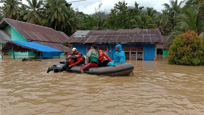
PARIGI, iNews.id – Banjir bandang menerjang Kecamatan Tinombo, Kabupaten Parigi Moutong, Sulawesi Tengah. Bencana itu terjadi setelah hujan deras mengguyur wilayah itu sejak Selasa (30/7/2019) pagi.

Bencana itu juga merusak sejumlah infrastruktur di antaranya Rumah Sakit Raja Tombolotutu Tinombo dan lima rumah warga rusak dihantam banjir.

“Banjir akibat luapan sungai Tinombo karena intensitas hujan cukup tinggi sejak (Selasa) pagi dan puncaknya pukul 13.00 WITA, dampak kerusakan akibat banjir bisa saja bertambah,” kata Kepala Bidang Perlindungan dan Jaminan Sosial Dinas Sosial Parigi Moutong, Ariesto.

Dia menyebutkan, banjir setinggi sekitar 75 centimeter itu merendam sejumlah desa dan Rumah Sakit Tinombo. Luapan air bercampur material lumpur meluap hingga ke teras dan sejumlah ruangan rumah sakit, serta menghanyutkan satu sepeda motor milik pegawai, akibatnya membuat para pasien panik.

“Ruang Radiologi rumah sakit rusak parah akibat dihantam banjir. Kondisi pasien saat ini sudah aman, tidak ada proses evakuasi pasien. Satu masjid di Desa Tinombo juga ikut terendam,” ungkap Aresto.

Tim reaksi cepat Tagana Dinas Sosial setempat sudah melakukan upaya identifikasi dan kordinasi lapangan dengan sejumlah pihak berwenang sejak siang.

Dia memaparkan, dari informasi diterima pihaknya bahwa dibagian hulu sungai terdapat kubangan, saat hujan dengan intensitas tinggi, air tidak dapat terbendung sehingga badan sungai tidak mampu menampung aliran air deras akibatnya air meluap hingga kepemukiman warga.

“Kami masih melakukan evakuasi warga di wilayah terparah ke tempat aman. Untuk sementara situasi masih tetap kondusif,” katanya.

Camat Tinombo, Hayati mengatakan, hujan di wilayah itu sudah reda manun cuaca masih mendung. Hujan yang mengguyur selama dua hari berturut-turut memicu terjadinya luapan air. “Situasi arus lalu lintas di jalur trans sulawesi masih tetap lancar, ” ujar Hayati.

Banjir Parigi Moutong, Fasilitas Rumah Sakit Rusak

Jakarta, CNN Indonesia — Banjir menerjang Kecamatan Tinombo, Kabupaten Parigi Moutong, Sulawesi Tengah, dan merendam sebagian wilayah di kecamatan itu, Selasa (30/7). Hal itu disebut akibat hujan deras.

Wilayah yang terendam banjir itu diantaranya Desa Siavu dan Desa Silabia, Kecamatan Tinombo. Data sementara, sekitar lima rumah di kecamatan itu rusak dihantam banjir. Sejumlah infrastruktur rumah sakit Raja Tombolotutu Tinombo pun dikabarkan rusak.

“Banjir akibat luapan sungai Tinombo karena intensitas hujan cukup tinggi sejak Selasa pagi dan puncaknya pukul 13.00 WITA, dampak kerusakan akibat bajir bisa saja bertambah, ” kata Kepala Bidang Perlindungan dan Jaminan Sosial Dinas Sosial Parigi Moutong Ariesto, dikutip dari Antara.

Diketahui, Kecamatan Tinombo terletak dibagian utara Parigi Moutong dan berjarak 86 kilometer dari Parigi, Ibu Kota Kabupaten tersebut.

Ariesto menyebut ketinggian rendaman air itu mencapai 75 sentimeter atau sekitar setinggi paha orang dewasa.

Rumah Sakit Tinombo menjadi salah satu sasaran banjir. Luapan air bercampur material lumpur meluap hingga ke teras dan sejumlah ruangan rumah sakit serta menghanyutkan satu sepeda motor milik pegawai. Akibatnya, para pasien panik.

“Ruang Radiologi rumah sakit rusak parah akibat dihantam banjir. Kondisi pasien saat ini sudah aman, tidak ada proses evakuasi pasien. Satu masjid di Desa Tinombo juga ikut terendam, ” ungkap Aresto.

Tim reaksi cepat Tagana Dinas Sosial setempat sudah melakukan upaya identifikasi dan kordinasi lapangan dengan sejumlah pihak berwenang sejak siang.

Dari informasi diterima pihaknya, Ariesto menyebut terdapat kubangan di bagian hulu sungai. Saat hujan turun dengan intensitas tinggi, air tidak dapat terbendung. Badan sungai pun tidak mampu menampung aliran air yang deras. Air pun meluap hingga pemukiman warga.

“Kami masih melakukan evakuasi warga di wilayah terparah ke tempat aman. Untuk sementara situasi masih tetap kondusif,” katanya menambahkan.

Camat Tinombo Hayati mengatakan hujan di wilayah itu sudah reda meski cuaca masih mendung. Ia menyebut hujan yang mengguyur selama dua hari berturut-turut memicu terjadinya luapan air.

“Situasi arus lalu lintas di jalur trans sulawesi masih tetap lancar, ” ujar Hayati.


Our planet is in crisis. But until we call it a crisis, no one will listen

‘It is time to update the language we use to better reflect the seriousness of global heating.’

When Senator Kamala Harris was asked about climate change during the Democratic debate in June, she did not mince words. “I don’t even call it climate change,” she said. “It’s a climate crisis.”

She’s right – and we, at Columbia University’s National Center for Disaster Preparedness, wish more people would call this crisis what it is.

The language we use to refer to the climate crisis has changed over time, often due to political pressures. In 1975, the geophysicist Wallace S Broecker published the first major paper on planetary heating – Climatic Change: Are We on the Brink of a Pronounced Global Warming? – and for a while the term “global warming” was the most common. But in the decades following, politicians and members of the media began to use the softer, more euphemistic term “climate change” to describe changing weather and atmospheric conditions.

That wasn’t an accident. In the early years of George W Bush’s first term as presidency, scientists were actually making serious progress in establishing overwhelming evidence that we were, in fact, facing a global crisis. Public opinion on climate change was shifting; Americans were curious about how worried they should be by the damage being done to our atmosphere.

Enter Frank Luntz, a renowned Republican pollster and strategist. Luntz was concerned that the Republican party was losing the communications battle. He advised Republicans to cast doubt on scientific consensus on the dangers of greenhouse gases and to publicly hammer home a message of uncertainty.

In 2002, Luntz wrote a memo to Bush urging him and the rest of his party to use the term “climate change” instead of “global warming”. Climate change sounded “less frightening”, he pointed out, “like you’re going from Pittsburgh to Fort Lauderdale”.

Luntz succeeded. “Climate change” began to eclipse “global warming” in the American vernacular, downplaying its menacing predecessor.

Technically, the term climate change makes sense. The climate is, indeed, changing. But the term is far too mild to describe the existential threat to the planet that these changes pose. Jeffrey Sachs, former director of the Earth Institute at Columbia University, agrees. “We should have a term that emphasizes the incredible cost and dangers,” he told us. “We do not need to be shy about this.”

Under the administration of Donald Trump, the situation is even worse. Now, instead of re-framing language about the climate crisis, Republican officials simply remove references to it entirely and put pressure on researchers and analysts who disagree.

It is time to update the language we use to better reflect the seriousness of global heating. “People do not understand the scale and pace of the climate emergency,” Jamie Henn, strategy and communications director for 350.org, an international climate campaign, told us. “This is not an issue with one future date where we will start to see effects. We may hit tipping points at any time in which we will see immediate problems.”

There is no longer any doubt that climate change is an unprecedented planetary emergency. And the terms we use to describe this crisis must deliberately reflect an appropriate sense of urgency.

The good news is that there is already some movement in this direction. Scientists, political leaders and the media have finally begun to abandon climate “change” in favor of “crisis” or “emergency”. This summer, The Guardian updated its style guide to designate “climate emergency, crisis, or breakdown” or “global heating” as better descriptors.

We applaud that decision and we hope that more journalists, politicians, and intellectual leaders will follow suit. The question is, in the current political climate, will the upgraded terminology result in definitive action? We hope so.

  • Caleb Redlener is an undergraduate studying public policy and communications at the Ohio State University and a summer intern at Columbia University’s National Center for Disaster Preparedness

  • Charlotte Jenkins is a master’s of public health candidate at the Mailman School of Public Health at Columbia and a graduate research assistant at Columbia’s National Center for Disaster Preparedness

  • Irwin Redlener directs Columbia’s National Center for Disaster Preparedness and is a professor at the Mailman School of Public Health at Columbia

As the crisis escalates…

… in our natural world, we refuse to turn away from the climate catastrophe and species extinction. For The Guardian, reporting on the environment is a priority. We give reporting on climate, nature and pollution the prominence it deserves, stories which often go unreported by others in the media. At this pivotal time for our species and our planet, we are determined to inform readers about threats, consequences and solutions based on scientific facts, not political prejudice or business interests.

More people are reading and supporting The Guardian’s independent, investigative journalism than ever before. And unlike many news organisations, we have chosen an approach that allows us to keep our journalism accessible to all, regardless of where they live or what they can afford. But we need your ongoing support to keep working as we do.

The Guardian will engage with the most critical issues of our time – from the escalating climate catastrophe to widespread inequality to the influence of big tech on our lives. At a time when factual information is a necessity, we believe that each of us, around the world, deserves access to accurate reporting with integrity at its heart.

Our editorial independence means we set our own agenda and voice our own opinions. Guardian journalism is free from commercial and political bias and not influenced by billionaire owners or shareholders. This means we can give a voice to those less heard, explore where others turn away, and rigorously challenge those in power.

source; theguardian.com
Disaster Preparedness Network Now Fully Operational

The Virgin Islands VHF Emergency Network is being strengthened with improved transmission capabilities and 75 new VHF handsets ahead of the height of the Atlantic Hurricane Season.

Emergency Communications Manager at the Department of Disaster Management (DDM), Jasen Penn said that in the coming weeks the department will be distributing handsets to critical locations around the Territory, such as fire stations, Customs, Immigration and offices on the Sister Islands.

Mr. Penn said, “Some of these offices, which are vital to making sure that different areas of the Territory maintain contact after an emergency, have been relying heavily on their mobile devices since Irma. The radio network is now much more resilient and we want to make sure that it’s accessible to those who need it ahead of the height of the Atlantic Hurricane Season.”

In addition to the new handsets, the Territory’s transmission network is poised to be improved with new or upgraded repeaters, the tower-top technology that sends signals between handsets.

“We have new a repeater to be installed on Sabbath Hill, which will improve communications between Tortola and Virgin Gorda,” Mr. Penn explained, adding that Jost Van Dyke and North Sound will also receive new repeaters, while the Challwell repeater, which facilitates communications with Anegada, is set to be upgraded.

Of the new handsets, 30 were donated by the Governor’s Office, and a further 45 were purchased with funds from the CDB Recovery and Rehabilitation Loan obtained by the Government following the impacts of 2017.

The department expects a full complement of participants for the land-based VHF Radio training course taking place today July 30 and Wednesday, July 31. Further radio training sessions are scheduled for select Government departments in August.

The VHF Radio Network is a critical component of the National Multi-Hazard Alert System managed by the DDM.