Hit by worst floods in a century, San Jose got little warning of impending disaster

over the last two weeks, heavy rains pushed water levels at Santa Clara County’s largest reservoir into the danger zone, with officials warning it could overflow.

That happened over the weekend, sending massive amounts of water into the Coyote Creek, which runs through the heart of San Jose.

By Tuesday, the creek was overflowing at numerous locations, inundating neighborhoods, flooding hundreds of homes and forcing the frantic evacuations of more than 14,000 residents, who remained out of their homes Wednesday.

The worst flooding to hit Silicon Valley in a century left San Jose reeling and residents angry about why they were not given more warning that a disaster was imminent. Even city officials on Wednesday conceded they were caught off guard by the severity of the flooding and vowed a full investigation into what went wrong.

“If the first time a resident is aware that they need to get out of a home is when they see a firefighter in a boat, then clearly there has been a failure,” said San Jose Mayor Sam Liccardo. “There is no question that we’ll need to do things differently next time.”

Late Wednesday, Assistant City Manager Dave Sykes said officials had learned that the information they had on the capacity of Coyote Creek channel was not accurate. He also said the city was working with the Santa Clara Valley Water District to determine whether debris caused blockages that contributed to flooding.

“The creek spilled over the banks faster and higher than anybody expected,” said city spokesman David Vossbrink.

Residents told harrowing stories of water flowing into homes and flooding streets. Many had to be rescued by boat. Some said they were surprised they did not get urgent warnings about the extent of the flooding.

“They didn’t say it was going to go up as high as it did,” said Louis Silva, 48. He said that his possessions were swallowed up in the flood and that the city should have warned people about the scale of the disaster with a cellphone text alert or by knocking on doors.

“They should’ve put the footwork in to show the urgency of the situation,” Silva said. “It hurt everyone. … When Mother Nature shows up, she shows up.”

Dawn Rogers, 47, said she was in the mandatory evacuation zone but decided to hunker down instead of leave. She watched as firefighters took a boat down the street to rescue residents in homes that were flooded.

By 1 p.m. Tuesday, residents were rushing to fill up their cars with priceless valuables.

“It was scary,” Rogers said. “Being in a drought for all these years, you don’t ever think you’re ever in danger of a flood.”

Rob Souza, 49, thought he was prepared. He knew exactly where the floodwaters had previously risen on his William Street property, just west of Coyote Creek.

He spent eight hours Monday painstakingly building 3-foot walls of sandbags to protect his newly renovated cottage and his two-story home.

But by Tuesday morning, rising waters burst through the first sandbag wall, wrecking the cottage. Then Souza watched as the water rose to two feet above his home’s windowsill.

“It was like I was looking at an aquarium,” Souza said.

Then a window broke.

And then, Souza said, “it was all over.”

Anderson Reservoir, which is located in Morgan Hill about 22 miles south of downtown San Jose, had been releasing as much water as possible through its main outlet since Jan. 9, said Rachel Gibson, a spokeswoman for Santa Clara Valley Water District. The district was releasing water at a rate of 420 cubic feet per second through the reservoir’s outlet.

“We were trying to flood out as much water as we could in advance of any storms,” Gibson told reporters. “We have been pummeled by a number of storms since Jan. 9, so Anderson Reservoir was slowly filling up because more water was coming into it than we could practically let out of that outlet.”

Santa Clara water’s chief operating officer, Jim Fiedler, said his agency had been working in recent days with San Jose city officials on possible flood control options in case of a major event. He said the district had been in regular contact with city officials.

The situation came to a head over the weekend, when another round of heavy rain sent Anderson Reservoir over its tipping point, causing water to spill out of the lake and into Coyote Creek.

The first major flooding occurred Tuesday in the Rock Springs area of San Jose. San Jose firefighters paddled on rafts and waded through the chest-deep deluge, rescuing hundreds of residents trapped in homes and in trees.

Evacuation centers were set up at two community centers, where more than 300 residents stayed overnight. Two high schools were converted into overnight shelters, with dry clothes, food and cots.

Meanwhile, a damaged levee allowed water to flow onto U.S. 101 on Tuesday, forcing its temporary closure.

Coyote Creek slithers its way northwest from the reservoir to San Jose’s doorstep, where it proceeded to flood neighborhood after neighborhood, carving a destructive path through the heart of the city.

The creek crested to a height of 13.6 feet at a South San Jose river gauge point on Tuesday evening — nearly four feet above flood stage. The height shattered a previous record that had stood since 1922.

“This is a once-in-a-100-year flood event,” National Weather Service meteorologist Roger Gass said, referring to Coyote Creek’s surging height in South San Jose.

By Wednesday, the creek was no longer rising, but it was too late for some evacuees. 

City officials said some residents could be allowed home as early as Wednesday night, though Liccardo had warned earlier in the day that the water was highly contaminated with fuel, oil and possible sewage and posed a potential health risk. 

Officials said that on Thursday they would focus on assessing the damage and getting residents back home.

The approximately 14,000 people under mandatory evacuations hailed mostly from central San Jose. Evacuation advisories were also issued to 36,000 residents in a zone that covered a business and industrial area along a roughly seven-mile stretch of Coyote Creek.

By Wednesday evening, city officials had lifted some mandatory evacuations for homes north of Interstate 280. They also revised the number of residents impacted by evacuation advisories down to 22,000.

“We haven’t really had anything quite like this before,” Vossbrink said.
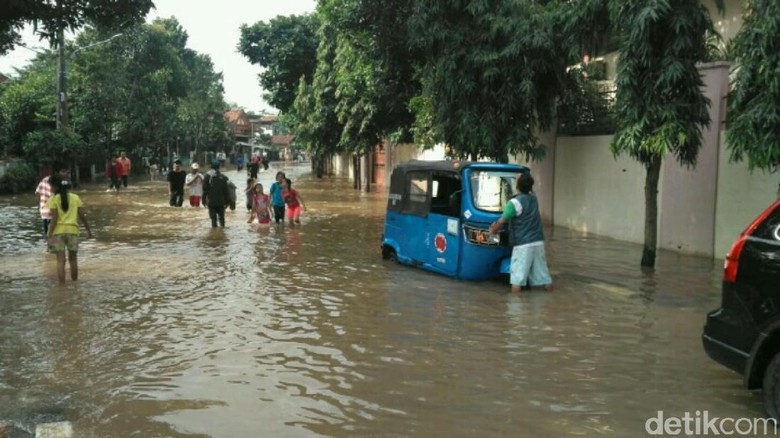
Banjir Jakarta di 5 Tahun Terakhir

Banjir Jakarta di 5 Tahun Terakhir

Jakarta – Sejak zaman kolonial, Jakarta (dahulu Batavia) selalu menjadi ‘langganan’ banjir. Hingga kini banjir masih melanda wilayah Jakarta, salah satunya banjir besar yang terjadi kemarin.

Banjir terjadi akibat wilayah Jakarta dan sekitarnya diguyur hujan sejak Selasa (21/2/2017) dini hari hingga siang. Sejauh ini tercatat sudah ada 2 korban jiwa dan 1.613 pengungsi.

Berdasarkan catatan detikcom dari berbagai sumber, rata-rata banjir di Jakarta terjadi pada awal tahun. Namun, pada 2013, banjir terjadi pada akhir tahun akibat tanggul Latuharhary yang jebol.

Sementara itu, pada 2016, banjir rata-rata surut dalam 1-2 hari. Pada 2016, banjir yang tingginya lebih dari 1 meter terjadi beberapa kali dalam beberapa bulan.

Berikut ini data banjir di Jakarta sejak 2012:

Banjir 2012

Wilayah terdampak: 10 kecamatan
Waktu: 22 November 2012
Lama: 9 hari
Pengungsi: 820 orang
Korban jiwa: –
Kedalaman tertinggi: 2,5 meter
Kerugian: –

Banjir 2013

Wilayah terdampak: 35 kecamatan
Waktu: Januari 2013
Lama: 15 hari
Pengungsi: 83.930 orang
Korban jiwa: 19 orang
Kedalaman tertinggi: 4 meter
Kerugian: –

Banjir 2014

Wilayah terdampak: 37 kecamatan
Waktu: Januari-Februari 2014
Lama: 20 hari
Pengungsi: 62.819 orang
Korban jiwa: 23 orang
Kedalaman tertinggi: 4 meter
Kerugian: –

Banjir 2015

Wilayah terdampak: 38 kecamatan
Waktu: 8 Februari 2015
Lama: 7 hari
Pengungsi: 231.566 orang
Korban jiwa: 5 orang
Kedalaman tertinggi: 2 meter
Kerugian: –

Banjir 2016

Wilayah terdampak: 25 kecamatan
Waktu: Februari, Maret, April 2016
Lama: rata-rata 2 hari
Pengungsi: 70.218 orang
Korban jiwa: –
Kedalaman tertinggi: 2-3,6 meter
Kerugian: –

Banjir 2017 (sampai 22 Februari)

Wilayah terdampak: 15 kecamatan
Sejak tanggal: 21 Februari 2017
Lama: –
Pengungsi: 1.613 orang
Korban jiwa: 2 orang
Kedalaman tertinggi: 1,5 meter
Kerugian: –

Study reveals thousands of buildings in Victoria at risk of earthquake destruction

A new study shows nearly 4,000 buildings in Victoria are at risk of complete damage from a major earthquake.

It’s only the second such analysis — after one by the District of North Vancouver in 2015 — conducted recently by communities in southwestern B.C. which are beginning to grapple with increasing scientific knowledge that a major earthquake will be devastating.

While Victoria has responded to the study by expanding a program to seismically upgrade heritage buildings, it will only add 60 buildings to an eligible pool now totalling 222, and which accounts for only five per cent of the buildings identified at significant risk in the study.

Following the release of the study, Victoria city councillor Geoff Young noted it was going to be a long and sometimes painful process readying the city, the province’s capital, for a big earthquake.

Relokasi Korban Bencana Ditarget Tuntas Empat Bulan

BANGLI,  – Pemerintah Kabupaten Bangli kini tengah berupaya menyiapkan lahan yang aman untuk merelokasi warga korban bencana alam yang selama ini tinggal di kawasan zona merah bencana. Rencananya para warga korban bencana tersebut akan direlokasi ke lahan hutan milik pemerintah yang ditukar guling dengan lahan milik warga yang terkena bencana.

Selain menyiapkan lahan, Pemkab Bangli rencananya juga bakal membantu pembangunan rumah untuk korban bencana alam yang sebagian biayanya diambil dari sumbangan para donatur.

“Kalau pindah ke daerah hutan hukumnya harus ada pengganti satu kali tiga. Satu are tanah hutan nanti ditukar dengan 3 are tanah milik warga. Tanah yang akan dibanguni rumah di tempat yang rawan diserahkan ke pemerintah, nanti pemerintah akan membebaskan hutannya,” jelasnya.

Meski sudah mendapat izin untuk memanfaatkan lahan hutan sebagai tempat merelokasi warganya, namun rencananya Bupati Made Gianyar akan menawarnya kembali. “Kita akan tawar. Karena ini bencana bukan untuk kepentingan bisnis, kita akan tawar 1-1 (satu are tanah hutan ditukar dengan satu are tanah milik warga yang terkena bencana),” ujarnya.

Kalau nantinya tidak disetujui menukar 1-1 dan hanya disetujui 1-2, maka pihak Pemkab nantinya akan berupaya mencarikan satu are lagi untuk pengganti lahan hutan milik Pemerintah.

“Mengenai lokasi lahan hutannya sejauh ini belum ada kepastian. Tim masih turun. Yang jelas lahan hutan yang akan kita mohonkan adalah lahan hutan yang tidak masuk zona merah. Kita targetkan penyiapan lahan termasuk pembangunan rumah untuk korban bencana selesai dalam waktu empat bulan,” tegasnya. (dayu rina/balipost)

Bupati Bangli I Made Gianyar saat ditemui di Posko Utama Tanggap Darurat di Kantor Camat Kintamani, menjelaskan, pasca status tanggap darurat dicabut, pihaknya sempat melakukan pertemuan dengan Gubernur Bali Made Mangku Pastika Sabtu lalu.

Pemprov Bali sangat memberikan perhatian besar terhadap bencana alam di Bangli dengan membantu memfasilitasi pemulihan kondisi korban, infrastruktur jalan, serta jembatan yang rusak akibat bencana alam. Hal itu dilakukan agar perekonomian masyarakat yang beberapa lebih dari sepekan terakhir tersendat akibat bencana bisa segera pulih, katanya, Minggu (19/2).

Gianyar mengatakan, dalam pertemuan itu dibahas juga soal rencana perelokasian warga korban bencana yang selama ini tinggal di kawasan zona merah bencana ke tempat yang lebih aman.

sumber: BALIPOST.com

10 Geolog Asal Jepang Tertarik dengan Gempa Bumi yang Melanda Kota Medan

MEDAN – Kabar gempa yang simultan terjadi di Sumatera ternyata sampai ke mancanegara. Bahkan, sejumlah geolog asal Jepang tertarik ingin melakukan penelitian di Sumatera Utara.

“Ada 10 ahli geologi asal Jepang yang sudah turun ke lokasi gempa. Mereka tertarik dan ingin mempelajari lebih lanjut kenapa belakangan ini gempa sering terjadi di Sumatera Utara,” kata Kepala Badan Penanggulangan Bencana Daerah (BPBD) Sumut, Riadil Akhir Lubis, Rabu (15/2/2017).

Menurut Riadil, kedatangan ahli geologi asal Jepang ini cukup membantu tim pemantau gempa bumi di Sumatera Utara.

Para peniliti dari Sumatera Utara bisa berbagi ilmu dan informasi menyangkut antisipasi bencana gempa.

“Tentu kedatangan para geolog ini bisa memperkaya informasi menyangkut ilmu lempeng bumi bagi geolog di Sumatera. Kita juga dapat belajar, bagaimana menghadapi gempa bumi jika getarannya berkekuatan cukup besar,” ungkap Riadil.

Sementara itu, tim Badan Meteorologi Klimatologi dan Geofisika (BMKG) Wilayah I Medan turut mengirimkan tim analisisnya ke kawasan Tanah Karo, tepat di titik gempa. Mereka juga membawa suatu alat untuk mengukur aktivitas seismik di lokasi pusat gempa.

sumber: TRIBUN-MEDAN.com

Drones could save your life in a natural disaster

With Japan’s track record of natural disasters, the country is understandably always on the lookout for ways to better prepare itself.

Japan is now looking to the skies, working to develop drones to help out in the case of an earthquake or other trouble.

The country last week trialled special drones mounted with speaker systems that can direct citizens to nearby evacuation areas, reports Jiji Press. These busy bees also monitor wind speeds around skyscrapers, taking images of the streets below.

With GPS built into the devices, self-flying was also tested, with the drones moving along set flight paths through the high-rise area.

The trials took place in Shinjuku, a highly populated area in Tokyo, with radio channels built specially for the test.

It’s not the first attempt by Japan to use new tech for disaster prevention — a university in the country last year looked to Oculus Rift to train citizens on how to act in the case of a tsunami, for instance. Meanwhile, drones last were in the spotlight at the Super Bowl, when Intel-powered drones lit the sky up.

Mensos Kofifah Tinjau Lokasi Bencana di Desa Songan

BANGLI, BALIPOST.com- Menteri Sosial Khofifah Indar Parawansa, mengunjungi korban bencana alam tanah longsor di Desa Songan Kintamani, Bangli, Senin (13/2). Selain meninjau langsung lokasi longsor di Banjar Bantas, Mensos dalam kesempatan tersebut juga memberikan sejumlah bantuan kepada korban luka dan ahli waris korban meninggal.

Kedatangan Mensos Khofifah Indar Parawansa bersama sejumlah pejabat di Kementerian Sosial disambut Wabup Bangli Sang Nyoman Sedana Arta, Dandrem Kolonel Inf. Nyoman Cantiasa, Dandim Bangli Letkol Inf. Susanto Lastua Manurung, Kapolres dan sejumlah pejabat Pemkab Bangli dan masyarakat setempat.

Sebelum meninjau lokasi longsor di Banjar Bantas, Mensos menyempatkan diri mengecek logsitik dan meninjau langsung kondisi dapur umum serta tenda pengungsian yang lokasinya tak jauh dari setra adat setempat.

Kedatangan Mensos Kofifah menyampaikan duka cita sedalam-dalamnya terhadap masyarakat yang menjadi korban bencana alam di Kintamani. Dalam kesempatan tersebut Mensos meminta masyarakat untuk sabar dan tabah atas musibah yang terjadi.

Mensos menyatakan bahwa belakangan ini Indonesia mendapat banyak ujian bencana alam seperti banjir dan longsor. Atas kondisi itu pihaknya meminnta langkah antisipasi kini harus lebih ditingkatkan.

Program kampung siaga bencana yang di inisiasi Kementerian Sosial harus dibangun dan dikuatkan kembali supaya masyarakat yang ada di daerah-daerah rawan bencana bisa lebih waspada.

Mensos mengatakan, sebagaimana hasil kajian dari asesor bahwa wilayah di kaldera Kintamani yang sebagian besar berupa lereng, masuk dalam kategori zona merah. Sehingga dibutuhkan kehati-hatian dan kewaspadaan masyrakat untuk tetap menjadikan kawasan tersebut sebagai lahan berproduksi dan hunian.

“Ketika sudah kita lihat ada longsoran tanah yang akhirnya menimbulkan korban termasuk juga ada rumah yang tertimbun tentu akan dilakukan proses asesmen kembali, di titik mana yang masih bisa dilakukan untuk bercocok tanam dan hunian dan dititik mana yang memang sudah harus dibebaskan dari hunian,” jelasnya.

Sementara, kebutuhan logistik untuk korban bencana, Mensos mengatakan, dalam kondisi darurat seperti sekarang maka Bupati bisa mengeluarkan cadangan beras pemerintah (CBP) sampai 100 ton.

“Setiap kabupaten atau kota dimana ada bencana alam dan bencana sosial, dan sudah dikeluarkan SK darurat maka bupati/walikota bisa mengeluarkan CBP sampai 100 ton. Kalau yang 100 ton sudah terpakai maka bisa mengeluarkan SK dari gubernur bisa mengeluarkan cadangan beras 200 ton. Kalau yang 200 ton pun sudah habis baru mennggunakan SK menteri sosial. Pada dasarnya bahwa pada saat tanggap darurat tidak boleh ada masyarakat yang tidak tercukupi logistiknya,” tegasnya. (dayu rina/balipost)

Central Africa spurs disaster risk reduction

YAOUNDE, 13 February 2017 – Collective action by regional organisations is a key means to help countries reduce their risk of disasters, and the Economic Community of Central African States is stepping up its efforts to rein in the impact of hazards amid rising pressure from climate change.

The ECCAS secretariat, plus its 11 member states and partners have together set out a disaster risk management and climate change action plan to be implemented over the course of this year.

The ECCAS groups Angola, Burundi, Cameroon, Central African Republic, Chad, Congo, Democratic Republic of Congo, Equatorial Guinea, Gabon, Rwanda, and Sao Tome and Principe. Its member states include some of the least developed countries in the world.

Common disasters in their region number epidemics, droughts, floods, and storms.

Out of a total of 36 countries worldwide with ‘very high’ and ‘high’ risk profiles, half of them are African, according to the INFORM Index for Risk Management. Central African Republic, Chad, and Democratic Republic of Congo are in the top 10 ranking for the highest overall disaster risks.

Central African Republic and Chad are among the 10 countries globally facing the highest levels of risk in the Climate Change and Environmental Risk Atlas. Of the 32 countries identified globally as the most vulnerable in the atlas, Burundi, Central African Republic, Chad and Democratic Republic of Congo are also at ‘extreme risk’ in the Food Security Risk Index and exhibit high levels of poverty and/or conflict and displacement, all of which compound the potential impact of hazards.

Countries around the world raised the bar for disaster risk reduction and climate change action in 2015, when they adopted an interlocking set of agreements as part of the 2030 Agenda for Sustainable Development. The accords included the Sendai Framework for Disaster Risk Reduction, the Paris Agreement on climate change and the Sustainable Development Goals.

The Fifth Session of the Central Africa Platform on Disaster Risk Reduction, in December in Cameroon’s capital Yaoundé, convened to focus on the need to synergise the Sendai Framework and the Paris Agreement in order to implement the Central Africa Strategy on Risk Prevention and Disaster Management.

“The regional platform placed under the aegis of ECCAS is a crucial body that allows stakeholders to share their achievements and constraints and to jointly face the challenges posed by disasters in a coordinated and harmonised way,” said Ms. Elisabeth Huybens, Director of the World Bank Office in Cameroon.

A total of 75 representatives drawn from ECCAS states, national focal points in disaster risk reduction, climate, water and meteorology, UNISDR, the World Bank Group’s Global Facility for Disaster Reduction and Recovery (GFDRR), civil society and the Parliamentarians Network for Resilience to Disasters in Central Africa (REPARC) attended the meeting.

The session came just weeks after the adoption of the ‘Programme of Action for the Implementation of the Sendai Framework for Disaster Risk Reduction 2015-2030 in Africa’ at the Sixth Session of Africa Regional Platform and Fifth High Level Meeting on Disaster Risk Reduction, held in November in Mauritius.

One of the areas spotlighted in Yaoundé was the ECCAS disaster risk reduction data base, which will support the development of policies, strategies, institutions, early warning system and human resources was completed and validated.

Member States were also called upon to develop and strengthen disaster risk reduction frameworks and dialogue among all stakeholders, to ensure for better synergy in disaster resilience actions. They were also requested to ensure that their national strategies are developed and aligned with the Sendai Framework and other global agreements.

To ensure greater impact on policy decisions, the meeting also decided that REPARC – which was launched in 2015 with support from UNISDR and GFDRR – be involved in a multi-year programme entitled ‘Building Disaster Resilience to Natural Hazards in Sub-Saharan African Regions, Countries and Communities’, funded by the European Union in support of the African, Caribbean and Pacific Group of States.

The recommendations are to be implemented before the next ECCAS platform, planned this October.

Central Asia declaration reaffirms regional commitment to disaster law

Though rarely making headlines, disasters in Central Asia constitute one of the most significant threats to human security in the region. It is a vast area that is frequently affected by a range of natural hazards including earthquakes, floods, mudslides, landslides and avalanches. This, coupled with varying degrees of socio-economic development, highlights the need for Central Asian Republics to be well-prepared to mitigate, prepare for and respond to disasters.

States and National Red Crescent Societies in the region have been considering the issue of legal preparedness for disasters for a number of years now, and several consultations and initiatives have taken place. The need to have laws and policies in place to manage and respond to disasters was recognized with the adoption of a Model Act on International Disaster Assistance by the Inter-Parliamentary Assembly of Member Nations of the Commonwealth of Independent States (IPA CIS) in 2014.

The Republic of Kyrgyzstan is currently leading the way at the national level, with a new law on facilitating international disaster relief due for adoption this year. The draft law is based largely on the CIS Model Act on International Disaster Assistance, and the ‘Guidelines for the domestic facilitation and regulation of international disaster relief and initial recovery assistance’ (the ‘IDRL’ Guidelines).

Last month, the National Societies and Governments of four of the Central Asian states (Kazakhstan, Kyrgyzstan, Tajikistan and Uzbekistan) came together for a regional ‘consultative conference on legal aspects of disaster risk reduction’, held in Almaty, Kazakhstan on January 18. This event was hosted by the newly established Almaty Centre for Emergency Services and Disaster Risk Reduction (CESDRR) and was held within the framework of a project on ‘Consolidating and Strengthening DRR in Central Asia’, funded by the Department of the European Commission for Humanitarian Aid and Civil Protection (ECHO).

The parties to the conference in January adopted the ‘Almaty Declaration’, which outlines their commitment to strengthening disaster law. A Memorandum of Understanding on disaster preparedness and response was also signed by the Red Crescent Societies of Kazakhstan and Kyrgyzstan, the IFRC and the CESDRR, cementing their commitment to strengthen this area of work.

The workshop brought together representatives from National Red Crescent Societies, national authorities, UN agencies, and other key stakeholders in the region. It provided an opportunity to consolidate existing experience and developments, and identify a clear way forward for strengthening legal preparedness for disaster risk management, particularly at the national level.

Prior to the consultative workshop, the CESDRR hosted a ‘National Society Dialogue’ on disaster law, where the National Society representatives came together to discuss how to harness their unique auxiliary role and undertake effective legislative advocacy – the aim of which is to create tangible legal and policy change in the interests of the at-risk and disaster-affected communities which they serve.

It was clear from the discussions that law can play a fundamental role in establishing the necessary frameworks to facilitate many aspects of disaster risk management, especially when it comes to facilitating life-saving disaster relief in an emergency. As highlighted by the Director of the CESDRR, Mr. Valery Petrov, during his closing remarks, “at the end of the day it’s not just about moving goods across borders, it’s about saving people’s lives.”

Data Bencana di Jakarta pada Januari 2017

Jumlah Bencana DKI

Laporan Badan Penanggulangan Bencana Daerah (BPBD) DKI Jakarta menunjukkan kebakaran mendominasi kejadian bencana di DKI Jakarta pada bulan lalu, Januari 2017.
Sepanjang Januari, tercatat terdapat 66 kejadian kebakaran di ibu Kota dengan total kerugian mencapai Rp 21,6 miliar dan menyebabkan 350 kepala keluarga atau 1.324 jiwa kehilangan tempat tinggal.

Jakarta Januari 2017

Kebakaran di Jakarta sepanjang Januari 2017. (Foto: BPBD DKI Jakarta)

Hari ini (9/2), BPBD DKI Jakarta melalui akun Twitter-nya mengucapkan Selamat Hari Pers Nasional. Menyambut Hari Pers Nasional, BPBD DKI Jakarta merilis laporan kejadian bencana yang terjadi di DKI Jakarta sepanjang Januari 2017.
Kejadian bencana yang paling banyak terjadi setelah kebakaran adalah jalan tergenang akibat banjir. Ketinggian banjir tersebut menimbulkan genangan air setinggi 10-70 sentimeter yang berdampak di 4 Kecamatan, 5 Kelurahan, 7 Rukun Warga (RW), dan 7 Rukun Tetangga (RT).

Jakarta Januari 2017

Dampak banjir Jakarta sepanjang Januari 2017. (Foto: BPBD DKI Jakarta)

Selain bencana-bencana di atas, ada pula 2 Kejadian Luar Biasa (KLB) yang terjadi di DKI Jakarta sepanjang Januari 2017. Kedua kejadian itu adalah terbakarnya Kapal Zahro Express dan tenggelamnya perahu sampan pemancing di Pulau Tidung.

Jakarta Januari 2017

KLB di DKI Jakarta sepanjang Januari 2017. (Foto: BPBD DKI Jakarta)

Selain KLB, ada pula 4 konflik sosial yang terjadi di DKI Jakarta sepanjang Januari 2017. Kejadian tersebut menyebabkan 2 warung rusak.

Jakarta Januari 2017

Konflik sosial di Jakarta sepanjang Januari 2017. (Foto: BPBD DKI Jakarta)

Banyaknya kejadian bencana, kejadian luar biasa, dan konflik sosial yang terjadi di DKI Jakarta sepanjang bulan kemarin, semoga menjadi pelajaran bagi pemerintah dan masyarakat Jakarta agar kejadian-kejadian tersebut tidak terjadi lagi.