Ukraine in total natural disaster

Severe weather conditions left numerous cities without electricity, one person reported dead  Weather storm has covered nearly the whole territory of Ukraine.

Numerous regions report of accidents and power cuts caused by heavy rains and winds. Local residents also suffer from the consequences of natural disasters.

A 20-year-old man died in Kharkiv region amidst the field, his mother later found his body. In a while the medical expertise showed he had been struck by lightning and died because of electrical shock.

Ihor Lupandin, member of Ukraine’s State Emergency Service in Kharkiv Region: “The field is an open space, so it is no surprise the man was killed by lightning. The medics later confirmed he had been damaged by electricity. Except for the thunderstorm, there can be no other reasons.”

Torrential rains followed by thunderstorm struck several districts of the city of Kharkiv. The meteorologists say there have been a monthly rainfall level during one night. Four cars have been damaged so far, several multistoried buildings remain without roof, for it has been torn off by strong wind flow. The workers of communal service say they will need at least a couple of days to eliminate the results of the weather disaster.

15 villages in the whole region remain without electrical supply.

In the city of Dnipro the abnormal heat was replaced by heavy rains and thunderstorm. A great deal of rainfall has resulted in massive floods in the city centre, as well as the outskirts. In order to escape submerging deeply in water, numerous pedestrians had to climb up the benches. Those driving a car encountered additional problems, since the vehicles were not able to move through the entire water front. Some of the number plates were washed off, now the police seek for their owners. 

608xX

Photo courtesy – social media

One more accident caused by weather conditions happened in the city of Poltava, that is north-eastern Ukraine. A multistoried building caught fire after being hit by lightning. A portion of electricity struck the aerial on the roof, the next moment the flame encompassed the area of 500 square metres in total.

City administration sent the whole firemen staff to battle the fire. Despite big number of workers, they managed to extinguish the flame only three hours later. One of the flats on the 5th floor is totally burnt, 10 other apartments are flooded with water, the roof is also partially destroyed.

Ukrainian capital also suffered from bad weather. In the centre of Kyiv strong winds overthrew an old maple. No injuries reported, though the centennial tree damaged four cars, electrical cable, and protective net on one of the balconies. The vehicles belonged mainly to the workers of Ukraine’s Security Service that is situated close to the site. Now some of them are set to complain to the court.

Penanganan Bencana Purworejo Jadi Percontohan

Penangan Bencana di Purworejo

PURWOREJO – Penanganan bencana tanah longsor dan banjir di Kabupaten Purworejo akan menjadi percontohan di tingkat nasional. Badan Nasional Penanggulangan Bencana (BNPB) akan mendokumentasikan pola penanganan yang dilakukan semua unsur dalam menangani bencana yang menewaskan 46 jiwa itu.

Pihak BNPB menyebut, rencana itu didasarkan kondisi bencana di Kabupaten Purworejo yang terjadi di beberapa lokasi secara bersamaan dan masif. “Bencana banjir dan tanah longsor terjadi bersamaan, keduanya menyebabkan korban jiwa serta berdampak luas,” tutur Rahmawati Husein PhD, Dewan Penasehat BNPB, kepada KRjogja.com, Kamis (21/07/2016).

Menurutnya, kondisi tersebut memerlukan sebuah mekanisme koordinasi yang bagus. Penanganan bencana harus melibatkan seluruh unsur, baik masyarakat, pemerintah dan pihak swasta.

BNPB akan mendokumentasikan kegiatan respons dan pemulihan pascabencana Purworejo. “Ini menjadi pembelajaran yang baik. Apa yang terjadi di Purworejo bisa menjadi rekomendasi dalam pembuatan kebijakan tingkat lokal hingga nasional,” ungkapnya.

Rahmawati mengemukakan, respons Kabupaten Purworejo terhadap bencana telah terorganisasi dengan baik. Pemerintah melalui Badan Penanggulangan Bencana Daerah (BPBD) setempat mencoba berinovasi membuat jejaring sehingga penanganan bencana. “Tentu butuh kecepataan dan koordinasi, mungkin hal itu yang harus ditingkatkan. Instansi terkait juga harus secara otomatis menjalankan fungsinya dalam penanganan bencana, jadi tidak menunggu perintah atasan,” ujarnya.

Namun dalam penanganan, garis koordinasi tetap dipegang BPBD setempat sebagai lembaga yang ditunjuk undang-undang untuk menangani bencana. Fuadi Darwis menyatakan bahwa tidak semua daerah di Indonesia memiliki kapasitas yang sama bagusnya dengan Purworejo dalam menangani bencana. “Kapasitas itu yang harus sama-sama ditingkatkan,” ucapnya. (Jas)

sumber: (KRjogja.com)

Tanggap bencana, Pemkab siapkan dapur umum untuk korban banjir

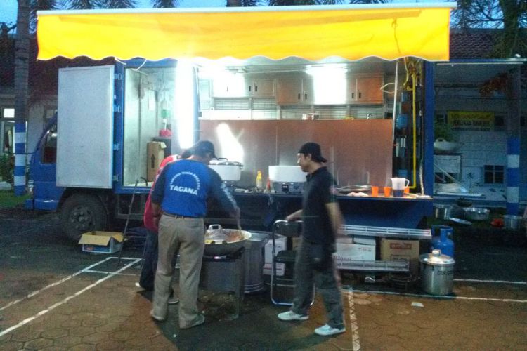
Banyuwangi.merdeka.com – Pemerintah Kabupaten Banyuwangi, menyiapkan dapur umum untuk korban banjir di Desa Wringin Putih, Kecamatan Muncar. Wakil Bupati setempat, Yusuf Widiatmoko, juga nampak memantau dapur umum tersebut sekaligus memberikan bantuan makanan cepat saji kepada para korban.

Meski banjir sudah surut sekitar pukul 11.00 WIB, hingga malam ini, tim Taruna Tanggap Bencana (Tagana) di bawah naungan Dinas Sosial (Dinsos) bersama BPBD akan terus standby sampai besok, Selasa (19/7).

Dapur umum didirikan sejak Senin sore, sekitar pukul 16.00 WIB oleh Tim Logistik Tagana untuk menyuplai kebutuhan makan korban banjir.

“Mulai berangkat dari markas kemudian masak sampai distribusi makanan maksimal 3 jam. Kami siapkan 800 bungkus makanan. Ini sementara ada telur, mi, ada sambal goreng jamur. Sarden untuk dimanfaatkan saat ini,” kata Koordinator Bidang Bencana Tagana, Karsono, kepada Merdeka Banyuwangi.

Karsono menambahkan, Taganan bersama BPBD akan terus standby sampai hari ini. Selain untuk mengantisipasi apabila ada banjir susulan. “Rencana cuma hari ini tapi kalau lihat kondisi masih hujan akan tetap standby terus,” ujarnya.

Sementara itu Nurhadi, Kepala Desa Wringinputih, mengatakan suplai logistik dapur umum memang untuk mencukupi kebutuhan makan warganya. Terutama yang tidak bisa memasak akibat perlengkapan dapur yang terendam.

Dia menambahkan, jumlah 800 bungkus makanan yang dibagikan merupakan hasil perkiraan jumlah 240 Kepala Keluarga (KK) dari 8 RT yang terkena dampak banjir. “240 dari perkiraan KK-nya. Total per KK kalau masing-masing KK dibuat 3 orang ya kurang lebih ada 800,” ujarnya.

Soal distribusi makanan, Nurhadi telah berkoordinasi dengan Kepala Dusun (Kasun), RW dan RT, yang terkena dampak banjir. “Ini masak selesai langsung dibagikan sekitar habis Magrib,” ujarnya.

Makanan tersebut didistribusikan lewat Kasun yang berkoordinasi dengan RT. Di Wringinputih sendiri ada tiga dusun; Krajan, Kabat, dan Tegalpare. Dari situ yang terkena dampak banjir Dusun Krajan, ada 2 RW dan 8 RT.

Minister’s earthquake prediction

What are they based on?

It is with bemusement that we note our Minister for Relief and Disaster Management giving such categorical assurance that Bangladesh will not experience a massive earthquake in the magnitude of 8 or 9 on the Richter scale. This he has said in the backdrop of a study by a geologist at Columbia University in New York City that has found that Dhaka sits on a dangerous fault which could trigger a massive earthquake affecting around 140 million people in the region that includes Bangladesh, India and Myanmar. 

While we are not suggesting for a moment that there will be a mega quake, we hesitate to rule out such a possibility altogether without scientific basis. Just because we have been lucky enough to be spared an earthquake of such magnitude for the last 200 years as the Minister has quoted, does not guarantee that it will not occur now or in the near future. While it is important for the minister to tell people not to panic, his dismissal of an earthquake of that scale occurring, we feel, is misplaced. Given that it is not possible to predict whether such an earthquake is imminent, or that it may occur after a few hundred years, the most prudent task for a country under risk would be to boost its preparedness for such a disaster.  

What the minister should be telling the public is how prepared the nation is or needs to be for such a disaster should it occur. This includes training rescue teams, mobilizing volunteers, educating the public on survival skills, keeping adequate hospital staff to attend to the injured, enough ambulances, firefighting facilities etc. Only such contingency plans can reassure the public.

62 people killed in natural disasters in U’khand this yr

DEHRADUN: The year 2016 is proving to be a terrible year for Uttarakhand in terms of human lives lost in natural disaster incidents. As per official figures, 62 people have been killed in natural disasters like flash floods, cloudbursts, landslides and forest fires as of Monday. Over 64 persons have been injured.

Even animals have had to bear the brunt of nature’s fury with around 887 animals including domestic cattle perishing in disasters since January this year. Besides loss of human lives, there has been considerable property loss as well with around 144 houses getting completely damaged and 133 sustaining severe damage in natural disaster incidents.

Elaborating on the reasons behind the high numbers, Santosh Badoni, deputy secretary, disaster management department, told TOI, “Uttarakhand is sensitive to natural calamities due to its terrain. Besides flash floods and landslides which take maximum lives in a year, the state is also one of the most seismic or earthquake-prone regions in the country with majority of its area lying in either the highly vulnerable Zone 5 or Zone 4.”

This year, Pithoragarh has been the worst affected disaster-hit district in the state with 17 causalities and eight people missing and feared dead in the series of cloudbursts which ocurred on July 1, triggering flash flood and landslides and wreaking havoc in the Bastadi, Naulanda, Charma and Pathorkot villages of the district.

Even Dehradun district reported 13 deaths due to natural disaster in the present year with as many as 10 workers being killed in a single incident when they were hit by a landslide in the Chakrata area in the month of May. Eight people lost their lives in Tehri district followed by Chamoli district where five persons have been killed this year.

Around 87 drinking water pipelines and 1184 electricity lines were also damaged during the natural disasters in Uttarakhand between January and July.

Data from the disaster management department shows that on an average 73 people have lost their lives every year in the state since 2001, mainly due to landslides and flash flood-related incidents. The average death count excludes fatalities during the 2013 catastrophe which alone killed over 4,000 people.

Overall, since its inception, the state has seen 1,016 people getting killed (excluding the 2013 disaster) in landslides and flash floods. In the last two years, landslides and flash floods have claimed 119 lives.

Ketua DPRD Bogor Minta Korban Bencana Pergeseran Tanah Direlokasi

Ketua DPRD Kabupaten Bogor Ade Ruhandi mengunjungi korban bencana pergeseran tanah di kampung Sikantor RT 01/05/, Desa Malasari, Kecamatan Nanggung, Kabupaten Bogor, Jawa Barat.

Bogor – Ketua DPRD Kabupaten Bogor Ade Ruhandi meminta warga korban bencana pergeseran tanah di kampung Sikantor RT 01/05/, Desa Malasari, Kecamatan Nanggung, Kabupaten Bogor, Jawa Barat, segera direlokasi ke tempat yang lebih aman. Korban bencana ini terdiri atas 58 keluarga.

Dia berjanji akan terus membantu relokasi warga kampung itu melalui rapat anggaran. Relokasi sangat mendesak dilakukan mengingat cuaca yang kurang mendukung. “Saya masih menunggu hasil kajian Kementerian ESDM terkait apakah tanah tersebut masih layak atau tidak untuk dihuni. Saya meminta kepada Pemerintah Kabupaten Bogor untuk merelokasi secepatnya warga Desa Malasari,” ungkap dia, Senin (18/7).

Dia berterima kasih kepada PT Aneka Tambang Tbk yang telah memberikan bantuan kepada warga yang terkena bencana. “Saya berharap mereka terus membantu warga dan warga lainnya yang ada di kecamatan Nanggung,” tambah dia.

Akhir pekan lalu, Ade bersama Adian Napitupulu, anggota DPR Komisi VII dapil Kabupaten Bogor, Dandim Kabupaten Bogor Letkol Czi Dwi Bima Nurahmat, dan Muspika Nanggung mendatangi langsung lokasi kejadian korban bencana pergeseran tanah. Warga berharap Ade bersedia membantu relokasi ke tempat aman.

“Kami takut kembali ke rumah apabila cuacanya hujan, karena khawatir longsor. Saat ini, tembok rumah kami sudah retak akibat tanah bergeser,” ujar Heni.

Adian Napitulu meminta Pemkab Bogor segera menyerahkan bantuan ke korban bencana. “Kalau pemerintah daerah kekurangan anggaran untuk membantu masyarakat, bisa mengajukan ke pemerintah pusat. Tapi, saya yakin Ketua Dewan dan Bupati Bogor bisa menanggulangi masalah ini melalui APBD Kabupaten Bogor,” kata dia.

Megathrust earthquake: Ticking time bomb threatening Bangladesh

A MASSIVE earthquake called an “active megathrust fault” is posing a genuine threat to southern Asia.

And if the modelling is correct, this earthquake could be at least as devastating as the 2011 quake which devastated Japan and took 16,000 lives.

The discovery of the hidden geographic fault lurking under southern Asia could unleash a magnitude 9.0 quake, placing up to 140 million people at risk in the most densely-populated place on earth, researchers fear.

The study of the area took more than a decade and detected the massive fault beneath Bangladesh, parts of India and Myanmar.

The research, the first to use GPS data collected from Bangladeshi tracking stations, suggests the northeastern corner of the Indian subcontinent is on a collision course with Asia.

The tectonic plates far beneath the earth’s surface are covered in layers of sediment more than 20m thick, and the study models suggest at the upper levels they are stuck in a pile-up, one thrusting under the other in a ‘megathrust’ which may have been under stress for more than 400 years.

Potential quake zone. Solid red line indicates an area of about 62,000 square kilometres that could move during a subduction-zone earthquake, affecting 140 million people or more. Image: Chris Small/Lamont-Doherty Earth Observatory

Potential quake zone. Solid red line indicates an area of about 62,000 square kilometres that could move during a subduction-zone earthquake, affecting 140 million people or more. Image: Chris Small/Lamont-Doherty Earth ObservatorySource:Supplied

Researchers believe the area is spring-loaded to buckle and rupture under the strain. But because their discovery is relatively recent, they have no idea when, or if, the fault will give way and trigger a 8.2 to 9.0 megaquake.

“We don’t know if it’s tomorrow or if it’s not going to be for another 500 years,” study co-author Michael Steckler, a geophysicist at the Lamont-Doherty Earth Observatory at Columbia University in New York City said in an article on the university website.

“We don’t know how long it will take to build up steam, because we don’t know how long it was since the last one. But we can definitely see it building.”

 
The research team estimates 140 million people live within 100km of the fault, including about 17 million in the area around low-lying Dhaka region of Bangladesh, which Steckler says already has problems with poor construction, making it hugely at risk of building collapse should a quake of large magnitude hit the region.

Overcrowding would make it difficult to rescue survivors in the event of an earthquake.

“Right now, the streets are clogged with traffic such that it’s impossible to drive around Dhaka on a normal day,” Steckler said. “If you fill the streets with debris, it’s really going to be impossible to get supplies and rescue equipment and things like that around,” Steckler told Live Science.

The research team is now building a more detailed map of the shape of the fault, as well as looking at historical tsunami data to understand how often megathrust earthquakes occur, Steckler said.

Japan tsunami hits Sendai

The March 11, 2011 Japan earthquake, with a magnitude of 9.0 struck off Japan’s northeastern shore and was the most powerful to ever hit the island country.

The quake triggered a devastating tsunami which struck the area with waves of up to 40m, tearing apart villages and towns, flattening homes and carrying ships inland, before sucking back to out to sea carrying debris, vehicles and bodies in its wake.

Damage to the Fukushima Daiichi Nuclear Power Plant completed a deadly treble of disaster, contaminating an area which continues to see more than 100,000 displaced locals living as evacuees.

Gempa Tiga Kali Goyang NTT

Ilustrasi (Okezone)

KUPANG – Provinsi Nusa Tenggara Timur tiga kali dilanda gempa dengan intensitas kecil dalam dua hari ini. Gempa terakhir terjadi, Kamis (14/7/2016) pukul 05.13 Wita dengan kekuatan 3,2 skala richter (SR).

Kepala Seksi Data dan Informasi Stasiun Kelas I BMKG Kupang, Sumawan mengatakan, gempa dengan kedalaman 58 kilometer itu berpusat di 26 kiometer barat laut Kabupaten Manggarai Barat, NTT.

Sementara pada Rabu 13 Juli 2016, NTT dua kali digoyang masing-masing berkekuatan 3,6 SR yang terjadi pukul 14.53 Wita dan berpusat di Sumba Barat Daya. Kemudian gempa 4,7 SR pukul 21.13 Wita di Kabupaten Alor.

Legarda: Disaster preparedness must be a way of life

MABALACAT CITY — In observance of the National Disaster Consciousness Month, Senator Loren Legarda has renewed her call to make disaster prevention and preparedness a way of life.

“When we reduce disaster risks and we are all prepared, informed and equipped, natural hazards like typhoons, earthquakes, tsunamis, storm surges, will not turn into disasters,” said Legarda, UNISDR Champion for Global Resilience.

“For instance, a magnitude 7.2 earthquake will not cause deaths or damage if there are no buildings on the fault line or if buildings and structures are built to withstand such a strong earthquake. A storm surge will not turn into a disaster if there are no settlements near the coastlines, or if there are enough mangroves to serve as buffer, or if residents are evacuated ahead of time, disaster management agencies give timely advisories and people follow the warnings,” she said.

Legarda stressed that there are many ways to prevent disasters. “We may be vulnerable to natural hazards and the effects of climate change, but we do not have to be helpless. We must be in control, we must be proactive, we must take urgent action.”

The Senator reiterated key lessons from previous disasters, which should guide the country toward strengthening disaster risk reduction and management.

First, we must focus on managing the risks rather than managing disasters. Disaster risk management should not be carried out only right before calamities happen. Local government units (LGUs) should be at the forefront of the planning, preparation and execution of the plans to provide an effective “first line of defense” against disaster risks. Funds should be sufficiently allocated. Cooperation among local and national governments, businesses, and the communities is imperative.

Second, we must let science work for our communities. The best solutions are possible only with the guidance of science, which is essential to develop land use plans that are risk sensitive. Accurate scientific data is needed to design practical solutions and communicate the risks to the people because knowing when, where and in what magnitude a typhoon will strike is fundamental to keeping our people prepared.

Third, everyone should be disaster-literate. We need to know and understand the risks. Everybody should be part of the solution and action needs to come from the communities themselves. Early and mandatory evacuation would be useless if the people do not understand the need for such efforts. Raising public awareness should be made to resonate loudly and as far deep into the communities as possible.

Fourth, we must protect our environment and pursue green urban development. We need to go back to the basics: protect our ecosystems and natural buffers such as mangrove forests to mitigate floods, storm surges and other hazards. Design and enforce building standards to address future hazards, not past ones.

Fifth, prepare adequately and engage. While disaster prevention should be the greater focus of our efforts, response preparedness is likewise important to prevent further casualties and reduce losses. Contingency plans are crucial in times of disasters. LGUs must have the political will to implement forced evacuation when called for.

Legarda has been engaged in efforts to raise awareness and educate government agencies, private sector, and citizens on disaster prevention and preparedness.

In 2011, the Senator collaborated with various government agencies to produce the Disaster Preparedness and First Aid Handbook, a practical manual that educates citizens on how to prepare for and respond to both natural and human-induced hazards.

An audio-visual version of the book was launched in 2013.

“Ligtas”, an instructional video on disaster preparedness, was produced by Legarda and directed by multi-awarded Kapampangan Indie film director Brillante Mendoza.

source: sunstar.com

Potensi Bencana Meningkat, BPBD Malang Siapkan Posko

Ilustrasi (Okezone)

MALANG – Badan Penanggulangan Bencana Daerah (BPBD) Kabupaten Malang, Jawa Timur, menyiapkan posko darurat bencana sejak menjelang Lebaran hingga September. Posko tersebut disediakan karena wilayah itu diprediksi sudah memasuki fase rawan bencana alam.

Kepala BPBD Kabupaten Malang, Hafie Lutfi, mengatakan Kabupaten Malang memasuki fase rawan bencana akibat gelombang La Nina yang dimulai Juni lalu dan diperkirakan hingga September mendatang.

“Berdasarkan pantauan kami, ada potensi peningkatan bencana sehingga memberlakukan kebijakan darurat bencana banjir, longsor, dan pohon tumbang,” ucapnya, Kamis (7/7/2016).

Hafie mengungkapkan, keberadaan posko bencana tersebut sangat penting. Bahkan, posko tersebut sudah beroperasi sejak Juni dan kemungkinan hingga September.

Posko bencana juga dilengkapi berbagai kebutuhan mendasar ketika terjadi bencana, termasuk mobil tangki air bersih yang bisa didistribusikan kepada masyarakat.

Selain petugas dari BPBD Kabupaten Malang, Hafie menjelaskan, pihaknya juga melibatkan personel dari Wahana Lingkungan Hidup (Walhi) dan PMI. “Koordinasi dengan berbagai pihak terkait juga terus kami instensifkan agar jangan sampai putus komunikasi,” ujarnya.

Sementara itu, Koordinator Posko Bencana, Dixie mengatakan setiap hari hingga September mendatang ada lima hingga 10 orang yang berjaga di posko. “Tim posko juga dibekali berbagai peralatan untuk penanggulangan pertama jika terjadi bencana, seperti perahu karet dan ekskavator,” katanya.

Sementara itu, BMKG mengimbau warga yang ingin memanfaatkan libur Lebaran dengan rekreasi ke pantai selatan sebaiknya lebih waspada dan berhati-hati. Itu karena secara umum gelombang laut mencapai 1,2 hingga 2,5 meter. Bahkan, ada potensi gelombang tinggi hingga mencapai 3,5 meter sampai empat meter.

Gelombang tinggi tersebut diperkirakan baru berangsur-angsur turun pada Jumat 8 Juli 2016. Sementara kecepatan angin antara 30 hingga 50 kilometer per jam.

Potensi bencana alam, baik banjir, tanah longsor dan puting beliung terjadi di sejumlah kecamatan, seperti Kecamatan Pujon, Ngantang dan Kasembon (Malang barat), Kecamatan Tumpang, Poncokusumo, Pakis (Malang timur), serta Kecamatan Tirtoyudo, Donomulyo, Ampelgading, Sumbermanjing Wetan di wilayah Malang selatan.

Sejumlah pantai yang berpotensi gelombang tinggi di kawasan Pantai Selatan, di antaranya Pantai Bajulmati, Goa China, Balekambang, Sendangbiru, Tamban, Lenggoksono, Ngliyep, dan Pantai Bengkung.

(erh)