New Zealanders better prepared for disasters: survey

WELLINGTON, Aug. 8 (Xinhua) — New Zealanders have never been better prepared for disasters, according to an annual disaster preparedness survey released on Tuesday.

Levels of household preparedness for disasters have risen sharply since the Kaikoura earthquake last November, followed by a string of other emergencies such as the Port Hills fires in Christchurch and the Edgecumbe flooding in the Bay of Plenty, Minister of Civil Defence Nathan Guy said in a release.

Current levels of preparedness are on par with the previous highest on record, which was following the Canterbury earthquakes in 2010 and 2011, Guy said.

The results are the findings of the disaster preparedness survey for 2017, conducted by Colmar Brunton, a social research company, which has been released by the Ministry of Civil Defence & Emergency Management.

The survey shows that 83 percent of respondents know that they needed to evacuate when a long or strong earthquake happens near the coast.


Sebagian Besar Wilayah NTB Tergolong Rentan Bencana

Ilustrasi.

REPUBLIKA.CO.ID, MATARAM — Wakil Gubernur Nusa Tenggara Barat (NTB) Muhammad Amin mengatakan sebagian besar wilayah NTB tergolong rentan bencana.

“Dari 14 jenis potensi bencana di Indonesia, 11 di antaranya terdapat di wilayah NTB. Penyebabnya kondisi geologis NTB terutama di wilayah pegunungan dan pesisir pantai, mulai dari barat sampai timur rawan bencana,” ujar Amin saat membuka rapat koordinasi peningkatan kapasitas pemerintah dan masyarakat dalam penanganan bencana di Hotel Lombok Raya, Mataram, NTB, Selasa (8/8).

Amin menyampaikan mengantipasi kerentanan bencana tersebut, tidak hanya membutuhkan program penanganan secara komprehensif dan terintegrasi, tetapi juga menyiapkan masyarakat agar tangguh bencana.

Menurut Amin, kejadian bencana sudah pasti akan menurunkan bahkan melumpuhkan tingkat produktivitas masyarakat. “Misalnya, tidak sedikit lahan yang tadinya bisa ditanami ketika datang bencana banjir akan rusak, dan juga infrastrukturnya rusak,” ucap Amin.

Merujuk pada Undang-Undang Nomor 24 Tahun 2007 tentang penanggulangan bencana, Amin mengingatkan, penyelenggaraan penanggulangan bencana merupakan tanggung jawab pemerintah pusat dan pemerintah Daerah.

Pria kelahiran Sumbawa, NTB, berharap dalam menjalankan amanah konstitusi tersebut, perlu disusun suatu konsep penangulangan bencana yang terencana, terkoordinasi dan menyeluruh, mulai dari tahap pra-bencana, saat tanggap darurat, dan pasca bencana.

Amin meminta pemerintah daerah dan semua pihak terkait untuk menyatukan langkah-langkah taktis yang cepat dan tepat untuk meminimalisir dampak bencana sekaligus mempersiapkan diri untuk menghadapi resiko bencana di masa depan.

“Sebagai langkah preventif, saya meminta BPBD NTB selaku leading sector penanggulangan bencana lebih mengintensifkan sosialisasi kepada masyarakat agar menjadi masyarakat tangguh bencana,” kata Amin.

Asisten Seputi Tanggap Cepat Bencana Kementerian Koordinator Pemberdayaan Manusia dan Kebudayaan (Kemenko PMK) Joko Yuwono berharap hasil rakor ini memperoleh masukan-masukan dan pemikiran serta komitmen lebih jauh lagi agar dapat mengantisipasi berbagai permasalahan kebencanaan.

“Untuk selanjutnya dapat dirumuskan berbagai langkah upaya penanggulangan melalui keterpaduan kebijakan dan perencanaan khususnya dalam pengurangan resiko bencana,” ucap Joko.

Asisten Deputi Pengurangan Resiko Bencana Kemenko PMK Herbin Manihuruk mengatakan berdasarkan hasil indeks resiko bencana 2014, dari 478 kabupaten/kota, 77 persen wilayah Indonesia merupakan risiko tinggi rawan bencana. Untuk NTB, lanjut Herbin, 88 persen wilayah di NTB menjadi lokasi prioritas.

Herbin melanjutkan, dalam mengantisipasi terjadinya bencana perlu ada sinkronisasi antara pemerintah pusat dan daerah. Herbin juga mengungkapkan gagasannya tentang upaya mewujudkan ketangguhan bencana di setiap desa. Artinya, ketika terjadi bencana, pihak pertama yang bisa menyelamatkan masyarakat, bukan BPBD atau Tim SAR tetapi masyarakat itu sendiri.

“25 persen bisa selamat karena diri sendiri, maka dari itu masyarakat harus kita internalisasikan bagaimana upaya-upaya penyelamatan diri. Jadi program pembentukan Desa Tangguh Bencana menjadi prioritas yang perlu kita sukseskan bersama,” ungkap Herbin.

Nepal Fatcsheet: Community-Based Disaster Risk Management (CBDRM)

This project aims to strengthen local capacity for emergency preparedness through a Community-Based Disaster Risk Management (CBDRM) approach and to increase the resilience of livelihoods through the prevention of landslide disasters and establishment of safer agricultural livelihood strategies. Prevention of landslide disasters in the targeted watershed areas reduces the loss of life and livelihoods related to such hazards.

The Gorkha Earthquake of April 25, 2015 in Nepal triggered thousands of landslides, affecting the lives and livelihoods of communities in rural areas where landslides are already frequent and serious hazards. The devastating earthquake not only impacted land productivity due to loss of mountain landmass and topsoil, but also affected settlements, resulting in loss of lives, properties and assets. Agriculture is the main source of food security, livelihood, and employment in the rural areas which are badly affected by natural calamities, such as earthquakes and landslides. As such, Nuwakot is one of six severely earthquake affected districts where risks due to landslides and erosion have increased and exacerbated the vulnerability of rural, agriculture-dependent farmers.

Consequently, the Department of Soil Conservation and Watershed Management (DSCWM) under the Government of Nepal (GoN) Ministry of Forests and Soil Conservation (MoFSC) has initiated an effort to harmonize landslide inventory methods and standardize landslide hazard, vulnerability, and risk-mapping methodologies. In response to these concerns, the UN Food and Agriculture Organization (FAO)—with support from USAID’s Office of U.S. Foreign Disaster Assistance (USAID/OFDA) is providing technical assistance to the DSCWM, supporting slope stabilization and landslide mitigation with proven technologies and experience. The project is a pilot initiative, demonstrating appropriate landslide treatment and mitigation techniques using the bi-engineering approach to reduce crisis in watershed areas.

PROJECT OVERVIEW

The MoFSC and the Ministry of Finance (MoF) have endorsed the project working modalities in December 2016. The DSCWM has formed a Project Steering Committee (PSC) with Focal Person for this program at the national level. The District Soil Conservation Office (DSCO) has nominated Focal Person as instructed by the DSCWM at local levels. The project team, along with Focal Persons, visited and finalized the priority sites for landslide treatment and mitigation together with livelihood support activities through Focused Group Discussion (FGD) among the direct beneficiaries.

PROJECT ACTIVITIES

  1. Received endorsement of the project from the MoF and MoFSC with the nomination of Focal Persons at national and district levels. The GoN focal persons, together with the FAO team, had a joint visit to the project sites and finalized a list of critical landslide areas for immediate treatment and mitigation, as well as several livelihood support activities.

  2. Selected a local NGO Service Provider based on a competitive basis in line with FAO Standard Procurement Guidelines.

  3. Provided training on nursery management and expects to produce 50,000 saplings of different species suitable for soil conservation and fodder trees.

  4. Developed user-friendly Agricultural Hazard and Vulnerability Mapping (AHVM) Tool Kit and short video as base line information.

  5. Mobilized the Community Forest User Groups (CFUG) in all three Village Development Committees (VDCs) and formed sub-groups within the CFUG for implementation of project activities.

  6. Completed the detailed survey, estimates, and designs in all three critical landslide areas for treatment and mitigation works.

7. Other regular ongoing activities include:

  • Support for landslide treatment and mitigation using suitable bio-engineering approach

  • Support local agriculture-based livelihood activities identified during the Focus Group Discussion

  • Regular nursery management and community plantation (CFUG)

  • Regular coordination among the government agencies, communities, and other relevant stakeholders working in landslide treatment and mitigation

  • Capacity building of beneficiaries and government officials on the bio-engineering approach in landslide treatment and mitigation and Early Warning System (training, exposure visits, and orientation etc.)

  • Develop community level “Watershed Management Plan” (Darkhukhola sub-watershed Level) Develop the Early Warning Systems at local level

  • Regular reporting and documentation of lessons learned and success stories

RESULTS ACHIEVED

The expected result of the project is to support earthquake-affected communities of 3 VDCs in Nuwakot’s Darkhukhola sub-watershed with appropriate technologies on landslide treatment and mitigation, and bolster safer livelihood activities to reduce loss of life and livelihoods due to landslide-related hazards.

Peduli Lingkungan Tekan Risiko Bencana

Gubernur Jawa Tengah Ganjar Pranowo. (JIBI/Solopos/Antara/Wisnu Adhi)

Solopos.com, SEMARANG — Gubernur Jawa Tengah Ganjar Pranowo meminta agar masyarakat Jateng mewujudnyatakan kepedulian terhadap lingkungan sekitar. Pelestarian lingkungan hidup diyakininya bisa mengurangi risiko bencana.

“Peduli terhadap sungai, gunung maupun laut jangan hanya digembar-gemborkan, tidak perlu dengan ide atau gagasan yang tinggi dan hebat, melainkan harus dipraktikkan dengan nyata meskipun aksinya kecil,” katanya di Semarang, Senin (7/8/2017).

Menurut Ganjar, kepedulian terhadap sungai, gunung, dan laut terkait erat dengan pengurangan risiko bencana, namun juga menyangkut keindahan, kesehatan, peningkatan kesejahteraan masyarakat, serta investasi intelektual. “Sebagai contoh, pengelolaan air di Umbul Ponggok, Kabupaten Klaten, yang mampu mengemas sumber air menjadi tempat wisata menarik dan menghasilkan pendapatan bagi desa setempat hingga mencapai lebih dari Rp10 miliar,” ujarnya.

Politikus PDI Perjuangan itu mengapresiasi masyarakat yang menggalakkan program tebar benih ikan ke sungai atau menanam pohon bagi orang yang menikah. Ganjar menyebutkan, Provinsi Jateng butuh kekuatan-kekuatan berbagai kelompok termasuk masyarakat, perguruan tinggi melalui riset-risetnya, serta pemerintah untuk memunculkan kepedulian semua pihak terhadap sungai, gunung, serta laut.

“Setidaknya keterlibatan komunitas-komunitas peduli alam dan lingkungan guna pengurangan risiko bencana,” katanya.

Berdasarkan data Badan Penanggulangan Bencana Daerah hingga awal Agustus 2017, kejadian bencana di Jateng 2016 naik dibanding 2015, yakni dari 1.573 kejadian menjadi 2.112 atau 34,2%. Kejadian bencana terbanyak adalah banjir 296 kali, tanah longsor 970 kali, kebakaran 468 kali, angin topan 418 kali dengan total kerugian diperkirakan mencapai Rp3,2 triliun.

Some Indonesian districts not on emergency alert for forest fires despite hotspots

http://www.channelnewsasia.com/image/9097746/16x9/670/377/212f9ac0aa608124c94aef73b822c517/KN/indo-hotspots-2.jpg

JAKARTA: Despite the detection of hotspots, some districts in Indonesia have yet to be on emergency alert for forest fires, said Indonesia’s National Disaster Mitigation Agency (BNPB) on Sunday (Aug 6).

In a statement, BNPB said the districts include those in Kapuas Hulu, Sanggau, Sintang and Landak – all in the West Kalimantan province.

West Kalimantan, however, declared an emergency alert status on a provincial level on Jul 26.

Satellite images from the National Institute of Aeronautics and Space (LAPAN) on Sunday showed there were a total of 282 hotspots across Indonesia, with 150 of them in West Kalimantan.

Hotspots were also detected in other provinces considered fire-prone areas – South Sumatra had 23, Riau 16 and Jambi with two. 

BNPB said forest fires started to appear in the Ogan Ilir regency of the South Sumatra province on Saturday. The agency deployed four helicopters to the region to conduct water bombing operations.

It added that districts that have many groups adopting the Fire Awareness Community and Village Disaster Mitigation programmes have managed to reduce hotspots this year.

“On the other hand, districts with few groups following the programmes have seen many hotspots appear in their area. This shows areas with low monitoring capability are more prone to forest fires,” said BNPB spokesman Sutopo Purwo Nugroho.

The peak of the dry season is expected to last until September and the threat of forest fires may increase.

Source: CNA/aa

Mitigasi Bencana Tsunami dan Gempa Perlu Menyesuaikan Konteks Wilayah

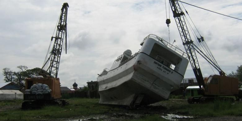
Sebuah kapal terdampar di lapangan yang jauh dari laut setelah tersapu tsunami Aceh, 26 Desember 2004 silam. Foto diambil setahun setelah kejadian.

JAKARTA, KOMPAS.com – Peneliti Universitas Brigham Young University (BYU), Ronald Albert Harris berpendapat, ada beberapa kelompok masyarakat tidak mengetahui sejarah tsunami di wilayahnya.

Misalnya, masyarakat di Waingapu, Sumba Timur. Selain itu masyatakat di Bali juga tidak mengetahui bahwa mereka hidup di bekas endapan tsunami purba.

Padahal, menurut penelitian Ron, mengetahui sejarah bencana di lokasi tempat tinggal merupakan hal penting bagi keberlangsungan masyarakat setempat. Selain itu, sebagai upaya penyusunan gagasan mitigasi bencana yang efektif dan efisien.

Hal ini dikatakan Ron dalam diskusi terkait mitigasi bencana gempa bumi dan tsunami di Badan Meteorologi, Klimatologi dan Geofisika (BMKG) pada Jumat (4/8/2017), sebagaimana disampaikan oleh Kepala Pusat Data, Informasi dan Humas BNPB Sutopo Purwo Nugroho melalui keterangan tertulisnya, Minggu (6/8/2017).

Berdasarkan penelitian yang dilakukan Ron, beberapa gagasan mitigasi bencana gempa bumi dan tsunami dapat menjadi acuan dalam penanggulangan bencana di Indonesia. Untuk beberapa wilayah di Jawa dan pulau-pulau Sunda kecil, misalnya.

Berdasarkan penelitian, Ron Harris menggagas jargon 20–20–20.

“Angka itu bukan sekedar angka yang kemudian muncul begitu saja. Namun, angka ini berdasarkan kalkulasi saintifik yang memperhitungkan durasi gempa yang terjadi, kecepatan tsunami dan wilayah evakuasi aman,” kata Sutopo, melansir ucapan Ron.

Adapun yang dimaksud dengan 20–20–20, yakni 20 detik gempa (5 km/det x 200 det = 100 km zona pecah), 20 menit evakuasi (tsunami velocity) dan 20 meter ketinggian (tsunami model menunjukkan 20 m gelombang run-up).

Meskipun demikian, menurut penelitian Ron, konsep mengenai mitigasi itu bisa berbeda-beda angkanya di setiap wilayah. Sebab, harus adaptasi dengan konteks wilayah.

“Mungkin saja di Ambon 20–10–20, atau di Bali 20–20–10,” ucap Sutopo, mengutip Ron.

Ron, menurut Sutopo, juga mengkritisi pemasangan rambu di beberapa daerah, salah satunya di Lombok, Nusa Tenggara Barat.

“Mencermati realitas dan hasil penelitian di lapangan maka untuk melihat kembali pemasangan rambu evakuasi seperti yang terpasang di Kuta Lombok. Rambu evakuasi tersebut menurutnya tidak mengarahkan pada tempat yang tinggi namun arah evakuasi masih menunjukkan wilayah yang terkena genangan tsunami,” kata Sutopo.

Sementara itu, upaya mitigasi di Pulau Dewata juga membutuhkan pendekatan di beberapa sektor seperti budaya, mengingat sesuai peraturan daerah yang mengizinkan bangunan dengan tinggi maksimal 15 meter.

Di sisi lain, berdasarkan pemodelan tsunami dari BYU bahwa dengan gempa bermagnitudo 9 di zona subduksi selatan Bali dapat memicu tsunami hingga lebih dari 20 meter.

Sementara terkait tanda peringatan, sebagian besar masyarakat memilih sirine. Data ini diambil dari warga di Pelabuhan Ratu, Pacitan, dan Pangandaran.

Namun, menurut Sutopo, Ron menegaskan bahwa terkait alat peringatan bencana itu perlu dipastikan selalu dalam kondisi baik atau tidak rusak.

“Sebagian besar masyarakat di Pelabuhan Ratu, Pacitan, dan Pangandaran memilih sirine. Namun yang terjadi, apakah semua sirine yang terpasang berfungsi secara baik?,” tutur Sutopo.
President Approves Disaster Declaration for Recent Flooding in Michigan

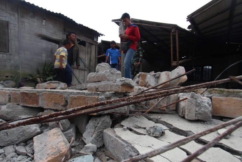
(TNS) – Today, President Donald Trump approved a major disaster declaration for Midland, Bay, Gladwin and Isabella counties along with the Saginaw Chippewa Tribe within Isabella County after the area experienced severe flood damage from storms on June 22-23.

“The losses sustained by these communities have been severe due to the magnitude of the flash flooding,” Gov. Rick Snyder said. “This presidential declaration is an important step in our continuing efforts to provide assistance and help Michigan families and businesses recover from the effects of this disaster.”

The decision releases federal funds for state and local governments to use in disaster recovery efforts and to help reduce the risk of such an event in the future. In addition, the disaster declaration makes individual assistance available to the families still recovering from recent flooding.

U.S. Rep. John Moolenaar welcomed the president’s decision.

“State and local governments in mid-Michigan have done an outstanding job in the aftermath of June’s flooding, but the cost of cleanup and recovery was more than they could bear alone,” Moolenaar said. “Today’s decision to grant federal assistance from FEMA will go a long way toward helping communities and families rebuild.”

Individuals seeking assistance in the formal disaster area can register with FEMA by visiting www.DisasterAssistance.gov or calling 1-800-621-3362. Those who have a speech disability or hearing loss and use TTY, should call 1-800-462-7585 directly; for those who use 711 or Video Relay Service, call 1-800-621-3362.

With this declaration, communities statewide are now eligible to participate in the hazard mitigation assistance program that can help reduce or eliminate long-term risk to people and property from natural hazards. Mitigation measures reduce personal loss, save lives and lessen the cost of responding to and recovering from future disasters.

“I strongly encourage communities to seize the opportunity for hazard mitigation assistance to enhance the safety of Michigan’s residents,” said Capt. Chris A. Kelenske, commander of the Michigan State Police, Emergency Management and Homeland Security Division. “With federal aid, our communities can initiate projects to save lives and protect public property and health.”

In addition to the presidential declaration for public assistance and hazard mitigation assistance, the U.S. Small Business Administration has made low-interest disaster loans available to residents and businesses in Bay, Gladwin, Isabella and Midland counties. Additional information about the SBA disaster assistance program is available at www.sba.gov.

The presidential declaration does not include assistance for costs incurred by state and local governments due to damage to public facilities and infrastructures because those costs did not meet the federal threshold for assistance. However, Snyder has opened the state’s Disaster and Emergency Contingency Fund, which allows eligible local governments affected by the flooding to apply for assistance grants for up to $100,000 or 10 percent of the previous year’s operating budget, whichever is less.

Sinabung Meletus Lagi, DPR Minta BNPB Turun Tangan

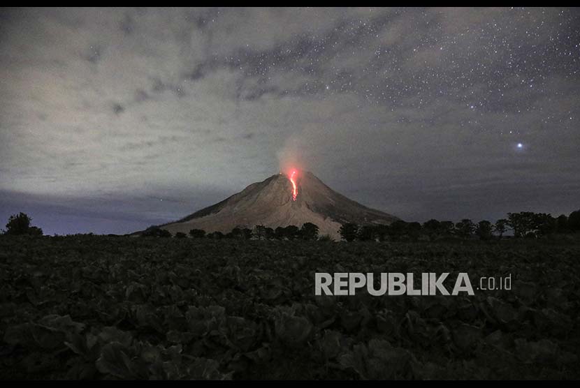
Foto dengan teknik long exposure menujukkan lava pijar Gunung Sinabung yang kembali meletus, Rabu (2/8)

REPUBLIKA.CO.ID, JAKARTA — Gunung Sinabung di Kabupaten Karo, Sumatra Utara, kembali meletus dengan melontarkan abu setinggi 4,2 kilometer. Letusan tersebut juga meluncurkan awan panas sejauh 4,5 kilometer ke arah tenggara dan timur pada Rabu (2/8) sekitar pukul 10.00 WIB.

Wakil Ketua Komisi VIII DPR RI, Iskan Qolba Lubis, meminta Badan Nasional Penanggulangan Bencana (BNPB) bergerak cepat menolong para penduduk terdampak.

“Sejauh ini berdasarkan laporan diketahui letusan itu membuat ribuan penduduk terdampak langsung dari hujan abu vulkanik,” kata dia dalam keterangan tertulis yang diterima Republika.co.id, Rabu (2/8).

Menurut Iskan, para penduduk terdampak itu sudah pasti membutuhkan suplai masker agar tidak tidak mengalami gangguan pernapasan. Dia menyebut, beberapa wilayah di sekitar kaki Gunung Sinabung bisa dikatakan mengalami dampak bencana yang parah. Hujan abu menyebar di beberapa tempat seperti di Desa Perbaji, Sukatendel, Temberun, Perteguhen, Kuta Rakyat, Simpang Empat, Tiga Pancur, Selandi, Payung, dan Kuta Gugung.

“Kondisi itu membuat warga membutuhkan masker dan air untuk membersihkan lingkungan. Apalagi berdasarkan laporan diketahui, di Desa Perbaji jarak pandang saat ini hanya tinggal 20 meter karena tertutup abu tebal,” ujar politikus dari Partai Keadilan Sejahtera (PKS).

Untuk itulah Iskan meminta BNPB dan BPBD segera melakukan kordinasi penanggulangan bencana meletusnya Gunung Sinabung. “Perlu dipikirkan langkah-langkah antisipatif, sehingga dapat meminimalisir terjadinya korban pascaterjadinya bencana,” kata dia.

Disaster preparedness now part of school curriculum

CEBU, Philippines – The disaster risk reduction and management (DRRM) has been institutionalized through its integration into the school curriculum.

We Are Sorry,
Video no longer available
Ecode: 9999

The Department of Education and the Commission on Higher Education in Central Visayas have incorporated disaster risk reduction and management in their curricula.

Section 14 of the Republic Act 10121 (or the Philippine Disaster Risk Reduction and Management Act of 2010) requires DepEd, CHED,  and Tesda to integrate disaster risk education in school curricula.

The law said DepEd and CHED have an important part to play in the country’s approach to DRRM.

DepEd and CHED officials agreed, saying students and teachers must be equipped with knowledge on mitigating and managing hazards and risks brought by natural disasters like earthquakes.

Victor Yntig, DepEd-7 Administrative Division chief, said the topics about disasters from basic information to disaster management have already been incorporated into the curricula of elementary and senior high school students.

Freeman ( Article MRec ), pagematch: 1, sectionmatch:

For elementary and junior high school, DRRM education is not a school subject itself but only a component of subjects like science and technology, and social science.

But DepEd made DRRM education as an independent subject for senior high school students.

Yntig said disaster preparedness and management education has been reinforced through programs and projects spearheaded by non-government agencies and the local government units.

He said experts from these agencies provide orientation and training on disaster mitigation and preparedness, as well as distribute DRRM manuals to students and school faculty members.

He said these initiatives started after the provinces of Bohol and Cebu were hit by the 7.2 magnitude earthquake and super typhoon Yolanda in 2013.

Aside from trainings and seminars, Yntig said, schools are directed to conduct hazard drills quarterly.

He said students should have knowledge on what to do during certain disasters like earthquakes.

On the other hand, college and university students are further capacitated through civic education and defense preparedness program.

Dr. Freddie Bernal, CHED-7 regional director, said disaster mitigation, preparedness and management is among the topics being taught to students through the National Service Training Program (NSTP).

He said all institutions are required to organize their respective disaster responders.

RA 10121 mandates local DRRM bodies to “encourage community, specifically the youth, participation in disaster risk reduction and management activities, such as organizing quick response groups, particularly in identified disaster-prone areas, as well as the inclusion of disaster risk reduction and management programs as part of youth programs and projects.”

Recently, CHED-7 partnered with the University of San Carlos in facilitating the training and workshop on the disaster response participated by NSTP directors and coordinators held in Barangay Talamban, Cebu City.

The Philippine Institute of Volcanology and Seismology (PHIVOLCS) earlier reported that Cebu would not be spared from experiencing strong earthquakes with the presence of “potentially active faults” in the province.

PHIVOLCS executive has asserted that every locality in the country will experience its own “big one,” referring to quakes with intensity eight, thus the need to intensify preparedness to mitigate risks. (FREEMAN)

Regional hospitals create network to prepare for disaster

Local hospitals have been preparing for the worst by creating a network of health care professionals coming together for one goal, to save lives.

“We have a number of emergency generators at Harborview. We also have fuel to last a really good reasonable length of time,” said Anne Newcombe, Harborview’s clinical director of emergency services.

Newcombe says power is key during an emergency. Keeping the lights on and machines running at Harborview Medical Center is the difference between life and death. The level one trauma center will be the hub of all medical aid in the event of a mass casualty. Despite the loss of internet during a catastrophic earthquake, Harborview says they have other mechanisms for finding out that information.

“We are prepared to look after patients for a number of days, weeks with also assistance from our local partners, other hospitals, public health, and Northwest Healthcare Response Network,” said Newcombe.

That network was put to the test during the crash on the Aurora Bridge. Careful planning sent patients to area trauma centers and hospitals to get the necessary level of care

That mass casualty event like any other disaster is coordinated in the radio room of Harborview. It’s a room used every day where emergency medicine physicians work with the Seattle Fire Department to provide medical guidance. It’s in partnership with the city and the fire department to provide care out in the field to patients. In addition they also provide guidance and care to airlift Northwest.

“In a major event whether it’s a large earthquake or a mass casualty this room becomes very active,” said Newcombe.

During an emergency, the radio room becomes the Disaster Medical Control Center (DMCC), where they will coordinate and work with medical professionals in the field, medics, and fire departments. Newcombe says typically paramedics will work with the physicians but during a major event they will take that burden off field personnel and coordinate patient distribution based upon level of injury.

But once those patients get to the hospital, the question is will there be enough medical personnel to treat them? Newcombe says in the event of a disaster the doctors, nurses, and support staff who are already at work are expected to stay as long as necessary.

“So one of the key pieces of this is really home preparedness,” explains Newcombe. “We expect our staff to stay to look after each other and look after patients and you can only do that if you know that your family, your dog at home are being well looked after. Otherwise she won’t be focused on caring and looking after patients here. So, home preparedness is essential…So, when you’re at work and an event occurs people will be staying so we provide and have planned for accommodation, so we have accommodation plans, we have plans for food, we have plans for charging their cell phones providing them with perhaps their communication lines. We do that so that our staff can actually stay here and care for the community, because that’s what we’re here for.”

However, she says the hospital staff will not have to face the surge of injuries alone. There are volunteer physicians and nurses prepared to jump into action in the event of a major incident to work in partnership with hospital staff who may be working for several days straight.

One of the most important elements in maintaining critical care is that none of the emergency rooms get overwhelmed. The goal is share the load.

The Northwest Health Care Response Network has redundant systems in place so that no one falls through the cracks. All hospital in the area will open their doors, including specialty care facilities like Seattle Children’s.

“Seattle Children’s becomes a hospital like any other hospital so we would be having people come to us by ambulance, which would most likely be children, but we would also have people just walking off the street or being delivered by their family members, and we would just take whoever came in the door,” said Margot Kravette, Manager of Emergency Preparedness at Seattle Children’s. “It’s our obligation to do that, and we provide excellent care to children and adults. We have to think about that though. We have to know that we have the right supplies to be able to take care of adults. And just as community hospitals don’t have pediatric, they have to be prepared to take children as well.”

While it’s reassuring to know that hospitals are prepared, the most important component to survival is being prepared at home. In the event of a major earthquake, emergency medical services will be slow, and it could be up to you to save a life.

“We want to make sure that the public are aware that having a really good robust first aid kit,” Newcombe said, “knowing how to put a tourniquet on for a bleeding limb. They know some of these principles so that they can also care for themselves or some of these other injuries that may occur.”